Maps of Bailly-en-Rivière
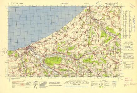
France 1:50,000 , Series GSGS 4250, Dieppe
France 1:50,000 , Series GSGS 4250. Great Britain. War Office. General Staff. Geographical Section. [London] : Ordnance Survey
Les Embouchures de la Somme et de Bresle Riv: où est S. Valeri, Eu et Dieppe
1 : 116600 Mollova mapová sbírka Fricx, Eugène Henry Harrewyn, Jacques Fricx, Eugené Henry
Les embouchures de la Somme et de Bresle riv. ou est St. Valeri, Eu et Dieppe
1 : 110000 Dieppe (Francie) Fricx, Eugene Henry Harrewyn, Jacques chez Eugene Henry Fricx
Les Embouchures de la Somme et de Bresle Riv. ou est St. Valeri, Eu et Dieppe
1 : 116600 Mollova mapová sbírka Fricx, Eugène Henry Covens, Johannes I
Les embouchures de la Somme et de Bresle Riv., où est St. Valeri, Eu et Dieppe
1 : 120000 J. Harrewyn f[ecit] Bruxelles : chez Eugene Henry Fricx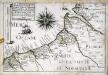
Les capitaineries garde-costes de St. Valery, Cayeu, Treport, Cryelle, Val de Conte, Dieppe, de la Chapelle S.te Marguerite, de la vallée de Senne, et celle du Crotoy
1 Karte : 22 x 33 cm de Fer
Carte particuliere du diocese de Rouen, 2
1 Blatt : Dezauche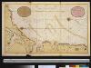
Een gedeelte van het Kanaal van Boulogne tot aen Sotteville int groodt
France Gerard van Keulen
Carte Particuliere des Environs de la Somme et de Bresle Riv. ou est St. Valeri, Eu et Dieppe
1 : 250000 Mollova mapová sbírka Seutter, Matthäus Lotter, Tobias Conrad Seutter, Matthäus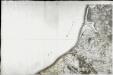
[Dieppe]
1 Blatt : 60 x 91 cm s.n.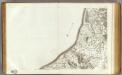
23 Dieppe.
1 : 86400 Cassini family; Cassini, Cesar-Francois, 1714-1784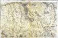
[Forges - Neufchâtel]
1 Blatt : 60 x 91 cm Brunet s.n.
Sheet 9. (Cary's England, Wales, and Scotland).
1 : 360000 Cary, John, ca. 1754-1835
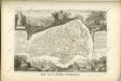
Département de la Seine inférieure
1 Karte : Kupferdruck ; 48 x 48 cm Houdan au bureau de l'atlas national de France rue Serpente n.o 15, et au cabient bibliographique rue de la Monnoye n.o 5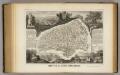
Dept. De La Siene Inferieure.
1 : 450000 Levasseur, Victor.
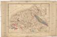
Carte géologique du département de la Seine-inférieure et des parties limitrophes des départements voisins
1 : 218500 Passy, M. A. Noel, M.
Le pais de Cavx
1 Karte : Kupferdruck ; 36 x 48 cm Mercator; Hondius; Tavernier imprimé chez Henrÿ Hondius, ches Melchior Tavernier aupres du Palais
LE PAYS | DE CAVX
[Amsterdam : Joan Blaeu]
Generalkarte von Zentraleuropa

Le Pais De Caux [Karte], in: Novus atlas absolutissimus, Bd. 4, S. 112.
1 Karte aus Atlas Janssonius Offizin
3) II.O. ''Boulogne'', uit: Carte géologique de France
1 : 500000 Annotatie: Voor aanwezige bladen zie bladoverzicht [S.l : s.n.]
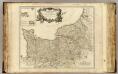
Carte de la province de Normandie, 2
1 Blatt : Esnauts et Rapilly
delineation of the strata of England and Wales, with part of Scotland
1 : 320000 Blatt 14 Smith, William Cary
Le gouvernement general de Normandie, 2
1 Blatt : chez l'auteur Jaillot
Picardiae, Belgicae regionis descriptio
1 : 66000

Gouvernement de L'Isle de France [Karte], in: Gerardi Mercatoris et I. Hondii Newer Atlas, oder, Grosses Weltbuch, Bd. 2, S. 56.
1 Karte aus Atlas Mercator, Gerhard und Hondius, Jodocus Jansson, Jan