Maps of Dikhil

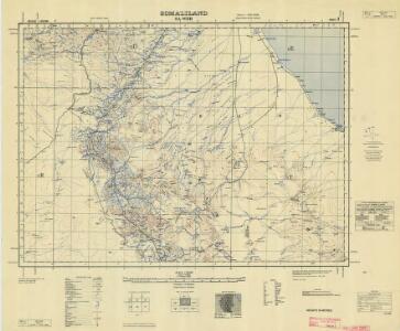
Somaliland 1:250 000, Sa-Wer
Somaliland 1:250 000 , Series GSGS 3927. Series in seventeen sheets covers former British Somaliland only. Sheetlines based on grid. Sheets numbered consecutively; 1 to 17. Great Britain. War Office. General Staff. Geographical Section. [S.l.] : War Office.
1 : 125,000 Somaliland Protectorate. Geological Survey. D.C.S. 1076, Abdal Qadr
1 : 125,000 Somaliland Protectorate. Geological Survey. D.C.S. 1076. [Surbiton] : Directorate of Colonial Surveys
1 : 125,000 Somaliland Protectorate. Geological Survey. D.C.S. 1076, Bawn
1 : 125,000 Somaliland Protectorate. Geological Survey. D.C.S. 1076. [Surbiton] : Directorate of Colonial Surveys
1 : 125,000 Somaliland Protectorate. Geological Survey. D.C.S. 1076, Qabri Bahar
1 : 125,000 Somaliland Protectorate. Geological Survey. D.C.S. 1076. [Surbiton] : Directorate of Colonial Surveys
1 : 125,000 Somaliland Protectorate. Geological Survey. D.C.S. 1076, Gocti
1 : 125,000 Somaliland Protectorate. Geological Survey. D.C.S. 1076. [Surbiton] : Directorate of Colonial Surveys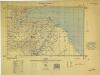
Somaliland 1:250 000, Zeila
Somaliland 1:250 000 , Series GSGS 3927. Series in seventeen sheets covers former British Somaliland only. Sheetlines based on grid. Sheets numbered consecutively; 1 to 17. Great Britain. War Office. General Staff. Geographical Section. [S.l.] : War Office.
Carta dimostrativa della Etiopia (Sheet 6)
Carta dimostrativa della Etiopia, in 6 fogli e 2 aggiunte, alla scala di 1 : 100,000. Compilata dal Capitano ... Ethiopia de Chaurand, etc. [Rome]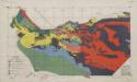
Soil map (Somalia)
[A collection of maps illustrating an economic survey and reconnaissance report on British Somaliland, G.P. numbers 2577 - 2593]. Great Britain. Army. East Africa Force. [S.l.] : 157 (E.A. & S.R.) Base Svy. Coy., E.A.E.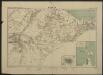
Carte de la côte française des Somalis et régions avoisinantes. Harrar
1 : 500000 Meunier, A., cartographe [Paris] : Service géographique des colonies
Carte de la côte française des Somalis et régions avoisinantes. Djibouti
1 : 500000 Meunier, A., cartographe [Paris] : Service géographique des colonies
Somaliland 1:250 000, Tug Wajale
Somaliland 1:250 000 , Series GSGS 3927. Series in seventeen sheets covers former British Somaliland only. Sheetlines based on grid. Sheets numbered consecutively; 1 to 17. Great Britain. War Office. General Staff. Geographical Section. [S.l.] : War Office.
Somaliland 1:250 000, Berbera
Somaliland 1:250 000 , Series GSGS 3927. Series in seventeen sheets covers former British Somaliland only. Sheetlines based on grid. Sheets numbered consecutively; 1 to 17. Great Britain. War Office. General Staff. Geographical Section. [S.l.] : War Office.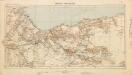
British Somaliland [showing routes] (1926)
British Somaliland [showing routes], GSGS 2991(b). Great Britain. General Staff. Geographical Section. [London] : [GSGS, War Office]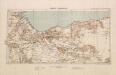
British Somaliland, GSGS 2991 (1922)
British Somaliland, GSGS 2991. Great Britain. General Staff. Geographical Section. [London] : [GSGS, War Office]
Adel. Afrique 33.
1 : 1641836 Vandermaelen, Philippe, 1795-1869
Carte d'Abyssinie et des contrées adjacentes dressée partie d'après des observations faites sur les lieux par l'auteur, partie d'après les informations prises dans le pays en 1809 et 1810
1 : 5000000 par Henry Salt [S.l.] : [s.n.]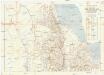
Seconda edizione della nuova carta dei domini e protettorati italiani nell' Eritrea e regioni limitrofe
1 : 1500000 Eritrea Ministero della guerra
British Somaliland and Sokotra
in British Somaliland and Sokotra. [With a map.] iv, 40 p. ; 8 -- . Great Britain. Foreign Office. Historical Section.
Carta della colonia Eritrea coll'Abissinia : e regioni limitrofe tra il Nilo, Suakin e il Golfo d'Aden
1 : 4000000 Cora, Guido, 1851-1917 Fratelli Bocca
Cestovatele Viléma Němce přehledná mapa Císařství habešského s poznámkami zoografickými a místopisnými
1 : 2070000 Etiopie Němec, Vilém Československá grafická unie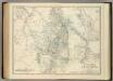
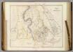
Upper Nubia and Abyssinia.
1 : 2854868 Johnston, Alexander Keith
Nubia, Abyssinia.
1 : 2854868 Johnston, Alexander Keith, 1804-1871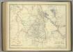
Upper Nubia and Abyssinia.
1 : 2854868 Johnston, Alexander Keith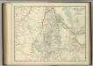
Upper Nubia and Abyssinia.
1 : 2854868 Johnston, W. & A.K.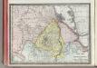
Upper Nubia and Habesh or Abyssina.
1 : 5000000 Rand McNally and Company
Countries In The Northern Tropical Regions of Africa.
Fullarton, A. & Co.
Abyssinia, surrounding countries.
1 : 6450000 Rand McNally and Company
Ethiopia. Pergamon World Atlas.
1 : 5000000 Polish Army Topography Service
AEthiopisches Hochland Alpenland Habesch und Vorstuffe von Darfur und Sennaar
Dárfúr (Súdán) Arrowsmith, John