Maps of Karpathos Regional Unit
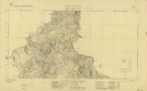
Isola di Scarpanto, Messocorio
Sheet 4 of the six-sheet series: Isola di Scarpanto. Istituto Geografico Militare. Rilievo del 1933. G.S.G.S. 4102. [London] : [War Office]
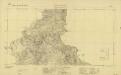
Scarpanto, Mediterranean Sea, Messocorio
Sheet F4 of the six-sheet series: Isola di Scarpanto. Istituto Geografico Militare. Rilievo del 1933. G.S.G.S. 4102. [London] : [War Office]
Archipelagi Insularum Aliquot Descrip., [Scarpanto] [Karte], in: Theatrum orbis terrarum, S. 341.
1 Karte aus Atlas Ortelius, Abraham Vrients, Jan Baptista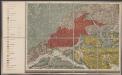
Candia cum Insulis aliquot circa Graeciam[:] [Scarpanto] [Karte], in: Gerardi Mercatoris Atlas, sive, Cosmographicae meditationes de fabrica mundi et fabricati figura, S. 493.
1 Karte aus Atlas Mercator, Gerhard Montanus, Petrus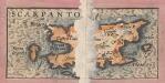
Archipelagi Insularum Aliquot Descrip., [Scarpanto] [Karte], in: Theatrum orbis terrarum, S. 246.
1 Karte aus Atlas Ortelius, Abraham
Candia cum Insulis aliquot circa Graeciam[:] [Scarpanto] [Karte], in: Gerardi Mercatoris et I. Hondii Newer Atlas, oder, Grosses Weltbuch, Bd. 2, S. 336.
1 Karte aus Atlas Mercator, Gerhard und Hondius, Jodocus Jansson, Jan
Rhodus Ins. [Karte], in: Gerardi Mercatoris Atlas, sive, Cosmographicae meditationes de fabrica mundi et fabricati figura, S. 523.
1 Karte aus Atlas Mercator, Gerhard Montanus, Petrus
Tabula Neoterica Crete Sive Candie Insule [Karte], in: Claudii Ptolemei viri Alexandrini mathematice discipline philosophi doctissimi geographie opus [...], S. 281.
1 Karte aus Atlas Waldseemüller, Martin [und Ptolemaeus, Claudius] Übelin, Georg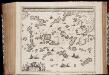
Archipelagi meridionalis, seu Cycladum insularum accurata delineatio / auctore I. Laurenbergio
1 : 650000 Annotatie: Kaart uitgegeven in de periode 1650-1662; Origineel is Blad 171 in atlas factice; Annotatie geografische gegevens: 4 schaalstokken: 8 Mill. Germ., en: 10 Mill. Gall., en: 30 Mill. Ital., en: 300 Stadia [S.l.] : [s.n.]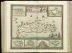
[83][83] Insula Candia ..., uit: Atlas sive Descriptio terrarum orbis
Annotatie: Gedigitaliseerde versie. Amsterdam. Heiloo : Picturae (vervaardiger), 2015. tiff-bestand. Gedigitaliseerd: 07-01-2015; Origineel: Universiteitsbibliotheek Vrije Universiteit (XL.05127.-) ; Netherlands; Titelpagina ontbreekt Wit, Frederik de Amsterdam : Frederick de Wit
CYCLADES | INSVLÆ | IN MARE ÆGÆO, | hodie | ARCHIPELAGO
Auctore | I. LAVRENBERGIO Amsterdami, J. Blaeu excudit
Archipelagi Meridionalis seu Cycladum Insularum accurata Delineatio. [Karte], in: Novus atlas absolutissimus, Bd. 10, S. 234.
1 Karte aus Atlas Janssonius Offizin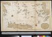
Het zuijderdeel van de Archipel Lagusche Eijlanden int groodt
Greece Gerard van Keulen
Europe 1:1.000.000
1 : 1000000 Kréta (Řecko) Geographical Section, General Staff
90. Anatolia occidentale, Isole Egee.
1 : 1500000 Touring club italiano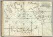
Carte De La Mer Mediterranee. XI.
Roux, Joseph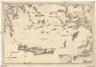
Mittelmeer
1 : 600000 Egejské moře Reichs-Marine-Amt
Iles de L'archipel; Dschezaïr
Nouvel atlas physique politique et historique de l'Empire ottoman et des états limitrophes en Europe, en Asie et en Afrique, en quarante feuilles Hellert, J.J. Bellizard, Dufour et Cie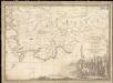
Parte dell'Asia Minore per servire di VI foglio della carta generale dell'Ungheria e della Turchia Europea
1 : 1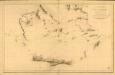
Carte réduite de la partie Méridionale de l’Archipel
Carte réduite de la partie Méridionale de l'Archipel, rédigée d'après les travaux exécutées dans les années 1818 & 1819 par M. Gauttier. [Paris] : Dépôt Général de la Marine
[Die Balkan-Halbinsel, Blatt 4]
Adolf Stieler's Handatlas über alle Theile der Erde und über das Weltgebäude Stieler, Adolf Justus Perthes
GRAECIAE ANTIQUAE DESIGNATIO NOVA
Řecko Lotter, Tobias Conrad impensis T. Conr. Lotteri
Graeciae antiquae designatio nova
Řecko Lotter, Tobias Conrad impensis T. Conr. Lotteri
L'Archipel.
1 : 1070000 Garnier, F. A., 1803-1863
Das Ägäische Meer mit Kreta
1 : 1750000 Egejské moře (oblast) Carl Flemming
Grecian archipelago
1 : 1840000 Egejské ostrovy (Řecko a Turecko) Smith, William Walker, C. Society for the diffusion of useful knowledge
Grecian Archipelago, ancient.
1 : 1860000 Society for the Diffusion of Useful Knowledge (Great Britain)
Feuille No. 1, uit: Carte de la Turquie d'Asie (moins l'Arabie) / dessiné et héliogravé au Service géographique de l'Armée
1 : 1000000 titelvariant: Turquie d'Asie; Annotatie: Titel boven de kaart: Turquie d'Asie; Bl. genummerd 1-4 en 7-10; Met lijst van de meest gebruikte woorden op de kaart vertaald uit het Turks, Arabisch en Perzisch; Annotatie geografische gegevens: Inzetkrt. op bl. 9: Plan de Jérusalem et de ses environs, Plan d'Alep, Plan de Damas et de ses faubourgs, Plan de Beyrout et de ses environs (alle 1:50.000) Service géographique de l'Armée [S.l. : Service géographique de l'Armée]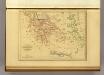
Grece et de l'Archipel.
1 : 2650000 Malte-Brun, Conrad, 1775-1826