Maps of Diego Garcia Naval Support Facility

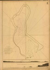
Plan of the Harbour at the Island Chagos or Diego Garcia
Plan of the Harbour at the Island Chagos or Diego Garcia ... from a survey ... by Lieut. A. Blair. Includes two views of the island of Chagos [Admiralty Chart] [London]
Diego Garica from entrance to East Point.
Diego Garcia from entrance to East Point. Surveyed by Commr. F.C.P. Vereker ... 1885. Natural Scale, 1 : 24,188. (Southern portion. Natural Scale, 1 : 72,560.) [Admiralty Chart] London
Charte von Zanguebar der Kafferküste und der Insel Madagascar : nach den neuesten und besten Hülfsmitteln
1 : 6800000 Reinecke, J. C. M. (Johann Christoph Matthias), 1770-1818 Im Verlag des Industrie Comptoirs
Indes II.
1 : 10000000 Bonne, Rigobert, 1727-1794
Uebersichts-Karte der ethnographischen Verhältnisse von Asien und von den angrenzenden Theilen Europa'sbearbeitet und herausgegeben mit Unterstützung der kaiserlichen Akademie der Wissenschaften in Wien von Vinzenz v. Haardt
Hartenthurn, Vincenz
Oost-Indië : voor de zending bewerkt / door L. Kupérus
1 : 5000000 Annotatie geografische gegevens: Legenda; Inzet: Noord-Halmahera (Utr. Zend. Verg.); Rijnsche Zend. Gen., Java-Comité en Ned. Zend. Gen. in de Bataklanden en Deli (Sumatra); Ambonsche eilanden en Zuid-West Ceram; Talauer eilanden; De Minahasa; Ressort Roon; Sangi Eilanden; Bijkrt.: Java. - 1:1.000.000. - Inzet: Batavia en omgeving Amsterdam : Seyffardt's Boekhandel / (Amsterdam : Senefelder)
Arabian Sea.
1 : 10000000 Philip, George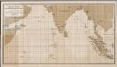
[Azië], uit: Routekaart van Nederland naar Ned. Indië en terug
1 : 8000000 Annotatie: Samengest. op uitnoodiging der Stoomvaart Maatschappij Nederland Groustra, J. Amsterdam : Seyffardt
Ostindien
Asie jižní im Verlage des Kunst u. Industrie Comptoirs
Undecima Asiae Tabula [Karte], in: Claudii Ptolemei viri Alexandrini mathematice discipline philosophi doctissimi geographie opus [...], S. 223.
1 Karte aus Atlas Waldseemüller, Martin [und Ptolemaeus, Claudius] Übelin, Georg
Ost Indien
Stieler's Hand-Atlas Stieler, Adolf bei Justus Perthes
Ost Indien mit besonderer Berücksichtigung der englischen Besitzungen
Geographischer Atlas über alle Theile der Erde Ziegler, Jakob Melchior Verlag von Dietrich Reimer
Islands In The Indian Ocean (with) inset map of Mauritius.
1 : 23760000 Tallis, J. & F.
CARTE DES INDES ORIENTALES
1 : 10700000 Asie jihovýchodní Mayer, Tobias Apres de Mannevillette, Jean-Baptiste-Nicolas-Denis d' Heritiers de Homan[n]
Ostindien.
1 : 22000000 Reichard, C. G.
India
1 : 19000000 Asie jihovýchodní Spruner, Karl von Justus Perthes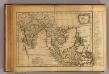
Les Indes Orientales.
1 : 29000000 Lattre, Jean
Ost-Indien mit den Inseln
Hand-Atlas über alle Theile der Erde nach dem neuesten Zustande und über das Weltgebäude Stieler, Adolf bei Justus Perthes
Ostindien mit den Inseln
Schul-Atlas über alle Theile der Erde nach dem neuesten Zustande, und über das Weltgebäude Stieler, Adolf bei Justus Perthes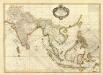
Composite: Indes.
1 : 10000000 Bonne, Rigobert, 1727-1794
Ostindien
Neuester Schul-Atlas Walch, Johann im Verlag bei Joh. Walch
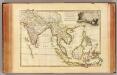
Indes Orientales.
1 : 16250000 Bonne, Rigobert, 1727-1794
Ost-Indien
Handatlas über alle Theile der Erde und über das Weltgebäude Stieler, Adolf Justus Perthes
Ostindien
Allgemeiner Atlas [Walch, Johannes] im Verlag bei Johannes Walch
Ost-Indien mit den Inseln
Hand-Atlas über alle Theile der Erde nach dem neuesten Zustande und über das Weltgebäude Stieler, Adolf bei Justus Perthes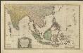
Carte des Indes Orientales
1 : 10000000 dessinée suivant les observations les plus recentes, dont le principal est tirée des cartes hydrographiques de Mr. D'Apres de Mannevillette dediée tres humblement à [...] Guillaume Charles Henry Friso [...] par [...] l'auteur et les Heritiers de Homan(n) ; S. Dorn fe. [Nürnberg] : Heritiers de Homann
Ost-Indien
Hand-Atlas über alle Theile der Erde und über das Weltgebäude Stieler, Adolf Justus Perthes
Ostindien und China
1 : 25000000 Himálaj Kocen, Blaž Eduard Hölzel