Maps of Queen Maud Land
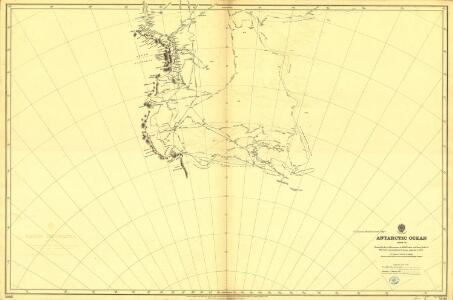
Antarctic Ocean (1901)
Antarctic Ocean. Sheet VIII. Shewing Tracks and Discoveries of H.M.S. Erebus and Terror" 1841-42. With Tracks and amendments ... to 1900." London : Admiralty
Bunnen av Weddell Havet
1 : 2700000 Antarktický oceán Norges geogr. opmaling
Spesielle kart 84a: Kart over "Antarktis" - Prinsesse Ragnhild land
1 : 500000 H. E. Hansen
Spesielle kart 84b: Kart over "Antarktis" - Prins Harald land
1 : 250000 H. E. Hansen
Spesielle kart nr 84k: Kart over "Antarktis" -Ingrid Christensen land
1 : 250000 H. E. Hansen
Spesielle kart 81j: Ingrid Christensen land
1 : 250000 Bernhard Luncke | H. E. Hansen NGO
Spesielle kart nr 84j: Kart over ""Antarktis"" - Ingrid Christensen land"
1 : 250000 H. E. Hansen
Spesielle kart 81k: Ingrid Christensen land
1 : 250000 Bernhard Luncke | H. E. Hansen NGO
Spesielle kart nr 84i: Kart over "Antarktis" - Lars Christensen land
1 : 250000 H. E. Hansen
Spesielle kart 84g: Kart over "Antarktis" - Lars Christensen land
1 : 250000 H. E. Hansen
Spesielle kart nr 84l: Kart over "Antarktis" - Kong Leopold og Dronning Astrid land
1 : 250000 H. E. Hansen
Spesielle kart 84h: Kart over "Antarktis" - Las Christensen land
1 : 250000 H. E. Hansen
Spesielle kart 84f: Kart over "Antarktis" - Mac-Robertson land
1 : 250000 H. E. Hansen
Facies Poli Antarctici
1 : 34000000 Antarktida Weigel, Christoph
Chica sive Patagonica et avstralis terra
1 Karte : Kupferdruck ; Bildgrösse 22 x 28 cm Quad Johannes Bussemacher
South Polar regions.
1 : 14000000 John Bartholomew and Son
Southern Regions.
1 : 22176000 Colton, G.W.
Spesielle kart 84e: Kart over "Antarktis" - Kemp land
1 : 250000 H. E. Hansen
Arctic Ocean. Antarctica. Pacific Ocean.
1 : 31149000 Hammond, C.S.
Antarctica, VICTORIA LAND, Ross Dependency (South)
Antarctica. Part of Victoria Land. Based on ground surveys carried out by the Trans Antarctic Expedition 1957-58, Victoria University of Wellington Antarctic Expeditions 1958-59, 1959-60, and the New Zealand Geological & Survey Antarctic Expedition 1958-59. Further detail from United States aerial photography. Provisional edition 1 Mar 1961. N.Z.M.S. 175/3. Polar stereographic projection. 1 : 250,000 at 71 -- Wellington : Lands & Survey Dept.
Antarctica, VICTORIA LAND, Ross Dependency (North)
Antarctica. Part of Victoria Land. Based on ground surveys carried out by the Trans Antarctic Expedition 1957-58, Victoria University of Wellington Antarctic Expeditions 1958-59, 1959-60, and the New Zealand Geological & Survey Antarctic Expedition 1958-59. Further detail from United States aerial photography. Provisional edition 1 Mar 1961. N.Z.M.S. 175/3. Polar stereographic projection. 1 : 250,000 at 71 -- Wellington : Lands & Survey Dept.
Terres Australes.
1 : 60000000 L'Isle, Guillaume de, 1675-1726
Sudpolarregion, Polynesische Inselgruppen.
Andree, Richard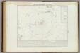
Carta generale del Polo Antartica
1 : 22500000 Marzolla, Benedetto
Sud-Polar-Karte. (Maasfstab 1:40,000,000).
1 : 40000000 Petermann, A.
Sud-Pol.
1 : 50000000 Meyer, Joseph, 1796-1856
Süd-Polar-Karte
1 : 40000000 Antarktida Petermann, August Habenicht, Hermann Justus Perthes
Carte des terres australes, comprises entre le tropique du Capricorne et le pôle antarctique
1 Karte : Kupferdruck ; Durchmesser 24 cm, Blattgrösse 47 x 62 cm Buache; Bouvet de Lozier; Delahaye Philippe Buache
[Südpolgebiet]
1 Karte : Kupferdruck ; Durchmesser 42 cm, Bildgrösse 43 x 49 cm Valck; Schenk apud G Valk et P Schenk