Maps of Northwest
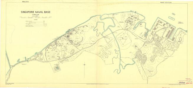
Singapore Naval Base
This map, published in 1944, shows the Singapore Naval Base in 1942. British-held Singapore fell to the Japanese 15 Feb 1942, and was not liberated until 5 Sept 1945. This plan was compiled and drawn from Admiralty charts and corected to 1942. GSGS Misc 198. Great Britain. Inter-service Topographical Dept. London : War Office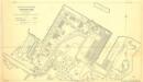
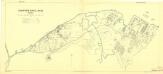
H.M. Naval Base, Singapore. Dockyard area as at January 1942.
This map, published in 1944, shows the docks and naval yard in 1941-2 Singapore. British-held Singapore fell to the Japanese 15 Feb 1942, and was not liberated until 5 Sept 1945. The map was created from a drawing 30 June 1941, with amendments to Jan 1942 using information received to the UK to 1944. GSGS Misc 196. Great Britain. Inter-service Topographical Dept. London : War Office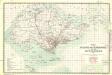
Singapore and its dependencies [Map of the isle] (1911)
Map of the island of Singapore and its dependencies, GSGS 2609. Great Britain. General Staff. Geographical Section. [London] : [GSGS, War Office]
Singapore / published under the direction of the Chief of Engineers U.S. Army by the Army Map Service
Army Map Service U.S. Army Washington D.C. Washington D.C. : Army Map Service
[Batam]
Topografische Dienst Batavia Batavia : Reproductiebedrijf Topografische Dienst
Strait of Singapore / Survey of India
Survey of India [S.l.] : Survey of India
Riouw Archipelago : 1 inch to 1 mile / S[u]rv[e]y Directorate H[ead] Q[uarters] ALFSEA
[S.l. : s.n.]
[Lingga-Archipel]
Topografische Dienst Batavia Batavia : Reproductiebedrijf Topografische Dienst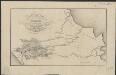
Figurative kaart van een gedeelte van Sumatra voornamelijk aantoonende de wegen en rivieren, welke uit de Padangsche binnenlanden naar de oostkust afloopen
1 : 1360000 opgenomen door S. Muller en H. Hellbach steendr. van H.J. Backer Amsterdam : Beyerinck
Singapore / Survey of India
Survey of India [S.l.] : Survey of India
Routekaart Pakanbaroe - Batavia
[S.l. : s.n.
British Possessions In The Indian Seas.
Fullarton, A. & Co.
Bladwijzer van Oost-Sumatra : 1:100.000
[S.l. : s.n.]
Kaart van Midden-Sumatra : Gouver.nt v. Sumatra's Westkust, Zuid ged. d. R. Sumatra's-Oostkust, Afd. Lingga v.d. Res. Riouw en Onderh. en het Rijk Djambi/ [J.W. Stemfoort en J.J. ten Siethoff ; gereproduceerd op last van het Departement van Koloniën, aan de Topographische Inrichting te 's-Gravenhage, onder leiding van den Directeur C.A. Eckstein]
Ministerie van Koloniën Den Haag s-Gravenhage : Departement van Koloniën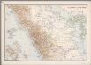
7. Midden-Sumatra, uit: Atlas van Nederlandsch Oost-Indië / samengest. door Topographisch Bureau te Batavia van 1897-1904
Annotatie: Omgewerkte versie van: Atlas der Nederlandsche bezittingen in Oost-Indië / naar de nieuste bronnen samengest. door J.W. Stemfoort en J.J. ten Siethoff. - 's-Gravenhage : Topographische Inrichting, [ca. 1885] Topographisch Bureau, Batavia 's-Gravenhage : Topographische Inrichting
Geologische overzichtskaart van het schiereiland Malakka en omgeving = Geological map of British Malaya / J.B. Scrivenor
Landsdrukkerij Batavia [Weltevreden (Batavia) : Landsdrukkerij]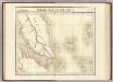
Presqu'ile de Malacca. Oceanique no. 12.
1 : 1641836 Vandermaelen, Philippe, 1795-1869
Overzichtskaart van den weg Medan-Padang / samengest. door de Deli Automobiel Club
Deli Automobiel Club Medan [Medan] : Deli Automobiel Club
Overzichtskaart van den weg Medan-Padang / samengesteld door den Deli Automobiel Club
Deli Automobiel Club Medan [Medan] : Deli Automobiel Club
Sumatra North
Survey India Offices (H.L.O.) [S.l.] : Survey India Offices (H.L.O.)
Automobielkaart van Zuid-Sumatra / samengesteld en uitgegeven door de Koninklijke Vereeniging Java Motor Club
Koninklijke Vereeniging Java Motor Club Semarang Semarang : Koninklijke Vereeniging Java Motorclub
Overzichtskaartje Midden-Sumatra / Top[ografische] D[ienst]
Topografische Dienst Weltevreden (Batavia) Welt[evreden] (Batavia) : Repr[oductie] Bedr[ijf] Top[ografische] D[ienst]
Automobielkaart van Noord-Sumatra / samengesteld en uitgegeven door de Koninklijke Vereeniging Java Motor Club
Koninklijke Vereeniging Java Motor Club Semarang Semarang : Koninklijke Vereeniging Java Motorclub
Figuratieve schets van het Gouvernement Sumatra's Westkust tot 1830 / door H. de S.

To Captain Samuel Ashmore, in acknowledgement of much valuable information given, elucidative of oriental navigation, and of the western coast of Sumatra in particular
1 : 1800000 this chart is inscribed by James Horsburgh engraved by J. & C. Walker [London] : J. Horsburgh
Overzichtskaart van het eiland Sumatra : met aanduiding van de politieke indeeling, de organisatie van het bestuur, de bestaande en nog aan te leggen verkeerswegen, de groote cultuur- en industrieele centra en van de vindplaatsen van mineralen / samengest. op last van de N.I. Regeering [door de Topographische Inrichting]
Topographische Inrichting Batavia Batavia : Topographische Inrichting
Economische overzichtskaart van het eiland Sumatra / samengesteld bij den Topografischen Dienst
Topografische Dienst, Nederlandsch-Indië Batavia : Top. Inr. Bat.