Maps of Tower Hamlets

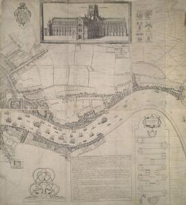
Newcourt's 'Map of London', detail showing the East End
Richard Newcourt’s map, made in 1658, represents the first complete survey of London since the 1550s. It shows the City and its surrounding countryside in the closing years of the Commonwealth. Though most buildings are depicted in a conventionalised way, the map gives some idea of the actual appearance of more important places, such as churches and livery halls. The inclusion of their coats of arms in the map's decoration suggests the Livery Companies may have commissioned Newcourt's work. The map provides a fairly accurate picture of the development of the City's eastern suburbs, already spreading along the roads that reached out across the countryside towards the surrounding villages. As well as being the docklands of London, this was the area where the first native English school of chartmaking, the so-called 'Thames School', was getting underway at the very time this map was made. Newcourt, Richard
London VII.SE - OS Six-Inch Map
1 : 10560 Topographic maps Ordnance Survey Ordnance Survey
Surrey III.NE - OS Six-Inch Map
1 : 10560 Topographic maps Ordnance Survey Ordnance Survey
The Jew in London. A study of racial character and present-day conditions.
Arkill, G.E. T. Fisher Unwin
Insurance Plan of London Vol. XI: Key Plan
1 : 4800 This "key plan" indicates coverage of the Goad 1890 series of fire insurance maps of London that were originally produced to aid insurance companies in assessing fire risks. The building footprints, their use (commercial, residential, educational, etc.), the number of floors and the height of the building, as well as construction materials (and thus risk of burning) and special fire hazards (chemicals, kilns, ovens) were documented in order to estimate premiums. Names of individual businesses, property lines, and addresses were also often recorded. Together these maps provide a rich historical shapshot of the commercial activity and urban landscape of towns and cities at the time. The British Library holds a comprehensive collection of fire insurance plans produced by the London-based firm Charles E. Goad Ltd. dating back to 1885. These plans were made for most important towns and cities of the British Isles at the scales of 1:480 (1 inch to 40 feet), as well as many foreign towns at 1:600 (1 inch to 50 feet). Chas E Goad Limited Chas E Goad Limited
A new and exact plan of the city of London and suburbs thereof, 3
1 Blatt : 58 x 50 cm Henry Overton
Insurance Plan of London: sheet 8
This detailed 1889 plan of London is one of a series of six sheets in an atlas originally produced to aid insurance companies in assessing fire risks. The building footprints, their use (commercial, residential, educational, etc.), the number of floors and the height of the building, as well as construction materials (and thus risk of burning) and special fire hazards (chemicals, kilns, ovens) were documented in order to estimate premiums. Names of individual businesses, property lines, and addresses were also often recorded. Together these maps provide a rich historical shapshot of the commercial activity and urban landscape of towns and cities at the time. The British Library holds a comprehensive collection of fire insurance plans produced by the London-based firm Charles E. Goad Ltd. dating back to 1885. These plans were made for most important towns and cities of the British Isles at the scales of 1:480 (1 inch to 40 feet), as well as many foreign towns at 1:600 (1 inch to 50 feet). Chas E Goad Limited Chas E Goad Limited
Insurance Plan of London Vol. V: Key Plan 3
1 : 480 This detailed 1887 plan of London is one of a series of twenty-five sheets in an atlas originally produced to aid insurance companies in assessing fire risks. The building footprints, their use (commercial, residential, educational, etc.), the number of floors and the height of the building, as well as construction materials (and thus risk of burning) and special fire hazards (chemicals, kilns, ovens) were documented in order to estimate premiums. Names of individual businesses, property lines, and addresses were also often recorded. Together these maps provide a rich historical shapshot of the commercial activity and urban landscape of towns and cities at the time. The British Library holds a comprehensive collection of fire insurance plans produced by the London-based firm Charles E. Goad Ltd. dating back to 1885. These plans were made for most important towns and cities of the British Isles at the scales of 1:480 (1 inch to 40 feet), as well as many foreign towns at 1:600 (1 inch to 50 feet). Chas E Goad Limited Chas E Goad Limited
Vrbium Londini et West-Monasterii nec non suburbii Southwark accurata ichnographia, 2
1 Blatt : 52 x 62 cm Homännische Erben
Vrbium Londini et West-Monasterii nec non suburbii Southwark accurata ichnographia, 3
1 Blatt : 53 x 57 cm Homännische Erben
Insurance Plan of London: sheet 7
This detailed 1889 plan of London is one of a series of six sheets in an atlas originally produced to aid insurance companies in assessing fire risks. The building footprints, their use (commercial, residential, educational, etc.), the number of floors and the height of the building, as well as construction materials (and thus risk of burning) and special fire hazards (chemicals, kilns, ovens) were documented in order to estimate premiums. Names of individual businesses, property lines, and addresses were also often recorded. Together these maps provide a rich historical shapshot of the commercial activity and urban landscape of towns and cities at the time. The British Library holds a comprehensive collection of fire insurance plans produced by the London-based firm Charles E. Goad Ltd. dating back to 1885. These plans were made for most important towns and cities of the British Isles at the scales of 1:480 (1 inch to 40 feet), as well as many foreign towns at 1:600 (1 inch to 50 feet). Chas E Goad Limited Chas E Goad Limited
Insurance Plan of London Vol. xi Regent's Canal and Vicinity: Key Plan 3
1 : 4800 This "key plan" indicates coverage of the Goad 1891 series of fire insurance maps of London that were originally produced to aid insurance companies in assessing fire risks. The building footprints, their use (commercial, residential, educational, etc.), the number of floors and the height of the building, as well as construction materials (and thus risk of burning) and special fire hazards (chemicals, kilns, ovens) were documented in order to estimate premiums. Names of individual businesses, property lines, and addresses were also often recorded. Together these maps provide a rich historical shapshot of the commercial activity and urban landscape of towns and cities at the time. The British Library holds a comprehensive collection of fire insurance plans produced by the London-based firm Charles E. Goad Ltd. dating back to 1885. These plans were made for most important towns and cities of the British Isles at the scales of 1:480 (1 inch to 40 feet), as well as many foreign towns at 1:600 (1 inch to 50 feet). Chas E Goad Limited Chas E Goad Limited
Insurance Plan of London: sheet 4
This detailed 1889 plan of London is one of a series of six sheets in an atlas originally produced to aid insurance companies in assessing fire risks. The building footprints, their use (commercial, residential, educational, etc.), the number of floors and the height of the building, as well as construction materials (and thus risk of burning) and special fire hazards (chemicals, kilns, ovens) were documented in order to estimate premiums. Names of individual businesses, property lines, and addresses were also often recorded. Together these maps provide a rich historical shapshot of the commercial activity and urban landscape of towns and cities at the time. The British Library holds a comprehensive collection of fire insurance plans produced by the London-based firm Charles E. Goad Ltd. dating back to 1885. These plans were made for most important towns and cities of the British Isles at the scales of 1:480 (1 inch to 40 feet), as well as many foreign towns at 1:600 (1 inch to 50 feet). Chas E Goad Limited Chas E Goad Limited
London (1915- Numbered sheets) V.12 (includes: Bermondsey; Stepney) - 25 Inch Map
1 : 2500 Topographic maps Ordnance Survey Ordnance Survey
London (First Editions c1850s) XXXVII (includes: Bermondsey; Stepney) - 25 Inch Map
1 : 2500 Topographic maps Ordnance Survey Ordnance Survey
A MAP OF THE PARISH OF ST. MARY ROTHERHITH
1 : 4800 This plan was first published in Strype's 1720 annotated edition of Stow's 'Survey of England'. The title appears along the top, with compass rose, scale bar and table of reference in the centre. Damaged by repeated flooding, the old medieval parish church of St. Mary was demolished at the beginning of the 18th Century. In 1715, a new parish church was erected on the site with funds raised by the parishioners themselves after the commissioners of the Fifty New Churches Act turned down their request for money. Harris, J.
Insurance Plan of London Vol. V: Key Plan 1
1 : 480 This "key plan" indicates coverage of the Goad 1887 series of fire insurance maps of London that were originally produced to aid insurance companies in assessing fire risks. The building footprints, their use (commercial, residential, educational, etc.), the number of floors and the height of the building, as well as construction materials (and thus risk of burning) and special fire hazards (chemicals, kilns, ovens) were documented in order to estimate premiums. Names of individual businesses, property lines, and addresses were also often recorded. Together these maps provide a rich historical shapshot of the commercial activity and urban landscape of towns and cities at the time. The British Library holds a comprehensive collection of fire insurance plans produced by the London-based firm Charles E. Goad Ltd. dating back to 1885. These plans were made for most important towns and cities of the British Isles at the scales of 1:480 (1 inch to 40 feet), as well as many foreign towns at 1:600 (1 inch to 50 feet). Chas E Goad Limited Chas E Goad Limited
A MAP OF THE PARISH OF ST. MARY ROTHERHITH.
1 : 4800 This plan was first published in Strype's 1755 edition of Stow's 'Survey of England'. The title appears along the top with compass rose, scale bar and table of reference in the centre. Damaged by repeated flooding, the old medieval parish church of St. Mary was demolished at the beginning of the 18th Century.In 1715, a new parish church was erected on the site with funds raised by the parishioners themselves after the commissioners of the Fifty New Churches Act turned down their request for money. Blome, Richard
St. MARY, WHITE CHAPEL and St. JOHN; WAPPING Parish taken from y.e last Survey with Corrections and Additions
1 : 5400 Plan of the parishes of St. Mary, White Chapel and St. John, Wapping published in Strype's 1755 edition of Stow's "Survey of England". The plan features title, in cartouche, compass and key to places in the parishes down the right side of the plate and scale bar at lower left. Blome, Richard
Insurance Plan of London Vol. XI: Key Plan
1 : 480 This detailed 1899 plan of London is one of a series of twenty-eight sheets in an atlas originally produced to aid insurance companies in assessing fire risks. The building footprints, their use (commercial, residential, educational, etc.), the number of floors and the height of the building, as well as construction materials (and thus risk of burning) and special fire hazards (chemicals, kilns, ovens) were documented in order to estimate premiums. Names of individual businesses, property lines, and addresses were also often recorded. Together these maps provide a rich historical shapshot of the commercial activity and urban landscape of towns and cities at the time. The British Library holds a comprehensive collection of fire insurance plans produced by the London-based firm Charles E. Goad Ltd. dating back to 1885. These plans were made for most important towns and cities of the British Isles at the scales of 1:480 (1 inch to 40 feet), as well as many foreign towns at 1:600 (1 inch to 50 feet). Chas E Goad Limited Chas E Goad Limited
London (1915- Numbered sheets) V.16 (includes: Bermondsey; Poplar Borough) - 25 Inch Map
1 : 2500 Topographic maps Ordnance Survey Ordnance Survey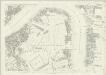
London (First Editions c1850s) XLVI (includes: Bermondsey; Poplar Borough) - 25 Inch Map
1 : 2500 Topographic maps Ordnance Survey Ordnance Survey
A Map of the Parish of St. Dunstans Stepney, als. Stebunheath.
A. Churchill
THE PARISH of ST. JOHNS WAPPING. The Parish of ST. PAUL SHADWELL
Plan in two sections representing the parishes of St. John, Wapping and St. Paul's, Shadwell published in Strype's 1720 annotated edition of Stow's "Survey of England". The plan features title along the top, key to streets, courts, churches etc. in both parishes at upper left and lower right, compass at lower left and scale bar at bottom right. Blome, Richard
Insurance Plan of London Vol. VII: sheet 172-1
1 : 480 This detailed 1887 plan of London is one of a series of twenty-six sheets in an atlas originally produced to aid insurance companies in assessing fire risks. The building footprints, their use (commercial, residential, educational, etc.), the number of floors and the height of the building, as well as construction materials (and thus risk of burning) and special fire hazards (chemicals, kilns, ovens) were documented in order to estimate premiums. Names of individual businesses, property lines, and addresses were also often recorded. Together these maps provide a rich historical shapshot of the commercial activity and urban landscape of towns and cities at the time. The British Library holds a comprehensive collection of fire insurance plans produced by the London-based firm Charles E. Goad Ltd. dating back to 1885. These plans were made for most important towns and cities of the British Isles at the scales of 1:480 (1 inch to 40 feet), as well as many foreign towns at 1:600 (1 inch to 50 feet). Chas E Goad Limited Chas E Goad Limited
London (1915- Numbered sheets) V.11 (includes: Bethnal Green; London; Shoreditch; Stepney) - 25 Inch Map
1 : 2500 Topographic maps Ordnance Survey Ordnance Survey
A Correct Plan of the London Docks
Plan of the London Docks with title along the top and imprint, key and reference table in panel below the plan. The boundaries of the area granted by act of Parliament in 1800 for redevelopment are highlighted in red. Fairburn, John
Plan of Proposed London Docks (at Wapping)
The number of ships using the Port of London had risen steadily throughout the 18th century. Yet the riverside quays were still those first licensed in 1558. In 1793, the decision was taken to ease the congestion by digging deep-water basins where ships could be moored in more secure and controlled circumstances. Plans were ordered for wet docks in Wapping, the Isle of Dogs and Rotherhithe. Daniel Alexander was charged with devising the scheme for the proposed London Docks at Wapping, a 35 acres site that would hold 500 ships. This plan, published in 1799, shows the many streets and squares that would be lost to the new docks - more than half of Wapping south of Pennington Street. The following year, Parliament passed the London Dock Act and details were published of the land and properties destined for compulsory purchase. Names of the owners and tenants are listed, together with the length of their notice to quit. Alexander, Daniel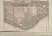
Plan of the Proposed DOCKS
1 : 6336 This is Daniel Alexanders original design for the London Docks. Commissioned by the House of Commons, the plan's title is at bottom left with scale bars to bottom right. An explanatory note appears in panel below the plan. Alexander's original design included a 20-acre St. Georges Dock to the west and a seven-acre Shadwell Dock to the east. Both would have their own basins, and be linked by a small Tobacco Dock. Opened in 1805, London Docks were the nearest to the city and for 21 years all imports of tobacco, rice, wine and brandy (except those from the East and West Indies) had to unload there. Alexander, Daniel