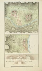
Maps of Palamu

Nos. 8-10. Palamow Fort, Agowry Fort, Ancient Hindoo Temples at Marra in Singrowla. From a series of plans of forts and passes on the W. border of Bihar, copied from the original by Lieut Robert Smith
Pen-and-ink and water-colour plans of the forts at Agori and Palamau and of Hindu Temples at Marra after Robert Smith (1787-1873), c.1813. This is one of six plans of forts and passes on the west border of Bihar. Inscribed on the front of the folder in ink is: 'Plans of Forts & Passes on the South West Frontier of Bengal. Copied from the Original by Lieut. Robt. Smith of the Engineers.' There are two large forts at Palamau said to have been built by the Adivasi kings of the Chero dynasty. Construction of the forts was begun by Raja Medhni Raj, the ruler of Chotanagpur, however they were completed by his son Pratap Raj while Medhni Raj was engaged with repelling invaders. The main fort has three main defences, the largest of which is named Singh Dwar or Lion Gate. The Nagpuri Gate bears two inscriptions in Sanskrit and Persian. Smith, Robert (1787-1873), Artist
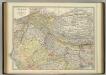
Gold, copper and lead in Chota Nagpore
This is the map contained within the 176-page volume Gold, copper and lead in Chota Nagpore and the adjacent country, compiled by W. King and T.A. Pope and published in Calcutta. King, W., F.G.S. (William) Calcutta : Thacker, Spink
(Bengal, Bahar &c north)
1 : 750000 Robert Laurie & James Whittle
India 7.
1 : 2217600 Letts, Son & Co.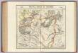
Malwa, Berar et Beeder. Asie 94.
1 : 1641836 Vandermaelen, Philippe, 1795-1869
India VII.
1 : 2200000 Society for the Diffusion of Useful Knowledge (Great Britain)
Composite: Delhi, Agrah, Oude, Ellahabad.
1 : 750000 Robert Laurie & James Whittle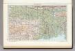
142. Lower Ganga (Ganges) Valley. The World Atlas.
1 : 2500000 USSR (Union of Soviet Socialist Republics).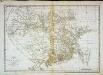
Carte du Bengale et de ses dépendances
1 Karte : Kupferdruck ; 37 x 53 cm Bolts s.n.
North-Western Provinces, Oudh, and Nepal.
1 : 3990000 W. & A.K. Johnston Limited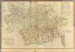
Composite: Bengal, Bahar &c.
1 : 750000 Robert Laurie & James Whittle
Bengal Etc.
1 : 3380000 Sharpe, J.
Provinces of the Lower Ganges.
1 : 2000000 John Bartholomew & Co.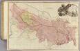
Bengal, Bahar, Oude, Allahabad.
1 : 1480000 Rennell, James, 1742-1830
Gangetic Hindoostan or the countries occupied by the Ganges and the branches
1 : 7000000 Cary, John, ca. 1754-1835 J. Cary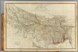
N. Hindostan.
1 : 1480000 Robert Laurie & James Whittle
Central division of Hindoostan
1 : 7000000 Cary, John, ca. 1754-1835 J. Cary
Sheet C [North East India], uit: Road map of India
1 : 2027520 titelvariant: North West India; Central & North India; North East India; South India; Annotatie geografische gegevens: De bladen overlappen elkaar gedeeltelijk; Elk blad met bladoverzicht van de hele serie [S.l. : India Tyre & Rubber Company]

Map of the East Indian Railway

India - southern section.
1 : 4000000 John Bartholomew & Co.
140-141. South India, Ceylon, Burma. The World Atlas.
1 : 5000000 USSR (Union of Soviet Socialist Republics).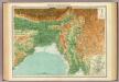
India - north-eastern section.
1 : 4000000 John Bartholomew & Co.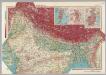
India - North. Pergamon World Atlas.
1 : 5000000 Polish Army Topography Service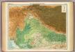
India - north-western section.
1 : 4000000 John Bartholomew & Co.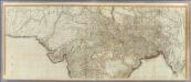
(Hindoostan north)
1 : 2500000 Robert Laurie & James Whittle
Carte de l'Inde. (Northern section).
1 : 3100000 Anville, Jean Baptiste Bourguignon d, 1697-1782
Northern India Including The Presidency of Calcutta.
1 : 9000000 Tallis, J. & F.
[Undecima Asie tabula] [Karte], in: Clavdii Ptholomei Viri Alexandrini Cosmographie, S. 188.
1 Karte aus Atlas Nicolaus Germanus [und Ptolemaeus, Claudius]