Maps of Kensington and Chelsea

Knighsbridge showing Hyde Park
Hyde Park is shown hereon the north side of the turnpike road. The largest of all the Royal parks, extending over 340 acres of land, Hyde Park was originally a hunting ground for deer, boars and wild bull. Bequeathed to the monks of Westminster after the conquest of Geoffrey de Mandeville in the 1140s, the park was appropriated by Henry VIII at the dissolution of the monasteries in 1536. The park was opened to the public at the beginning of the 17th century and deer were hunted there until 1768. Salway, Joseph
Knightsbridge, 1 Mile from Hyde Park Corner
Gray's Nursery and Seed Shopis depicted in plan form on the south side of this stretch of Knightsbridge, next to property belonging to James Vere. A milestone on the north side of the road indicates a distance ofone mile to Hyde Park Corner, where the toll road terminated. Salway, Joseph
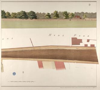
Knightsbridge showing the Halfway House
The Halfway House is depicted in plan and elevation on the north side of the road on the site of today's Prince of Wales Gate. This ancient inn, with its ramshackle stables and pigsties, had long been popular with highwaymen in the area. Salway, Joseph
London VI.90 - OS London Town Plan
1 : 1056 Topographic maps Ordnance Survey Ordnance Survey
Plan of Estates IN THE PARISHES OF KENSINGTON AND ST MARGARET'S WESTMINSTER IN THE COUNTY OF MIDDLESEX Purchased by HER MAJESTY'S COMMISSIONERS for the EXHIBITION OF 1851.
1 : 4800 The site in South Kensington depicted in green on this plan was purchased by the Queen's Commissioners to host the Great Exhibition of 1851. The title, key to colours, compass star and scale bar appear down the left side of the plate. The boundaries of the four properties comprising the commissioners' estate are outlined as follows: Gore House in blue, Villar in red, Harrington in yellow and the Smith's Charity Estate in brown. Day & Son
Plan Generale du Palais & Jardins de Kensington Situe dans la Conte de Middlesex a 2 miles de Londres tres Exactement Leve dessiene & Grave par Jean Rocque 1736
1 : 2400 On this plan of Kensington Palace and gardens, the key is at bottom left, with title and dedication at bottom centre, and scale bar at bottom left. The Kensington Gardens were originally attached to Nottingham House, which was bought in 1689 by William III and turned into Kensington Palace. Queen Mary took a great interest in the gardens and had them landscaped by royal gardeners in formal Dutch patterns. Uprooted by order of Queen Anne at the beginning of the 18th century, the Dutch gardens were replaced in 1726 by this Wise and Bridgeman design, which included the round pond, the Broad Walk and the Temple Lodge. Rocque, John
MILITARY SKETCH OF HYDE PARK
This plan shows the barracks along Knightsbridge erected for the Horse Guard at the end of the 18th century. The title appears at lower left, below the scale bar. At over 340 acres the largest of the royal parks, Hyde Park was originally a hunting ground for deer, boars and wild bull. Bequeathed to the monks of Westminster after the conquest of Geoffrey de Mandeville in the 1140s, the park was appropriated by Henry VIII at the dissolution of the monasteries in 1536. The park was opened to e public at the beginning of the 17th century and remained a deer-hunting ground until 1768. Baker, B.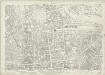
London (1915- Numbered sheets) IV.16 (includes: City Of Westminster; Kensington; Paddington) - 25 Inch Map
1 : 2500 Topographic maps Ordnance Survey Ordnance Survey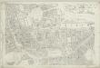
London (First Editions c1850s) XLII (includes: City Of Westminster; Kensington; Paddington) - 25 Inch Map
1 : 2500 Topographic maps Ordnance Survey Ordnance Survey
PLAN OF HYDE PARK as it was in 1725
1 : 792 This retrospective plan of Hyde Park was produced from an earlier plan held in the Vestry Room in St George's Church, Hanover Square. Its title features at top right, with the scale bar at top left. At over 340 acres of land the largest of all the royal parks, Hyde Park was originally a hunting ground for deer, boars and wild bull. Bequeathed to the monks of Westminster after the conquest of Geoffrey de Mandeville in the 1140s, the park was appropriated by Henry VIII at the dissolution of the monasteries in 1536. The park was opened to the public at the beginning of the 17th century, and remained a deer hunting ground until 1768. Neele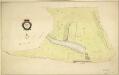
HYDE PARK
1 : 3960 The title and compass star of this plan appear at middle left, with them scale bar at bottom right. At over 340 acres the largest of all the royal parks, Hyde Park was originally a hunting ground for deer, boars and wild bull. Bequeathed to the monks of Westminster after the conquest of Geoffrey de Mandeville in the 1140s, the park was appropriated by Henry VIII at the dissolution of the monasteries in 1536. The park was opened to the public at the beginning of the 17th century, and remained a deer hunting ground until 1768. Bennett, S.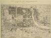
A Plan of the Palace Gardens and TOWN of KENSINGTON
1 : 4800 The title of this plan of Kensington Palace and gardens appears in English and French, with scale bars and a key to architectural and natural features, in a panel below the plan. Kensington Gardens were originally attached to Nottingham House, which was bought in 1689 by William III and turned into Kensington Palace. Queen Mary took a great interest in the gardens and had them landscaped by royal gardeners in formal Dutch patterns. Uprooted by order of Queen Anne at the beginning of the 18th century, the Dutch gardens were replaced in 1726 by this Wise and Bridgeman design, including the round pond, the Broad Walk and the Temple Lodge. Rocque, John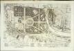
A plan of the palace gardens and town of Kensington
1 Plan : Kupferdruck ; 28 x 48 cm Rocque; Deharme John Rocque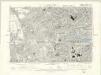
London VI.SE - OS Six-Inch Map
1 : 10560 Topographic maps Ordnance Survey Ordnance Survey
Plan of the Parish of PADDINGTON in the County of Middlesex 4
1 : 9600 The title, imprint and compass rose of this plan appear at top right with scale bars at the foot of the plate. It is accompanied by handwritten note with key to land acquired by the Grand Junction Canal Company from the Bishop of London(depicted in red) with the proposed new roads into the Bishop's estate.These roads are represented by a brown double-dotted line and were added by the surveyor Ralph Samuel Cockrell. With Cockrell's additions, this plan was presented to the Commissioners of Sewers for consultation on the best way to lay out a sewage and draining system in the area. Gutch, George
Plan of the parish of PADDINGTON in the County of Middlesex 6
The development of Paddington began at the end of the Napoleonic wars, when the Bishop of London granted permission for building on his estate north of Hyde Park. Under Gutch's supervision, works continued into the 1850s, extending to Bayswater and the Edgware and Harrow Roads. The title of this plan appears at top left, with compass rose at top right and scale bar at bottom left. Also at bottom left is a key to the land acquired by the Grand Junction Canal Company from the Bishop of London. This the area in red on the plan, which also shows the final proposals for the new street plan at Bayswater. Gutch, George
Plan of the parish of PADDINGTON in the County of Middlesex 7
The development of Paddington began at the end of the Napoleonic wars, when the Bishop of London granted permission for building on his estate north of Hyde Park. Under Gutch's supervision, works continued into the 1850s, extending to Bayswater and the Edgware and Harrow Roads. The title of this plan appears at top left, with compass rose at top right and scale bar at bottom left. It shows the final street plan, with the Bishop of London's estate outlined in green, the Great Western Railway terminus in red, and the Paddington estate in yellow. Gutch, George
A PLAN of HYDE-PARK with the CITY and LIBERTIES of WESTMINSTER &c. Shewing the several IMPROVEMENTS propos'd
This plan shows renovations in Hyde Park and around Westminster.Two Royal palaces have been planned, in Hyde Park and Green Park. The red lines show an intention to regularize the street plan, replacing the narrow irregular streets with a gridlike formation. Gwynn, John
Charles Booth's descriptive map of London poverty 1889
Charles Booth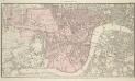
PLAN OF WESTMINSTER. No III
The area shaded red represents the extent of Westminster as defined in the Letters Patent of 3 August 1604. Basire, J.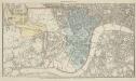
PLAN OF WESTMINSTER. No II
This map is highlighted to give a retrospective view of the extent of Westminster. Represented in blue is the territory of Westminster according to the Decretal of AD1222 , while the red outline shows the present boundary. The green and yellow outlines indicate manor boundaries. Basire, J.
PLAN OF WESTMINSTER. No 1 [A Plan of the City of Westminster, showing all the Parishes, as well as the Ancient Boundary of Westminster, in the year 951.]
An orange coloured area shows the extent of Westminster according to King Edgar's Charter of AD951. The contemporary boundary of Westminster is shown in red. Basire, J.
London NW.
1 : 15840 Stanford, Edward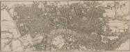
Map of London
This untitled map is a later edition one first published by Phillips in the 1802'Picture of London'. The map is divided into mile squares with letters along the border for reference, and shows the new London Docks. The proposed street layout across the fields in Shoreditch, between Mile End Road and Bethnal Green Road, is indicated by a double dotted line. Phillips, Richard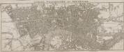
LONDON WESTMINSTER AND SOUTHWARK
The title of this small map runs along the top, with the imprint and scale bar below the plan. The map shows Waterloo Bridge, or Strand Bridge, with the proposed southern approach indicated by a dotted line. Designed by John Rennie, Waterloo Bridge was constructed by a commercial company hoping to profit from toll-paying traffic. The bridge cost 1m and was never profitable. The bridge was demolished and replaced controversially in 1936. Luffman, John
London SW.
1 : 15840 Stanford, Edward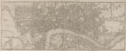
A PLAN of LONDON with the MODERN IMPROVEMENTS
This map is a later edition one first issued by Phillips at the beginning of the 19th Century, re-engraved by Neele with the addition of plans for the London Docks at Wapping. Daniel Alexander’s original design for this area comprised the 20-acre St. George’s Dock, to the west, and the seven-acre Shadwell Dock, to the east. Each would have its own basin, and be linked by a small Tobacco Dock. When opened in 1805the London Docks were the nearest to the city and for 21 years all shipments of tobacco, rice, wine and brandy (except those from the East and West Indies) had to unload there. Phillips, Richard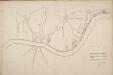
Thames and Metropolis Improvement plan
Martin, John
A PLAN of the ROADS Under the DIRECTION and CARE of this TRUST and divers Roads Adjacent.
1 : 16351 The title of this road map of Kensington and Chelsea appears in a panel above the plan, with the compass star at top right and scale bar at bottom left. The roads within the Kensington and Hyde Park Trust are indicated by a shadowed line; the king's private roads by a double line; the common roads by a double dotted line; and the footpaths by a single dotted line. Turnpikes and junctions are numbered for reference with distances given in a table down the left side of the plate. Roberts, R.