Maps of Westminster

Drawn plan of the Goring Estate] 3
This is a copy made by Crace in the 19th Century of the Goring Estate in 1675. This is the site on which Buckingham Palace was built.
Plan of a LEASEHOLD ESTATE Situate at Pimlico IN THE COUNTY OF MIDDLESEX belonging to ... 1825
1 : 2400 This is a plan of the leasehold of Earl Grosvenor,later Marquis of Westminster, in Belgrave Square. Earl Grosvenor was granted permission by Parliament to develop the ten acre site in 1826, and commisioned the young architect George Basevi, a pupil of John Soane's, to design the square. Grosvenor's name has been smudged from the title at top right.
Plan of Belgrave Square
1 : 1596 This drawn plan also shows adjoining properties in Knightsbridge. Earl Grosvenor was granted permission by Parliament to develop the ten acre site in 1826, and commisioned the young architect George Basevi, a pupil of Sir John Soane, to design the square. Chawner, Thomas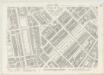
London VII.91 - OS London Town Plan
1 : 1056 Topographic maps Ordnance Survey Ordnance Survey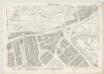
London VII.81 - OS London Town Plan
1 : 1056 Topographic maps Ordnance Survey Ordnance Survey
Drawn plan of the freehold ground belonging to Sir Charles Sheffield
This is Crace's own copy of an 18th Century survey of the freehold ground belonging to Sir Charles Sheffield, Duke of Buckingham. The drawing depicts the site where Buckingham Palace now stands. Explanatory note at lower left gives terms of lease of various parts of the freehold. Evans, Charles
Insurance Plan of London Western District Vol. A: sheet 2
1 : 480 This detailed 1901 plan of London is one of a series of forty-one sheets in an atlas originally produced to aid insurance companies in assessing fire risks. The building footprints, their use (commercial, residential, educational, etc.), the number of floors and the height of the building, as well as construction materials (and thus risk of burning) and special fire hazards (chemicals, kilns, ovens) were documented in order to estimate premiums. Names of individual businesses, property lines, and addresses were also often recorded. Together these maps provide a rich historical shapshot of the commercial activity and urban landscape of towns and cities at the time. The British Library holds a comprehensive collection of fire insurance plans produced by the London-based firm Charles E. Goad Ltd. dating back to 1885. These plans were made for most important towns and cities of the British Isles at the scales of 1:480 (1 inch to 40 feet), as well as many foreign towns at 1:600 (1 inch to 50 feet). Chas E Goad Limited Chas E Goad Limited
Insurance Plan of London West Vol. A: sheet 2
1 : 480 This detailed 1891 plan of London is one of a series of fourteen sheets in an atlas originally produced to aid insurance companies in assessing fire risks. The building footprints, their use (commercial, residential, educational, etc.), the number of floors and the height of the building, as well as construction materials (and thus risk of burning) and special fire hazards (chemicals, kilns, ovens) were documented in order to estimate premiums. Names of individual businesses, property lines, and addresses were also often recorded. Together these maps provide a rich historical shapshot of the commercial activity and urban landscape of towns and cities at the time. The British Library holds a comprehensive collection of fire insurance plans produced by the London-based firm Charles E. Goad Ltd. dating back to 1885. These plans were made for most important towns and cities of the British Isles at the scales of 1:480 (1 inch to 40 feet), as well as many foreign towns at 1:600 (1 inch to 50 feet). Chas E Goad Limited Chas E Goad Limited
Insurance Plan of London Western District Vol. A: sheet 13-2
1 : 480 This detailed 1901 plan of London is one of a series of forty-one sheets in an atlas originally produced to aid insurance companies in assessing fire risks. The building footprints, their use (commercial, residential, educational, etc.), the number of floors and the height of the building, as well as construction materials (and thus risk of burning) and special fire hazards (chemicals, kilns, ovens) were documented in order to estimate premiums. Names of individual businesses, property lines, and addresses were also often recorded. Together these maps provide a rich historical shapshot of the commercial activity and urban landscape of towns and cities at the time. The British Library holds a comprehensive collection of fire insurance plans produced by the London-based firm Charles E. Goad Ltd. dating back to 1885. These plans were made for most important towns and cities of the British Isles at the scales of 1:480 (1 inch to 40 feet), as well as many foreign towns at 1:600 (1 inch to 50 feet). Chas E Goad Limited Chas E Goad Limited
Insurance Plan of London West Vol. A: sheet 13-1
1 : 480 This detailed 1891 plan of London is one of a series of fourteen sheets in an atlas originally produced to aid insurance companies in assessing fire risks. The building footprints, their use (commercial, residential, educational, etc.), the number of floors and the height of the building, as well as construction materials (and thus risk of burning) and special fire hazards (chemicals, kilns, ovens) were documented in order to estimate premiums. Names of individual businesses, property lines, and addresses were also often recorded. Together these maps provide a rich historical shapshot of the commercial activity and urban landscape of towns and cities at the time. The British Library holds a comprehensive collection of fire insurance plans produced by the London-based firm Charles E. Goad Ltd. dating back to 1885. These plans were made for most important towns and cities of the British Isles at the scales of 1:480 (1 inch to 40 feet), as well as many foreign towns at 1:600 (1 inch to 50 feet). Chas E Goad Limited Chas E Goad Limited
Insurance Plan of London Western District Vol. A: sheet 13-1
1 : 480 This detailed 1901 plan of London is one of a series of forty-one sheets in an atlas originally produced to aid insurance companies in assessing fire risks. The building footprints, their use (commercial, residential, educational, etc.), the number of floors and the height of the building, as well as construction materials (and thus risk of burning) and special fire hazards (chemicals, kilns, ovens) were documented in order to estimate premiums. Names of individual businesses, property lines, and addresses were also often recorded. Together these maps provide a rich historical shapshot of the commercial activity and urban landscape of towns and cities at the time. The British Library holds a comprehensive collection of fire insurance plans produced by the London-based firm Charles E. Goad Ltd. dating back to 1885. These plans were made for most important towns and cities of the British Isles at the scales of 1:480 (1 inch to 40 feet), as well as many foreign towns at 1:600 (1 inch to 50 feet). Chas E Goad Limited Chas E Goad Limited
Knightsbridge showing Cannon Brewhouse
Knightsbridge isrepresented here in plan and elevation. The architectural details of thebuildings are faithfullyillustrated anda taste for order and symmetry is revealed by the garden plans,showing neat lawns andcobbled paths. Lamp posts are numbered, water pumps and drains are recorded by miniature representations.The Westbourne Brook features in the drawing. Fed by five streamswhich joined near Kilburn, it rose in West Hampstead and flowed under Knightsbridge and south to the Thames.The bridge that can be seen in the distance crossing the Westbourne was where, according to legend,two knights fought to their deaths. It is due to this legend that the village came to be called Knightsbridge. It was plagued by highway men and much celebrated for its taverns. The White Hart, shown here, is known to have existed as early as 1631. Salway, Joseph
Hyde Park Corner showing the Piccadilly Turnpike
This section of drawing shows the Piccadilly Turnpike at Hype Park Corner, the terminus of one of the ancient highways leading into London. A weighing engine is shown in red ink, indicating that tolls were increased depending on the weight of the vehicle and load. The meticulous nature of these drawings is revealed by the numbered lamp posts, each drawn with a shadow. Private gardens are shown in plan form, revealing the formal designs of lawns and cobblestone paths. St George's Hospital, located opposite the park, was founded in 1733 by a group of Governors from Westminster Hospital who chose Lanesborough House as the building to house their new hospital. Knightsbridge had a reputation for healthiness and they wanted their patients to benefit from the country air. Salway, Joseph
Insurance Plan of London Western District Vol. A: sheet 8-1
1 : 480 This detailed 1901 plan of London is one of a series of forty-one sheets in an atlas originally produced to aid insurance companies in assessing fire risks. The building footprints, their use (commercial, residential, educational, etc.), the number of floors and the height of the building, as well as construction materials (and thus risk of burning) and special fire hazards (chemicals, kilns, ovens) were documented in order to estimate premiums. Names of individual businesses, property lines, and addresses were also often recorded. Together these maps provide a rich historical shapshot of the commercial activity and urban landscape of towns and cities at the time. The British Library holds a comprehensive collection of fire insurance plans produced by the London-based firm Charles E. Goad Ltd. dating back to 1885. These plans were made for most important towns and cities of the British Isles at the scales of 1:480 (1 inch to 40 feet), as well as many foreign towns at 1:600 (1 inch to 50 feet). Chas E Goad Limited Chas E Goad Limited
Knightsbridge showing Knightsbridge Chapel
This sheet depicts a section of Knightsbridge showing the chapel in plan and elevation. The meticulous nature of Salway's drawings is revealed by the level of detail with which architectural features of houses, shops and taverns are represented in the elevation at the top of the sheet. Kennels, drains and grates are depicted in plan form in the lower part of the sheet. Lamp posts are numbered and drawn three dimensionally with a shadow. Salway, Joseph
Insurance Plan of London West Vol. A: sheet 13-3
1 : 480 This detailed 1891 plan of London is one of a series of fourteen sheets in an atlas originally produced to aid insurance companies in assessing fire risks. The building footprints, their use (commercial, residential, educational, etc.), the number of floors and the height of the building, as well as construction materials (and thus risk of burning) and special fire hazards (chemicals, kilns, ovens) were documented in order to estimate premiums. Names of individual businesses, property lines, and addresses were also often recorded. Together these maps provide a rich historical shapshot of the commercial activity and urban landscape of towns and cities at the time. The British Library holds a comprehensive collection of fire insurance plans produced by the London-based firm Charles E. Goad Ltd. dating back to 1885. These plans were made for most important towns and cities of the British Isles at the scales of 1:480 (1 inch to 40 feet), as well as many foreign towns at 1:600 (1 inch to 50 feet). Chas E Goad Limited Chas E Goad Limited
Insurance Plan of London Western District Vol. A: sheet 3
1 : 480 This detailed 1901 plan of London is one of a series of forty-one sheets in an atlas originally produced to aid insurance companies in assessing fire risks. The building footprints, their use (commercial, residential, educational, etc.), the number of floors and the height of the building, as well as construction materials (and thus risk of burning) and special fire hazards (chemicals, kilns, ovens) were documented in order to estimate premiums. Names of individual businesses, property lines, and addresses were also often recorded. Together these maps provide a rich historical shapshot of the commercial activity and urban landscape of towns and cities at the time. The British Library holds a comprehensive collection of fire insurance plans produced by the London-based firm Charles E. Goad Ltd. dating back to 1885. These plans were made for most important towns and cities of the British Isles at the scales of 1:480 (1 inch to 40 feet), as well as many foreign towns at 1:600 (1 inch to 50 feet). Chas E Goad Limited Chas E Goad Limited
Insurance Plan of London West Vol. A: sheet 3
1 : 480 This detailed 1891 plan of London is one of a series of fourteen sheets in an atlas originally produced to aid insurance companies in assessing fire risks. The building footprints, their use (commercial, residential, educational, etc.), the number of floors and the height of the building, as well as construction materials (and thus risk of burning) and special fire hazards (chemicals, kilns, ovens) were documented in order to estimate premiums. Names of individual businesses, property lines, and addresses were also often recorded. Together these maps provide a rich historical shapshot of the commercial activity and urban landscape of towns and cities at the time. The British Library holds a comprehensive collection of fire insurance plans produced by the London-based firm Charles E. Goad Ltd. dating back to 1885. These plans were made for most important towns and cities of the British Isles at the scales of 1:480 (1 inch to 40 feet), as well as many foreign towns at 1:600 (1 inch to 50 feet). Chas E Goad Limited Chas E Goad Limited
Insurance Plan of London West Vol. A: sheet 13-2
1 : 480 This detailed 1891 plan of London is one of a series of fourteen sheets in an atlas originally produced to aid insurance companies in assessing fire risks. The building footprints, their use (commercial, residential, educational, etc.), the number of floors and the height of the building, as well as construction materials (and thus risk of burning) and special fire hazards (chemicals, kilns, ovens) were documented in order to estimate premiums. Names of individual businesses, property lines, and addresses were also often recorded. Together these maps provide a rich historical shapshot of the commercial activity and urban landscape of towns and cities at the time. The British Library holds a comprehensive collection of fire insurance plans produced by the London-based firm Charles E. Goad Ltd. dating back to 1885. These plans were made for most important towns and cities of the British Isles at the scales of 1:480 (1 inch to 40 feet), as well as many foreign towns at 1:600 (1 inch to 50 feet). Chas E Goad Limited Chas E Goad Limited
Insurance Plan of London West Vol. A: sheet 8-1
1 : 480 This detailed 1891 plan of London is one of a series of fourteen sheets in an atlas originally produced to aid insurance companies in assessing fire risks. The building footprints, their use (commercial, residential, educational, etc.), the number of floors and the height of the building, as well as construction materials (and thus risk of burning) and special fire hazards (chemicals, kilns, ovens) were documented in order to estimate premiums. Names of individual businesses, property lines, and addresses were also often recorded. Together these maps provide a rich historical shapshot of the commercial activity and urban landscape of towns and cities at the time. The British Library holds a comprehensive collection of fire insurance plans produced by the London-based firm Charles E. Goad Ltd. dating back to 1885. These plans were made for most important towns and cities of the British Isles at the scales of 1:480 (1 inch to 40 feet), as well as many foreign towns at 1:600 (1 inch to 50 feet). Chas E Goad Limited Chas E Goad Limited
Insurance Plan of London Western District Vol. A: sheet 13-3
1 : 480 This detailed 1901 plan of London is one of a series of forty-one sheets in an atlas originally produced to aid insurance companies in assessing fire risks. The building footprints, their use (commercial, residential, educational, etc.), the number of floors and the height of the building, as well as construction materials (and thus risk of burning) and special fire hazards (chemicals, kilns, ovens) were documented in order to estimate premiums. Names of individual businesses, property lines, and addresses were also often recorded. Together these maps provide a rich historical shapshot of the commercial activity and urban landscape of towns and cities at the time. The British Library holds a comprehensive collection of fire insurance plans produced by the London-based firm Charles E. Goad Ltd. dating back to 1885. These plans were made for most important towns and cities of the British Isles at the scales of 1:480 (1 inch to 40 feet), as well as many foreign towns at 1:600 (1 inch to 50 feet). Chas E Goad Limited Chas E Goad Limited
Drawn Plan of the Houses, Stables and Gardens in Hamilton Place
1 : 480 This plan shows the renovations on the Crown Estate in Hamilton Place, Piccadilly. The plan features a scale bar at the bottom centre. The ground plans of the stables in Hamilton Mews and various basement accommodations are indicated in pale blue. Chawner, Thomas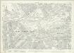
London (1915- Numbered sheets) V.13 (includes: City Of Westminster) - 25 Inch Map
1 : 2500 Topographic maps Ordnance Survey Ordnance Survey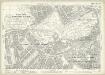
London (Edition of 1894-96) LXXV (includes: City Of Westminster) - 25 Inch Map
1 : 2500 Topographic maps Ordnance Survey Ordnance Survey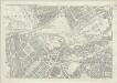
London (First Editions c1850s) XLIII (includes: City Of Westminster) - 25 Inch Map
1 : 2500 Topographic maps Ordnance Survey Ordnance Survey
Drawn plan of the Goring Estate] 3
This is a copy by Crace of a plam of the Goring Estate as it was in 1640. The drawing shows the site in Mulberry Garden Fields where Buckingham Palace was built. Crace, Frederick
Insurance Plan of London: General Key Plan
1 : 4800 This "key plan" indicates coverage of the Goad 1889 series of fire insurance maps of London that were originally produced to aid insurance companies in assessing fire risks. The building footprints, their use (commercial, residential, educational, etc.), the number of floors and the height of the building, as well as construction materials (and thus risk of burning) and special fire hazards (chemicals, kilns, ovens) were documented in order to estimate premiums. Names of individual businesses, property lines, and addresses were also often recorded. Together these maps provide a rich historical shapshot of the commercial activity and urban landscape of towns and cities at the time. The British Library holds a comprehensive collection of fire insurance plans produced by the London-based firm Charles E. Goad Ltd. dating back to 1885. These plans were made for most important towns and cities of the British Isles at the scales of 1:480 (1 inch to 40 feet), as well as many foreign towns at 1:600 (1 inch to 50 feet). Chas E Goad Limited Chas E Goad Limited
ST. GEORGE'S PARISH, HANOVER SQUARE.
1 : 8448 This plan of the Parish of St George is surrounded by views of St George's church, Knightsbridge chapel, Conduit Street chapel, Chelsea chapel, Audley Street chapel and Berkeley chapel, the whole set within a decorative border. The title and imprint appear at the foot of the plate. The Parish of St George was created in 1725 and covered an area previously in the Parish of St. Martin-in-the-Fields that stretched from Regent Street (then called Swallow Street) to the Serpentine, and from Oxford Street to Mayfair, Belgravia and Pimlico. Bickham, J.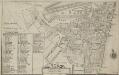
Plan of the Parish of St. Margaret, Westminster From Lea & Morden's Map
1 : 6336 The Abbey, Manchester House and the parish church are shown in elevation. The Decoy in St James' Park is shown. Robert Lea
![Drawn plan of the Goring Estate] 3](https://images-2.georeferencer.com/images/iiif/756056346485/full/,300/0/native.jpg)

