Maps of Westminster
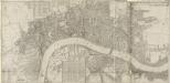
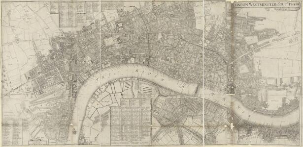
LONDON, WESTMINSTER & SOUTHWARK
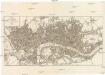
This map of London was printed in six sections. The title appears in ribbon at top right, with a compass in the river at lower left, facing a key to company halls in a table at top left. City wards and parishes are shown in a table at bottom centre, with the streets of Westminster in a table at bottom left. Morden, Robert & Lea, Philip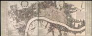
A New and Exact Plan of Ye City of London and suburbs thereof, 1731 93
This is the third edition of Overton's map of London and the suburbs first issued in 1720. The map features title in cartouche at top left, lists of Hackney coaches and watermen's rates at bottom left and centre, City arms at bottom right and compass in river. The area within the boundaries of the City of London is stippled, with ward boundaries highlighted in colour. The map is divided in squares with letters along the margins for reference. Overton, Henry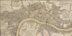
A Pocket MAP of LONDON, WESTMINSTER and SOUTHWARK With the New Buildings to ye Year 1760. Not Extant in any other Map.
The title of this map appears in ornamental cartouche at top left, with fares of hackney coaches in tables at top- and middle-right. Fares of water ferries feature at bottom centre. The built-up area is stippled in the City of London itself, and hatched elsewhere, with the city boundaries outlined in colours. The map is a later edition of the map first issued by George Foster in 1739, updated to include the approaches to Westminster Bridge and the intended new bridge at Blackfriars. Sayer, Robert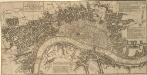
The CITY GUIDE or A Pocket MAP of LONDON, WESTMINSTER And SOUTHWARK With ye New Buildings to ye Year 1742
The title of this pocket map appears in a panel at top left, with the publisher's imprint below the plan and fares of hackney coaches and water ferries in tables at top right and bottom centre. The map shows the new bridge at Westminster and represents the built-up within the city by stippling. An engraver by trade, Thomas Bowles acquired Morden & Lea's stock at the beginning of the 18th Century and started a successful publishing house whose output was almost entirely derivative. Thomas Bowles's business was separate from that of his brother John, but the two often worked together. Bowles, John & Thomas
The LONDON GUIDE, or A POCKET PLAN of the CITIES OF LONDON & WESTMINSTER and BOROUGH of SOUTHWARK with the BEW BUILDINGS, &C to the present year 1767.
The title of this map of Georgian London features along the top. Rates of hackney coaches are noted at top- and middle-right, with rates of water ferries at bottom centre. A member of the Joiners Livery Company, Carrington Bowles continued the family printing and publishing business started by his father, John, and uncle, Thomas. Bowles, Carington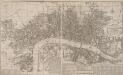
A New and Exact PLAN of the CITIES OF LONDON & WESTMINSTER and the Borough of SOUTHWARK. With all y.e Additional New Buildings to y.e Present Year 1724
The title of this map of London appears in cartouche at middle right, with compass rose at top right, and a key to buildings at bottom right. A historical note appears at bottom centre along with a scale bar, the fares of hackney coaches and water ferries, and illustrations of oars and sculls. This map is divided into squares with numbers along borders for reference. Smith, John
A Pocket MAP of LONDON, WESTMINSTER And SOUTHWARK With ye New Buildings to ye Year 1745
This is a later edition of a map first issued by Lyne in 1741. The title and scale bar appear at top left, with fares of hackney coaches in tables at top and middle right, fares of water ferries at bottom centre, and an advertisement for a set of the arms of the great twelve livery companies at bottom left. The map shows St. Paul's Cathedral, the Tower of London and Westminster Bridge three-dimensionally, with the built-up area stippled within the City and hatched elsewhere and with the boundaries of the City outlined in colour. Lyne, S.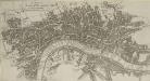
A MAP of LONDON, WESTMINSTER and SOUTHWARK. With ye New Buildings to ye Year 1733
This pocket map of London was published as the frontispiece to Volume I of "A Survey of the cities of London and Westminster, Borough of Southwark", by Robert Seymour. No new survey of the London area had been made between William Morgan's in 1682 and John Rocque's of 1746. The marked similarity of this map to the William Roades' 1731pocket map is testimony to this. The title of this drawing appears in a square tablet at top left, with prominent buildings shown pictorially. Robert Seymou (pseudonym of John Mottley)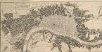
A MAP of LONDON, WESTMINSTER And SOUTHWARK With ye New Buildings to ye Year 1764
This pocket map of London was published in 'A New History of London' by the Reverend George Reeves. Its title appears in a square table near top left, with built-up areas in the city stippled while other built-up areas are hatched. St. Paul's Cathedral and other prominent buildings are represented pictorially. The map is a derivative of a 1740 map showing the housing development north of Cavendish Square, which was never built.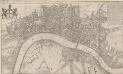
A New Mapp of the CITTY OF LONDON much Inlarged since the great Fire in 1666
This title of this map of Stuart London appears along the top, with the City arms depicted at top left, and a reference panel at top right. A scale bar with dividers features at bottom left, with the key to individual churches in Southwark in a banner at bottom right. Like many other contemporary plans of London, this one is derivative of Hollar's posthumously published map of1685. Overton, John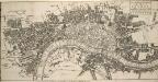
The ICHNOGRAPHY of the Cities of LONDON and WESTMINSTER and the Borough of SOUTHWARK 115x
This small map was published in 'The Natural History of England' by the scientist and instrument-maker Benjamin Martin. It comprised part of the complete 'General Magazine of Arts and Science' issued between 1756 and 1761. The map's title features in a square table at top right, and represents the built-up area within the city boundaries with stippling, and other built-up areas with crosshatching. "Ichnography" means ground-plan. Owen, William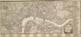
A PLAN of the CITIES of LONDON AND WESTMINSTER and BOROUGH of SOUTHWARK 1771
The reference key of this map extends along the right margin and bottom of the map, with the title is in a cartouche. This map shows proposed lines of approach towards Blackfriars Bridge, later abandoned. Andrews, J.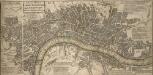
A Pocket MAP of LONDON, WESTMINSTER and SOUTHWARK With ye New Buildings to ye Year 1759
This pocket map of London is reminiscent of Henry Overton's map of 1731.The title and scale bar appear at top left, fares of hackney coaches feature at top and middle right, and fares of water ferries at bottom centre. A note on distances, churches and public buildings is included at bottom right with the city boundaries outlined in colour. Robert Whity, who issued this map in 1759, added a sheet to include the development north of Oxford Street in the estate of Henry Cavendish, Duke of Newcastle, where Cavendish Square was at the centre of a new residential district being built by Edward Harley, the duke’s son-in-law. Whity, Robert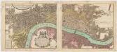
Urbium Londini et West-Monasterii nec non suburbii Southwark accurata ichnographia : in qua viae publicae omnes et singulae, plateae majores et minores, vici, angiporti, porticulae etc. una cum accessionibus aedificiorum, quibus urbs usque ad a. 1736, novissime locupletata est, reprasentantur : ad norman prototypi Londinensis edita curris Hommannianorum Heredum C.P.S.C.M
1 : 5280 Homann Erben (Firm) Homaennischen Erben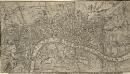
A Correct PLAN of the CITIES of LONDON & WESTMINSTER & BOROUGH of SOUTHWARK, including the BILLS of MORTALITY, with the ADDITIONAL BUILDINGS 118x
This map of London was published as a supplement to Vol. 30 of the 'London Magazine' in 1761. Attributed to John Rocque, the map’s title features in panel below the plan with the publisher’s imprint along the top. The Bills of Mortality referred to in the title were the areas in Greater London that reported death notices directly to the London government. Rocque, John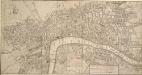
A New and Correct PLAN of LONDON, WESTMINSTER and SOUTHWARK, with several Additional Improvements, not in any former Survey
The title of this map appears in a square table at bottom right with the publisher’s imprint and scale bar below the plan. The writer, poet and dramatist Robert Dodsley and his brother, the print- and book-seller James, were business partners and issued this map from their shop in Pall Mall in 1761. Dodsley, Robert & James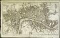
Plan nouveau et correct des villes et fauxbourgs de Londres et Westminster et du bourg de Southwark
1 Plan : Kupferdruck ; 28 x 48 cm Le Rouge Georges Louis le Rouge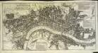
A pocket map of London, Westminster and Southwark
1 Plan : Kupferdruck ; 26 x 51 cm Hoole; Seale printed and sold by H. Overton and J. Hoole at the White Horse without Newgate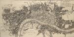
The ICHNOGRAPHY of the Cities of LONDON and WESTMINSTER and the Borough of SOUTHWARK 115
"Ichnography" means ground-plan. This small map was published in 'The Natural History of England' by the scientist and instrument-maker Benjamin Martin. This was part of the complete work 'General Magazine of Arts and Science' issued between 1756 and 1761. The map's title appears in a square table at top right. Built-up areas are stippled within the boundaries of the City of London, and crosshatched elsewhere. Owen, William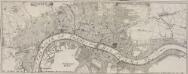
LONDEN, WESTMUNSTER U: SOUDWARK
The title of this German map of London, Westminster and Southwark, appears between two ribbons at the top. A compass rose appears in the river, with prominent buildings shown pictorially instead of in plan and numbered for reference. Stridbeck, Johannes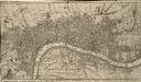
A Correct PLAN of the CITIES of LONDON & WESTMINSTER & BOROUGH of SOUTHWARK, including the BILLS of MORTALITY, with the ADDITIONAL BUILDINGS 118
This map of London was published as supplement to Volume 30 of the 'London Magazine' in 1761. Attributed to John Rocque, the map's title features in a panel below the plan, with the publisher’s imprint along the top. [Rocque, John]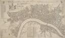
A NEW Mapp of the CITY of LONDON &c. With the Many additional Buildings and New Streets Anno 1720 In a Playne Method for Easy finding any street at first View
This is a later edition of a map first published in 1716. The title appears along the top, with a key to churches at top left, alongside coats of arms representing the City and the twelve Great Livery Companies. The key to individual city wards appears at top right. At bottom left are a compass rose, scale bar and the key to public buildings. Rates of hackney coaches and water ferries appear in a table at bottom centre. The map is similar to Overton’s map of 1706, showing St. Paul's and other prominent buildings pictorially. Taylor, Thomas
London, Westminster and Southwark
1 : 10138 This untitled map of Stuart London features royal arms at top left, city arms at top right, with a scale bar and dividers shown beneath a female figure with a globe at lower left. A key to Southwark's churches is provided at lower right. This map is derivative of Wenceslaus Hollar posthumously published plan of 1685 and features vignettes of prominent buildings along the top, together with portraits of King William and Queen Mary. At the foot of the plate, views of the seven city gates and the Tower of London accompany equestrian statues of Charles I and Charles II.
A New and Exact Plan of Ye City of London and Westminster, the Borough of Southwark, 1735
This map of London is probably based on an earlier map by William Morgan dating 1681-82. It features title in cartouche near bottom centre, rates of coaches and ferries to the right of the title and explanatory note to the left. The map is divided in squares with margins lettered for reference and key in columns at the foot of the plate. Westminster Bridge and other prominent buildings represented pictorially. Jeffreys, Thomas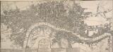
The LONDON GUIDE, or A POCKET PLAN of the CITIES OF LONDON & WESTMINSTER and BOROUGH of SOUTHWARK with the BEW BUILDINGS, &C to the present year
This map of Georgian London was published in John Entick's 1766'A New and Accurate History and Survey of London, Westminster and Southwark.' The title of the map appears in a panel below the plan along with the rates of hackney coaches and water ferries. It extends eastward to include Limehouse, then one of the main centres for shipbuilding in the capital. Bowles, Carington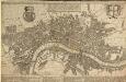
A POCKET MAP OF LONDON, WESTMINSTER AND SOUTHWARK With ye New Buildings to ye Year 1739
The map's title appears in English and Dutch in a panel along the top. A descriptive note features below the title, with royal arms at top left, city arms at top right and fares of hackney coaches and water ferries in a panel below the plan. The map shows the new bridge at Westminster and represents prominent buildings and landmark three-dimensionally. De Leth, Hendrick
Bowles's reduced new pocket plan of the cities of London
1 : 15700 Londýn (Anglie) Bowles, Carington Carington Bowles
An IMPROVED PLAN of the CITIES of LONDON and WESTMINSTER and BOROUGH of SOUTHWARK, including the NEW BUILDINGS, ROADS &C. to the Present Year 1765.
The title of this pocket map appears along the top, with built-up areas represented by stippling in the City of London, and crosshatching elsewhere. A table of reference appears in a panel below the plan. The map, a later edition of Kitching and Parker's 1765 plan, shows the new bridge and the approaches at Blackfriars. Designed by Robert Mylne, this third bridge spanning the Thames was built between 1760 and 69. The nine semi-elliptical Portland stone arches were replaced from 1860 to 69 by the present structure of five wrought-iron arches each faced with cast iron, and a granite pier designed by Cubitt and Carr. Kitching, Thomas and Parker, Henry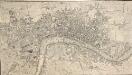
A NEW and Correct PLAN OF THE CITIES AND SUBURBS OF LONDON & WESTMINSTER & BOROUGH OF SOUTHWARK with the COUNTRY adjacent, the NEW BUILDINGS, ROADS &c. to the Year 1766
The title of this map runs along the top of the plan, which shows the new bridge at Blackfriars as "Pitt's Bridge". Designed by Robert Mylne, this third bridge spanning the Thames was built between 1760 and 69. The nine semi-elliptical Portland stone arches were replaced in a hundred years later by the present structure of five wrought-iron arches faced with cast-iron, and a granite pier designed by Cubitt and Carr. Gibson, John
Plan von London und Westminster mit der Borough von Southwark
Londýn (Anglie)