Maps of Aberdeenshire

Ordnance Survey of Great Britain, Scotland
Ordnance Survey
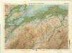
Scotiæ provinciæ intra flumen Taum, et Murra fyrth sitæ
1 Karte : Kupferdruck ; 42 x 51 cm Valck; Schenk Gerard Valck et Pieter Schenk
Scotiae Provinciae intra Flumen Taum, et Murrafyrth sitae, utpote Moravia, Badenocha, Atholia, Aberdonia, Baneia et Mernis. [Karte], in: Novus atlas absolutissimus, Bd. 8, S. 163.
1 Karte aus Atlas Janssonius Offizin
DVO VICECOMITATVS | ABERDONIA & BANFIA, | Una cum Regionibus & terrarum tractibus | sub iis comprehensis. [=] A Description of the two Shyres | ABERDENE and BANF, | With such Countreys and Provinces as ar | comprehended under them.
Auctore Roberto Gordonio à Straloch. [Amsterdam : Joan Blaeu]
Scotiæ provinciæ mediterraneæ inter Taum flumen | et Vararis æstuarium: Sunt autem | BRAID-ALLABAN, ATHOLIA, MARRIA SVPERIOR. | BADENOCHA, STRATH-SPEA, LOCHABRIA, | cum Chersoneso qui ei ad occasum prætenditur; | cum singulis earundem partibus. [=] a Description of the inland provinces of SCOTLAND lying | betueen Tay river and Murra fyrth, conteyning | BRAID-ALLABAN, ATHOL, BRAE OF MAR, BADENOCH, STRATH-SPEY, LOCHABYR, | wt al ye lands which ley west from LOCHABYR wt all thair | parts conteyned under them.
Opera Ro. Gordonii a Straloch. [Amsterdam : Joan Blaeu]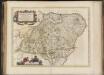
Duo Vicecomitatus Aberdonia & Banfia, una cum Regionibus & terrarum tractibus sub iis comprehensis / Auctore Roberto Gordonio à Straloch. Description of the two Shyres Aberdene and Banf,
Gordon, Robert, 1580-1661 Blaeu, Joan, 1596-1673
Dvo vicecomitatvs Aberdonia [et] Banfia
1 Karte : Kupferdruck ; 41 x 54 cm Blaeu; Gordon Joan Blaeu
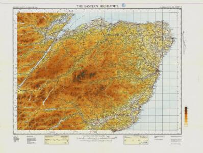
Topographical and military map of the counties of Aberdeen, Banff and Kincardine.
Robertson, James, fl. 1810-1829
Topographical and military map of the counties of Aberdeen, Banff and Kincardine.
Robertson, James, fl. 1810-1829
Topographical and military map of the counties of Aberdeen, Banff and Kincardine.
Robertson, James, fl. 1810-1829
Topographical and military map of the counties of Aberdeen, Banff and Kincardine.
Robertson, James, fl. 1810-1829
Topographical and military map of the counties of Aberdeen, Banff and Kincardine.
Robertson, James, fl. 1810-1829
Topographical and military map of the counties of Aberdeen, Banff and Kincardine.
Robertson, James, fl. 1810-1829
Composite: Inverness Shire.
1 : 128000 Johnson, William, fl. 1806-1840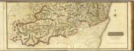
Composite: South Aberdeen, Banff S.
1 : 95000 Thomson, John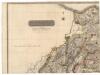
Northern Part of Aberdeen & Banff Shires.
Thomson, John, 1777- ca. 1840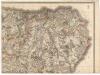
Northern Part of Aberdeen & Banff Shires.
Thomson, John, 1777- ca. 1840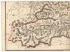
Southern Part of Aberdeen & Banff Shires.
Thomson, John, 1777- ca. 1840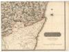
Southern Part of Aberdeen & Banff Shires.
Thomson, John, 1777- ca. 1840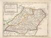
The Shires of Bamf [i.e. Banff] and Aberdeen / by H. Moll.
Moll, Herman, d. 1732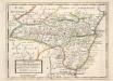
The Shire of Kincairden or Mears with the South Part of Aberdeen Shire &c. / H. Moll.
Moll, Herman, d. 1732
Composite: Aberdeen, Banff S.
1 : 95000 Thomson, John
Southern Part of Inverness Shire.
Thomson, John, 1777- ca. 1840 Johnson, William, fl. 1806-1840
Northern Part of Inverness Shire.
Thomson, John, 1777- ca. 1840 Johnson, William, fl. 1806-1840
Northern Part of Inverness Shire.
Thomson, John, 1777- ca. 1840 Johnson, William, fl. 1806-1840
Southern Part of Inverness Shire.
Thomson, John, 1777- ca. 1840 Johnson, William, fl. 1806-1840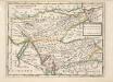
The East Part of the Shire of Inverness with Badenoch &c. / by H. Moll.
Moll, Herman, d. 1732
Atholl & Badenoch, Sheet 16 - Bartholomew's "Half Inch to the Mile Maps" of Scotland
1 : 126720 Topographic maps John Bartholomew & Son, Ltd John Bartholomew & Son, Ltd
Braemar and Blair Atholl, Sheet 16 - Bartholomew's "Half Inch to the Mile Maps" of Scotland
1 : 126720 Topographic maps Bartholomew, John George John Bartholomew & Co
Moray and Black Isle, Sheet 21 - Bartholomew's "Half Inch to the Mile Maps" of Scotland
1 : 126720 Topographic maps John Bartholomew & Son, Ltd John Bartholomew & Son, Ltd