Maps of Powys

South Wales and the border in the 14th century
Rees, William Ordnance Survey
A New and accurate map of Radnor Shire
1 : 237600
Sheets 31-32. (Cary's England, Wales, and Scotland).
1 : 360000 Cary, John, ca. 1754-1835
Shropshire, Sheet 17 - Bartholomew's "Half Inch to the Mile Maps" of England & Wales
1 : 126720 Topographic maps Bartholomew, John George John Bartholomew & Co
Radnoriensis Comitatus vulgo the counties of Radnor
1 : 180000 Amstelodami : apud Joannem Janssonium

RADNORIA | COMITATVS | RADNOR SHIRE.
[Amsterdam : Joan Blaeu]
Radnoria Comitatus Radnor Shire. [Karte], in: Theatrum orbis terrarum, sive, Atlas novus, Bd. 4, S. 398.
1 Karte aus Atlas Blaeu, Joan Blaeu, Willem Janszoon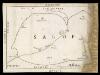
Map of Shropshire f. 75*
This is a manuscript map of Shropshire. It forms part of an atlat which belonged to Lord Burghley, Secretary of State to Elizabeth I, who used it to illustrate domestic matters. It shows only the principal towns, distinguishing between those with a castle and those without by means of a symbol of two connected towers with crenellations. The River Severn, marked Sabrina F, is charted. Lord Burghley has added a name adjacent to a place where the river is bridged. Lord Burghley was concerned with communication routes as revealed by his annotation. The draughtsman has indicated relief by hill symbols in two places. The map features a scale bar, but this is partly obscured by damage to the map.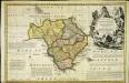
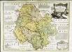
An accurate map of Radnor Shire
1 Karte : Kupferdruck ; 33 x 51 cm Kitchin; Tinney John Tinney
Radnoria comitatvs
1 Karte : Kupferdruck ; 37 x 48 cm Blaeu Joan Blaeu
Radnoria Comitatus Radnor Shire. [Karte], in: Theatrum orbis terrarum, sive, Atlas novus, Bd. 4, S. 398.
1 Karte aus Atlas Blaeu, Joan Blaeu, Willem Janszoon
Radnoria Comitatus Radnor Shire. [Karte], in: Le théâtre du monde, ou, Nouvel atlas contenant les chartes et descriptions de tous les païs de la terre, Bd. 4, S. 344.
1 Karte aus Atlas Blaeu, Willem Janszoon und Blaeu, Joan Blaeu, Willem Janszoon
Radnoriensis Comitatus Vulgo The Countie of Radnor. [Karte], in: Novus atlas absolutissimus, Bd. 7, S. 381.
1 Karte aus Atlas Janssonius Offizin
Montgomery and Llandrindod Wells - OS One-Inch Map
1 : 63360 Topographic maps Ordnance Survey Ordnance Survey
Ludlow - OS One-Inch Map
1 : 63360 Topographic maps Ordnance Survey Ordnance Survey
An accurate map of Shrop Shire
1 Karte : Kupferdruck ; 51 x 68 cm Bowen; Hinton sold by J. Hinton at the Kings Arms in St. Pauls Church Yard
Comitatvs Salopiensis; anglice Shrop Shire
1 Karte : Kupferdruck ; 37 x 48 cm Blaeu Joan Blaeu
Herefordia Comitatus. Hereford-Shire. [Karte], in: Theatrum orbis terrarum, sive, Atlas novus, Bd. 4, S. 393.
1 Karte aus Atlas Blaeu, Joan Blaeu, Willem Janszoon
HEREFORDIA | COMITATVS. | HEREFORD-SHIRE.
[Amsterdam : Joan Blaeu]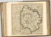
An accurate map of Hereford Shire
1 Karte : Kupferdruck ; 51 x 69 cm Bowen; Tinney sold by I. Tinney at the Golden Lion in Fleet street
Herefordia comitatvs
1 Karte : Kupferdruck ; 39 x 48 cm Blaeu Joan Blaeu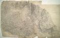
Bishop's Castle
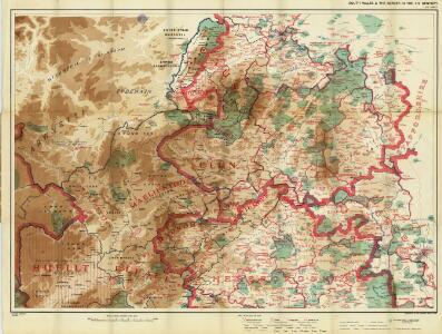
1 : 31680 The River Clun Valley dominates the right-hand section of this plan of Shropshire. To the left is Clun Forest, famous for the sheep of the same name. The plan shows a section of the Offa's Dike running from top left towards bottom right. Extending 176 miles along the English border from the northern Welsh coast south to Chepstow,this great earth bank is eight miles longer than Hadrian's Wall. Unlike Hadrian's Wall, it was never garrisoned. Budgen, Thomas
Actual Survey of the County of Salop
Rocque, John
Actual survey of the county of Salop, 3
1 Blatt : 71 x 53 cm John Rocque
Actual survey of the county of Salop, 4
1 Blatt : 71 x 53 cm John Rocque
Presteigne
1 : 31680 The Roman road, south to Hereford and beyond, runs across the Arrow Valley and Shobdon Marshes from top to bottom of this plan., At lower right, the River Arrow joins the River Lugg south of Leominster., The surrounding countryside appears intensively farmed., Throughout this region of Herefordshire,,based on rich red clay, farmland,dominates,in a,landscape of,well-hedged fields scattered,with small woods and threaded by,streams and brooks. Budgen, Thomas
Newtown
1 : 31680 The River Severn Valley,features,runs,from left to right on this plan of part of mid- Wales. With its source high on the Cumbrian Mountains, the river flows through,a narrow rocky channel in its upper course, becoming wider and deeper in its middle course and its valley flatter. Budgen, Thomas