Maps of Piedmont
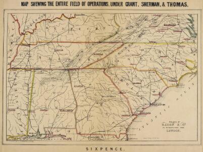
Map, shewing the Entire Field of Operations under Grant, Sherman & Thomas
Map, shewing the Entire Field of Operations under Grant, Sherman & Thomas. Published in London by Bacon & Co., this image of a Map Shewing the Entire Field of Operations, Under Grant, Sherman & Thomas details the Deep South Confederate States, principally of Tennessee, North Carolina, South Carolina, Georgia and Alabama, as well Virginia and the Union state of Kentucky. These areas witnessed the Union Army push in the last year and a half of the war, under the leadership of General Ulysses S. Grant. General George H. Thomas predominately fought in the western theatre of the conflict, while General William T. Sherman was responsible for the Army’s ultimately devastating march through the Southern states in 1864 and 1865. His marches through Georgia and the Carolinas, which crippled the home–front, remain a vital part of Civil War military history and Southern memory of the conflict. Bacon & Co.
Military map, W.T. Sherman.
1 : 2200000 United States. War Department
Military map showing the marches of the United States Forces 1863-1865.
1 : 1267200 United States. Army. Military Division of the Mississippi
A map of Virginia, North and South Carolina, Georgia, Maryland with part of New Jersey &c.
from Parts Printed for R. (Richard) Baldwin in Pater Noster Row: [London] -- Bookseller,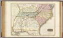
United States of America, southern part.
1 : 2200000 Pinkerton, John, 1758-1826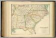
United States ... South Eastern States.
1 : 2851200 Fullarton, A. & Co.
The Field of Battle.
The Field of Battle and Prominent US Generals. The Field of Battle and Prominent Union Generals is one of the most picturesque maps in the collection, detailing the main theatres of conflict in the Confederacy, with each state broken up by counties, and surrounded by virtually all of the main Union Army generals that would have been well known to viewers in 1864 when this map was published in New York by Ensign & Bridgman. The generals are mostly all arranged close to the areas where they were conducting operations at the time of the map’s production, for example Generals Grant and Sherman are close to Georgia and South Carolina. Union Navy generals are also pictured, such as General David Farragut who can be seen close to the Georgia coastline. Ensign & Bridgman
Carte des Etats-unis : provinces méridionales.
from Parts
Campaigns in which the Army Of The Cumberland Took part during the War of the Rebellion.
1 : 1267200 Ruger, Edward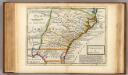
Carolina.
1 : 5500000 Moll, Herman, d. 1732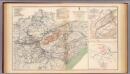
Army of the Cumberland campaigns.
1 : 2200000 United States. War Department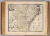
N. & S. Carolina, Georgia &c.
1 : 2900000 Bowen, Emanuel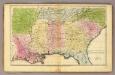
Southern States.
1 : 3600000 Huntington, Francis Junius, 1802-1878
Frank Leslie's war maps
Leslie, Frank
Army of the Cumberland.
1 : 7800000 National Tribune Co.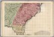
A Map of the British Empire in America. (Sheet 10).
1 : 2000000 Popple, Henry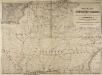
Railway Map of the Southern States, showing the Railway Lines, their Stations and intermediate distances between Louisville and the Gulf of Mexico and Southern Atlantic Coast, etc. Scale of miles, 20 to one inch.
Railway Map of the Southern States, showing the Railway Lines, their Stations and intermediate distances between Louisville and the Gulf of Mexico and Southern Atlantic Coast, etc.
Virginiae partis australis, et Floridae partis orientalis, interjacentiumq[ue] regionum, nova descriptio.
from John H. Levine Collection Meurs, Jacob van; Montanus, Arnoldus,
Virginiae partis australis, et Floridae partis orientalis, interjacentiumq[ue] regionum nova descriptio.
from Parts J. and C. Blaeu: [Amsterdam]; Blaeu, Joan; Blaeu, Willem Janszoon,
Virginiae partis australis et Floridae partis orientalis interjacentimq[ue] regionum, nova descriptio.
from Charts and maps Ioannem Ianssonium?: [Amstelodami?]; Jansson, Jan,
Virginiae partis australis, et Floridae partis orientalis, interjacentiumq[ue] regionum nova descriptio.
from Parts J. and C. Blaeu: [Amsterdam]; Blaeu, Joan; Blaeu, Willem Janszoon,
Virginiae partis australis, et Floridae partis orientalis, interjacentiumq[ue] regionum nova descriptio.
from John H. Levine Collection J. and C. Blaeu: [Amsterdam]; Blaeu, Joan; Blaeu, Willem Janszoon,
Virginiae partis australis, et Floridae partis orientalis, interjacentiumq[ue] regionum nova descriptio.
from Charts and maps J. and C. Blaeu: [Amsterdam]; Blaeu, Joan; Blaeu, Willem Janszoon,
Virginiae partis australis, et Floridae partis orientalis, interjacentiumq[ue] regionum nova descriptio.
from Parts J. and C. Blaeu: [Amsterdam]; Blaeu, Joan; Blaeu, Willem Janszoon,
Carte des Provines Meridionales des Etats-Unis.
1 : 2400000 Marshall, John
Virginiae Item et Floridae Americae Provinciarum, nova Descriptio. [Karte], in: Gerardi Mercatoris Atlas, sive, Cosmographicae meditationes de fabrica mundi et fabricati figura, S. 553.
1 Karte aus Atlas Mercator, Gerhard Montanus, Petrus
Southern States. (with) South Part of Florida.
1 : 3450000 Smiley, Thomas T.
Auto Trail Map. Indiana, Ohio, Virginia, North Carolina, South Carolina, Georgia.
1 : 1893000 Rand McNally and Company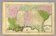
Southern States.
1 : 3500000 Olney, J. (Jesse), 1798-1872