Maps of Nuthampstead

A New and Correct Mapp of Middlesex, Essex and Hertfordshire
Bland, Joseph, Parker, Samuel, Smyth, Payler and Warburton, John
To the Nobility & Gentry of Essex
Pask, Joseph Robert Morden
Saffron Walden - OS One-Inch Map
1 : 63360 Topographic maps Ordnance Survey Ordnance Survey
London passenger transport map
Ordnance Survey
Great Dunmow (Hills) - OS One-Inch Revised New Series
1 : 63360 Topographic maps Ordnance Survey Ordnance Survey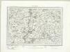
Great Dunmow (Outline) - OS One-Inch Revised New Series
1 : 63360 Topographic maps Ordnance Survey Ordnance Survey
Epping (Hills) - OS One-Inch Revised New Series
1 : 63360 Topographic maps Ordnance Survey Ordnance Survey
Epping (Outline) - OS One-Inch Revised New Series
1 : 63360 Topographic maps Ordnance Survey Ordnance Survey
Braintree
Although it was not obligatory to record archaeological sites until 1816, many draughtsmen displayed their interest in history by indicating them prior to this date. At Pleshey, to the centre-bottom of the plan, a dark circular form represents the prehistoric earthworks used by the Romans, Saxons and Normans as a defensive position. At Barrington Hall to the left of centre, near the top, the details of ornamental gardens and avenues of trees are shown, an indication of the meticulous nature of the Survey.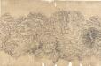
Chelmsford 8
Lines in pencil and red ink radiate from trigonometrical stations within the drawing and from the margins. Chelmsford is the largest settlement in the area. A straight, unmarked Roman road leads out from the city. The fact that the road is coloured yellow suggests it was still considered a major communication route. Three mills are marked on the River Chelmer. Marshland along the riverbanks is indicated by rows of dashes, differentiating it from the surrounding cultivated land. A lake and individual trees in the grounds of Moulsham Hall are recorded, towards the bottom of the landmass, a reminder of the meticulous nature of the Survey.
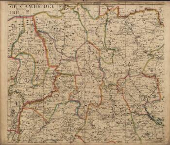
A topographical map of Hartford-Shire, 9
1 Blatt : 53 x 72 cm A. Dury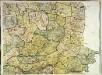
A topographical map of Hartford-Shire, 6
1 Blatt : 53 x 72 cm A. Dury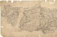
Epping
Pencil lines radiating from trigonometrical stations cover this drawing. They show the angles used for measuring distances and plotting topographical features. To the left of the map on Chestnut Common, the word 'flag' denotes the site of such a station. Hoddesden Park Wood and surrounding woodland are shown by individual trees with a line at the base, indicating shadow. This laborious technique was often replaced by a more generalised, stippled representation of treetops. The Lee River, running from Standstead at the top of this drawing, branches to form a canal leading down to the Powder Mills, which manufactured Gun Powder for shipping to London. Locks on the canal are shown in red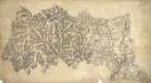
Buntingford
1 : 31680 Heavy brushwork interlining ('hachuring') depicting relief gives this map a three-dimensional quality. This elaborate hill shading and the attention given to communications routes conform to the military and cartographic standards employed by the Ordnance Survey. Buildings are infilled and blocked together in carmine at larger settlements, such as the historic town of Braughing towards the bottom of the plan. Braughing was strategically important due to its close proximity to three ancient roads: Icknield Way, Ermine Street and Stane Street. These roads were important for trade and communication. The dashed black-ink line which runs towards East End from the top-centre of the plan marks the boundary between Essex and Hertfordshire.
Anstey
1 : 31680 .This plan details the borders of Cambridgeshire, Essex and Hertfordshire. The close attention given to communication routes highlights the military emphasis of the Ordnance Survey. The River Cam is visible towards the right of the map, running from Ducksworth to Newport. Verron
Boxstead
1 : 31680 The draughtsman used Balsham Steeple and West Wickham Steeple at the top left of this plan as triangulation points. From these positions, he made angular observations with a theodolite to measure the height of the land and to plot individual topographical features. Pencil rays radiating from these two points,record the measurement process. Verron Charles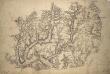
Ware 2
1 : 31680 .Much consideration is given in this map to the detailed representation of trees., Woodland could provide either hindrance or cover for a regiment on the move., Trees are drawn with small vertical stems and a shadow at the base., Planted avenues are depicted in this fashion at Ware Park, above Hartford, and Eastwich Hall, at the bottom of the map., A pattern of open dotting depicts the untilled agricultural land dominating the valleys of the Rivers Rib and Ash.
Chelmsford (Hills) - OS One-Inch Revised New Series
1 : 63360 Topographic maps Ordnance Survey Ordnance Survey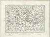
Chelmsford (Outline) - OS One-Inch Revised New Series
1 : 63360 Topographic maps Ordnance Survey Ordnance Survey
Braintree (Hills) - OS One-Inch Revised New Series
1 : 63360 Topographic maps Ordnance Survey Ordnance Survey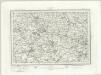
Braintree (Outline) - OS One-Inch Revised New Series
1 : 63360 Topographic maps Ordnance Survey Ordnance Survey
TL73 - OS 1:25,000 Provisional Series Map
1 : 25000 Topographic maps Ordnance Survey Ordnance Survey
TL72 - OS 1:25,000 Provisional Series Map
1 : 25000 Topographic maps Ordnance Survey Ordnance Survey
TL80 - OS 1:25,000 Provisional Series Map
1 : 25000 Topographic maps Ordnance Survey Ordnance Survey
TL63 - OS 1:25,000 Provisional Series Map
1 : 25000 Topographic maps Ordnance Survey Ordnance Survey
TL71 - OS 1:25,000 Provisional Series Map
1 : 25000 Topographic maps Ordnance Survey Ordnance Survey
TL62 - OS 1:25,000 Provisional Series Map
1 : 25000 Topographic maps Ordnance Survey Ordnance Survey
TL70 - OS 1:25,000 Provisional Series Map
1 : 25000 Topographic maps Ordnance Survey Ordnance Survey
TL61 - OS 1:25,000 Provisional Series Map
1 : 25000 Topographic maps Ordnance Survey Ordnance Survey