Maps of Sudbourne

Orford(002OSD000000026U00277000)
1 : 31680 This partly finished plan of the Suffolk coastline shows only roads and settlements to the left, but land use and relief detail have been added to the right. Original protraction lines remain in pencil: these represent the first plottings from the field book of the area. The handwritten note pasted at the bottom of the plan may have been trimmed from the margin. Metcalf, Edward B
Orford(002OSD000000026U00278000)
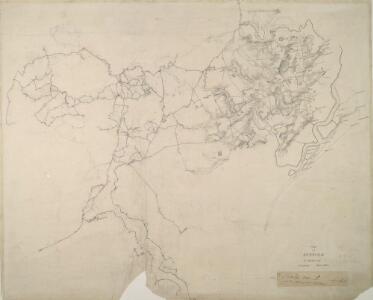
1 : 31680 This is an original protraction of the Suffolk coastline, running inland,from Orford Ness,,on the right,,to Hasketon and Wickham., The various traverses (single lines surveyed from different points),are distinguished by colour: red, blue, yellow, light brown and dark brown. ,These skeleton protraction lines,form the first plottings from the field book of the area., At the bottom right, the plan is annotated in blue with the date of the traverse and the,corresponding page numbers in the field book. Metcalf, Edward B
Woodbridge (Hills) - OS One-Inch Revised New Series
1 : 63360 Topographic maps Ordnance Survey Ordnance Survey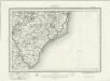
Woodbridge (Outline) - OS One-Inch Revised New Series
1 : 63360 Topographic maps Ordnance Survey Ordnance Survey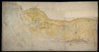
A Coloured Chart of the Coast of Suffolk, from Bawdseye to Thorpe, including Orford and Aldborough
This is a map of the Suffolk coast from Bawdseye to Thorpe. It includes detailed depictions of Orford and Aldeburgh. It is thought to date from between 1575-1600. Whimsically picturesque in style, topographical features are recorded pictorially. Individual architectural features such as Orford castle, village churches and windmills are carefully detailed and all manner of sailing vessels crowd the waterways. However, the purpose of the map is to provide a record of the layout and defensive capacity of the area. The inlets and tributaries of the waterways are recorded as are the sands and channels of the coast. Beacons are shown, with one atop the castle at Orford , built by Henry II in the 1160’s to guard what was then a busy port. The prominence of the windmills is probably due to the fact that they could also be used as vantage points due to their height. Aldeburgh (Albwrghe) is shown as a heavily fortified settlement with cannons occupying a pier and located at intervals along the adjacent sands. As well as two beacons, two windmills and a church are also shown at Aldeburgh all useful due to their height and therefore view of the sea. It is likely that the map was drawn in connection with the contemporary threat from Spain. Since the accession of the Protestant Elizabeth I to the English throne in 1558 Anglo-Spanish relationship had deteriorated. The continued English raids on Spanish colonial interests and England’s support of the Protestant rebellion in the Spanish ruled Netherlands had induced the Catholic Philip II to launch the 1588 Spanish Armada. Although the Spanish Armada was defeated by the English in 1588, England remained at war with Spain for many years and further attempts to invade were made by Philip of Spain with the dispersal of a second Armada’ in October 1596 and the assembly of the third Armada’ in the following spring. In this climate it was naturally coastal areas that were under the closest scrutiny.
TM35 - OS 1:25,000 Provisional Series Map
1 : 25000 Topographic maps Ordnance Survey Ordnance Survey
TM34 - OS 1:25,000 Provisional Series Map
1 : 25000 Topographic maps Ordnance Survey Ordnance Survey
TM25 - OS 1:25,000 Provisional Series Map
1 : 25000 Topographic maps Ordnance Survey Ordnance Survey
TM24 - OS 1:25,000 Provisional Series Map
1 : 25000 Topographic maps Ordnance Survey Ordnance Survey
TM44 - OS 1:25,000 Provisional Series Map
1 : 25000 Topographic maps Ordnance Survey Ordnance Survey
TM45 - OS 1:25,000 Provisional Series Map
1 : 25000 Topographic maps Ordnance Survey Ordnance Survey
Suffolk LX.NE & LXA.NW - OS Six-Inch Map
1 : 10560 Topographic maps Ordnance Survey Ordnance Survey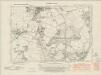
Suffolk LX.NE & LXA.NW - OS Six-Inch Map
1 : 10560 Topographic maps Ordnance Survey Ordnance Survey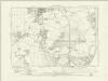
Suffolk LX.NE & LXA.NW - OS Six-Inch Map
1 : 10560 Topographic maps Ordnance Survey Ordnance Survey
Suffolk LX.NE & LXA.NW - OS Six-Inch Map
1 : 10560 Topographic maps Ordnance Survey Ordnance Survey
Suffolk LX.NE - OS Six-Inch Map
1 : 10560 Topographic maps Ordnance Survey Ordnance Survey
Suffolk LX.SE - OS Six-Inch Map
1 : 10560 Topographic maps Ordnance Survey Ordnance Survey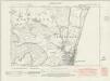
Suffolk LX.SE - OS Six-Inch Map
1 : 10560 Topographic maps Ordnance Survey Ordnance Survey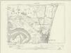
Suffolk LX.SE - OS Six-Inch Map
1 : 10560 Topographic maps Ordnance Survey Ordnance Survey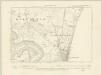
Suffolk LX.SE - OS Six-Inch Map
1 : 10560 Topographic maps Ordnance Survey Ordnance Survey
Suffolk LX.SE - OS Six-Inch Map
1 : 10560 Topographic maps Ordnance Survey Ordnance Survey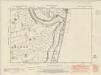
Suffolk LXIX.NE - OS Six-Inch Map
1 : 10560 Topographic maps Ordnance Survey Ordnance Survey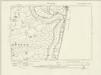
Suffolk LXIX.NE - OS Six-Inch Map
1 : 10560 Topographic maps Ordnance Survey Ordnance Survey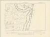
Suffolk LXIX.NE - OS Six-Inch Map
1 : 10560 Topographic maps Ordnance Survey Ordnance Survey
Suffolk LXIX.NE - OS Six-Inch Map
1 : 10560 Topographic maps Ordnance Survey Ordnance Survey
Suffolk LXIX.SE - OS Six-Inch Map
1 : 10560 Topographic maps Ordnance Survey Ordnance Survey
Suffolk LXIX.SE - OS Six-Inch Map
1 : 10560 Topographic maps Ordnance Survey Ordnance Survey
Suffolk LXIX.SE - OS Six-Inch Map
1 : 10560 Topographic maps Ordnance Survey Ordnance Survey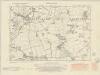
Suffolk LX.NW - OS Six-Inch Map
1 : 10560 Topographic maps Ordnance Survey Ordnance Survey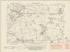
Suffolk LX.NW - OS Six-Inch Map
1 : 10560 Topographic maps Ordnance Survey Ordnance Survey
Suffolk LX.NW - OS Six-Inch Map
1 : 10560 Topographic maps Ordnance Survey Ordnance Survey
Suffolk LX.NW - OS Six-Inch Map
1 : 10560 Topographic maps Ordnance Survey Ordnance Survey