Maps of Forest of Dean

Chepstow
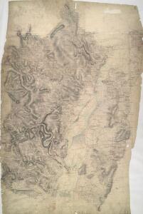
1 : 31680 Thomas Budgen surveyed the majority of the Welsh plans, and is probably author of this drawing of the Severn Estuary. The plan is a good example of the use of black and red ink to distinguish between wooden and masonry structures. Chepstow Bridge, on the River Wye, is illustrated with red piers and a black roadway. Budgen, Thomas
Chepstow (Hills) - OS One-Inch Revised New Series
1 : 63360 Topographic maps Ordnance Survey Ordnance Survey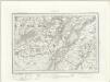
Chepstow (Outline) - OS One-Inch Revised New Series
1 : 63360 Topographic maps Ordnance Survey Ordnance Survey
Monmouth (Hills) - OS One-Inch Revised New Series
1 : 63360 Topographic maps Ordnance Survey Ordnance Survey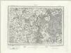
Monmouth (Outline) - OS One-Inch Revised New Series
1 : 63360 Topographic maps Ordnance Survey Ordnance Survey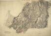
Chipping Sodbury
1 : 31680 The Avon barracks and battery are documented at the mouth of the River Severn, at the top of the map, protecting the Bristol Channel. Gravemounds ('Tumuli'), hill forts, ancient camps and antiquities are distinguished by the use of gothic lettering. The recording of archaeological details became obligatory in 1816. Quarries, kilns, mills, brickyards and pits dominate this industrial region of the West Midlands. According to a note in the Ordnance Survey Day Books, held in the National Archives, a one inch-to-the-mile reduction of this plan was delivered to Captain Gossett for engraving in the Drawing Office at the Tower of London in March 1830. Crocker, Edmund
SO51 - OS 1:25,000 Provisional Series Map
1 : 25000 Topographic maps Ordnance Survey Ordnance Survey
SO50 - OS 1:25,000 Provisional Series Map
1 : 25000 Topographic maps Ordnance Survey Ordnance Survey
ST59 - OS 1:25,000 Provisional Series Map
1 : 25000 Topographic maps Ordnance Survey Ordnance Survey
SO61 - OS 1:25,000 Provisional Series Map
1 : 25000 Topographic maps Ordnance Survey Ordnance Survey
ST58 - OS 1:25,000 Provisional Series Map
1 : 25000 Topographic maps Ordnance Survey Ordnance Survey
SO60 - OS 1:25,000 Provisional Series Map
1 : 25000 Topographic maps Ordnance Survey Ordnance Survey
ST69 - OS 1:25,000 Provisional Series Map
1 : 25000 Topographic maps Ordnance Survey Ordnance Survey
ST68 - OS 1:25,000 Provisional Series Map
1 : 25000 Topographic maps Ordnance Survey Ordnance Survey
Gloucestershire XXX - OS Six-Inch Map
1 : 10560 Topographic maps Ordnance Survey Ordnance Survey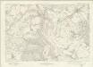
Gloucestershire XXXVIII - OS Six-Inch Map
1 : 10560 Topographic maps Ordnance Survey Ordnance Survey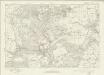
Gloucestershire XLVI - OS Six-Inch Map
1 : 10560 Topographic maps Ordnance Survey Ordnance Survey
Gloucestershire LIV - OS Six-Inch Map
1 : 10560 Topographic maps Ordnance Survey Ordnance Survey
Gloucestershire XXXI - OS Six-Inch Map
1 : 10560 Topographic maps Ordnance Survey Ordnance Survey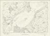
Gloucestershire LXII - OS Six-Inch Map
1 : 10560 Topographic maps Ordnance Survey Ordnance Survey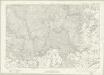
Gloucestershire XXXIX - OS Six-Inch Map
1 : 10560 Topographic maps Ordnance Survey Ordnance Survey
Gloucestershire LXVII - OS Six-Inch Map
1 : 10560 Topographic maps Ordnance Survey Ordnance Survey
Gloucestershire XLVII - OS Six-Inch Map
1 : 10560 Topographic maps Ordnance Survey Ordnance Survey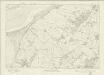
Gloucestershire LV - OS Six-Inch Map
1 : 10560 Topographic maps Ordnance Survey Ordnance Survey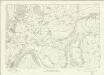
Gloucestershire XXXII - OS Six-Inch Map
1 : 10560 Topographic maps Ordnance Survey Ordnance Survey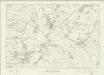
Gloucestershire LXIII - OS Six-Inch Map
1 : 10560 Topographic maps Ordnance Survey Ordnance Survey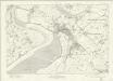
Gloucestershire XL - OS Six-Inch Map
1 : 10560 Topographic maps Ordnance Survey Ordnance Survey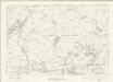
Gloucestershire LXVIII - OS Six-Inch Map
1 : 10560 Topographic maps Ordnance Survey Ordnance Survey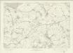
Gloucestershire XLVIII - OS Six-Inch Map
1 : 10560 Topographic maps Ordnance Survey Ordnance Survey