Maps of Winkleigh
South Molton, Devon
This relief on this drawing,is indicated by dense interlining ('hachures'), with,the summits of hills left blank. The drawing has been made on three pieces of paper mounted as one sheet., Dirty, worn and creased, the manuscript is difficult to decipher. ,A pencil note at the base of the drawing reads "To survey from * to * as ...by...the Farms as named."
South Molton
1 : 31680 This drawing is delicately shaded and subtly coloured, with yellow-tinted communication routes and red-ink stone buildings. Indistinct triangulation lines, corresponding to focal points of the drawing, appear on the reverse of the manuscript. A rough pencil circle is drawn around South Molton, the largest settlement in the area.
North Molton, Devon
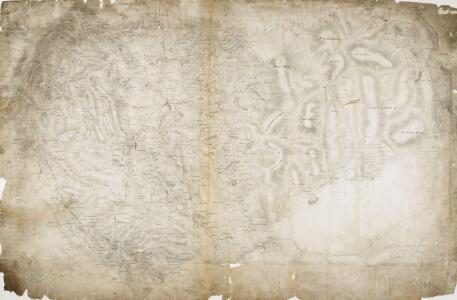
Much of this drawing,is dominated by,the open land of the downs.,Relief is indicated by shading and brushwork interlining ('hachures') but there is no numerical,record of trigonometrical altitudes. Paths on the moor are distinguished from roads by their pecked lines; roads,through villages are indicated by parallel lines. Hewitt, John
Tiverton, Devon
The Ordnance Survey drawings show a greater preoccupation with the lie of the land than earlier maps. Relative relief and natural cover were important considerations in the planning of military strategies. The heavy brushwork interlining ('hachuring') on this drawing makes many place names and details difficult to interpret. The Ex River is shown running through the area. Part of the river forms the county boundary between Devon and Somerset, shown here by a red dotted line.
Minehead
Relief is depicted in this drawing by short lines ('hachures') rendered in blue-grey watercolour. The boundary between cartography and landscape painting is bridged somewhat in drawings such as this. Many of the drawing instructors for the Ordnance Survey were accomplished artists. Main communication routes are coloured yellow and marked at intervals of one mile.
Chulmleigh (Hills) - OS One-Inch Revised New Series
1 : 63360 Topographic maps Ordnance Survey Ordnance Survey
Chulmleigh (Outline) - OS One-Inch Revised New Series
1 : 63360 Topographic maps Ordnance Survey Ordnance Survey
Barnstaple (Outline) - OS One-Inch Revised New Series
1 : 63360 Topographic maps Ordnance Survey Ordnance Survey
Barnstaple (Hills) - OS One-Inch Revised New Series
1 : 63360 Topographic maps Ordnance Survey Ordnance Survey
Dulverton (Outline) - OS One-Inch Revised New Series
1 : 63360 Topographic maps Ordnance Survey Ordnance Survey
Dulverton (Hills) - OS One-Inch Revised New Series
1 : 63360 Topographic maps Ordnance Survey Ordnance Survey
Tiverton (Outline) - OS One-Inch Revised New Series
1 : 63360 Topographic maps Ordnance Survey Ordnance Survey
Tiverton (Hills) - OS One-Inch Revised New Series
1 : 63360 Topographic maps Ordnance Survey Ordnance Survey
SS64 - OS 1:25,000 Provisional Series Map
1 : 25000 Topographic maps Ordnance Survey Ordnance Survey
SS63 - OS 1:25,000 Provisional Series Map
1 : 25000 Topographic maps Ordnance Survey Ordnance Survey
SS62 - OS 1:25,000 Provisional Series Map
1 : 25000 Topographic maps Ordnance Survey Ordnance Survey
SS74 & Parts of SS75 - OS 1:25,000 Provisional Series Map
1 : 25000 Topographic maps Ordnance Survey Ordnance Survey
SS61 - OS 1:25,000 Provisional Series Map
1 : 25000 Topographic maps Ordnance Survey Ordnance Survey
SS73 - OS 1:25,000 Provisional Series Map
1 : 25000 Topographic maps Ordnance Survey Ordnance Survey
SS72 - OS 1:25,000 Provisional Series Map
1 : 25000 Topographic maps Ordnance Survey Ordnance Survey
SS84 - OS 1:25,000 Provisional Series Map
1 : 25000 Topographic maps Ordnance Survey Ordnance Survey
SS71 - OS 1:25,000 Provisional Series Map
1 : 25000 Topographic maps Ordnance Survey Ordnance Survey
SS83 - OS 1:25,000 Provisional Series Map
1 : 25000 Topographic maps Ordnance Survey Ordnance Survey
SS82 - OS 1:25,000 Provisional Series Map
1 : 25000 Topographic maps Ordnance Survey Ordnance Survey
SS94 - OS 1:25,000 Provisional Series Map
1 : 25000 Topographic maps Ordnance Survey Ordnance Survey
SS81 - OS 1:25,000 Provisional Series Map
1 : 25000 Topographic maps Ordnance Survey Ordnance Survey
SS93 - OS 1:25,000 Provisional Series Map
1 : 25000 Topographic maps Ordnance Survey Ordnance Survey
SS92 - OS 1:25,000 Provisional Series Map
1 : 25000 Topographic maps Ordnance Survey Ordnance Survey
SS91 - OS 1:25,000 Provisional Series Map
1 : 25000 Topographic maps Ordnance Survey Ordnance Survey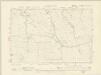
Somerset XXXII.SW & SE - OS Six-Inch Map
1 : 10560 Topographic maps Ordnance Survey Ordnance Survey