Maps of Parish of Saint Helier

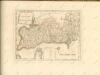
Jersey, the Haven
This is a map of Jersey entitled 'The Haven' on the reverse. It forms part of an atlas that belonged to William Cecil Lord Burghley, Elizabeth I’s Secretary of State. Burghley used this atlas to illustrate domestic matters. During the reign of Elizabeth Jersey was under scrutiny. After persistent rumours of a French attempt on Jersey, a survey of the island was ordered. In 1562 Richard Popinjay, the Portsmouth surveyor and military engineer, waspart of a commission led by Richard Worsley, the captain of the Isle of Wight, dispatched to study the fortifications of Jersey. [Popinjay, Richard]
Ordnance survey map of Jersey
1 : 31680 Jersey (Normanské ostrovy : ostrov) Ordnance survey office
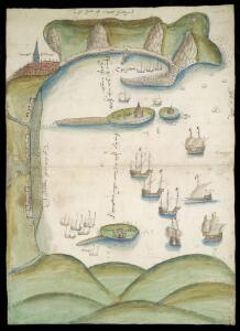
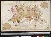
Copy of a Survey of the Island of Jersey, taken by order of his Grace the Duke of Richmond, Master-General of the Ordnance
1 : 10560 This drawing is formally titled at the bottom left and features scale bars at bottom centre and a compass star at top right. Thin and delicate brushwork ('hachuring') indicates relief, while symbols and different colours of wash indicate types of land use. Note the prominent positions of Mont Orgueil Castle above Granville Bay, at middle right, and Elizabeth Castle in the Bay of St. Hellier, at bottom centre. These give strategic indications as to how Jersey has defended its coastline through the ages. Thompson and Longmore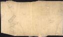
Sevenoaks (Kent) reverse
1 : 21120 Drawing on the reverse side of OSD 100,pt.1 (folio V, serial no. 353). Only the skeleton of a drawing is presented here. Pencil lines radiate from fixed points, representing angular measurements taken from trigonometrical stations.,Churches were often chosen for such stations, due to the clear views afforded by their tall towers or spires. On this map, an outlined red cross indicates a church, 'St Clements', with a windmill nearby.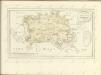
Nieuwe afteekening van het eijland Jarseij of Jarzee, Jerseij of Isle Gerseij, behoorende aen de Engelse, geleegen int Canaal aen de France kust bezuyde C. de la Hague
Jersey Gerard van Keulen
Carte de l'isle de Jersey
1 Karte : Kupferdruck ; 40 x 54 cm Bellin; Lempriere s.n.
Iarsay. [Karte], in: Atlas, sive, Cosmographicae meditationes de fabrica mundi et fabricati figura, S. 125.
1 Karte aus Atlas Mercator, Gerhard
Iarsey. [Karte], in: Novus atlas absolutissimus, Bd. 8, S. 115.
1 Karte aus Atlas Janssonius Offizin
Carte topo-hidro-graphique de l'isle de Jersey
1 Karte : Kupferdruck ; 64 x 43 cm Beaurain chez le chevalier de Beaurain rüe Git le Cœur la premiere porte à droite par le quay des Augustins
Iarsay. [Karte], in: Gerardi Mercatoris Atlas, sive, Cosmographicae meditationes de fabrica mundi et fabricati figura, S. 130.
1 Karte aus Atlas Mercator, Gerhard Montanus, Petrus
Channel Islands.
1 : 147840 Stanford, Edward
Sarnia insvla, vulgo Garnsey: et insvla Cæsarea, vernacule Iarsey
1 Karte : Kupferdruck ; 39 x 51 cm Blaeu Joan Blaeu
Channel Islands. (with) inset map of the English Channel.
1 : 82368 Tallis, J. & F.
126 Coutances.
1 : 86400 Cassini family; Cassini, Cesar-Francois, 1714-1784
SARNIA INSVLA, | Vulgo | GARNSEY: | et | INSVLA CÆSAREA, | Vernacule | JARSEY.
[Amsterdam : Joan Blaeu]
Sarnia Insula, Vulgo Garnsey: et Insula Caesarea, Vernacule Jarsey. [Karte], in: Le théâtre du monde, ou, Nouvel atlas contenant les chartes et descriptions de tous les païs de la terre, Bd. 4, S. 449.
1 Karte aus Atlas Blaeu, Willem Janszoon und Blaeu, Joan Blaeu, Willem Janszoon
[Coutances]
1 Blatt : 60 x 92 cm Defehrt s.n.
Sarnia Insula, Vulgo Garnsey: et Insula Caesarea, Vernacule Garsey. [Karte], in: Theatrum orbis terrarum, sive, Atlas novus, Bd. 4, S. 538.
1 Karte aus Atlas Blaeu, Joan Blaeu, Willem Janszoon
Sarnia Insula, Vulgo Garnsey: et Insula Caesarea, Vernacule Garsey. [Karte], in: Theatrum orbis terrarum, sive, Atlas novus, Bd. 4, S. 533.
1 Karte aus Atlas Blaeu, Joan Blaeu, Willem Janszoon
Remote British Isles: Jersey and Guernsey, Scilly Isles, Shetland Isles.
1 : 196000 Pinkerton, John, 1758-1826
Carte des isles Jersey Grenesey Aurigny et Cers
1 Karte auf 2 Blättern : Kupferdruck ; 67 x 89 cm Lattré chez Lattré graveur ordinaire du roi de M. le Duc d'Orléans et de la ville rue St. Jacques la porte cochere vis-à-vis celle de la parcheminerie à la ville de Bordeaux
Diocese de Coutances, [feuille 1 et 3]
2 Blätter : Dezauche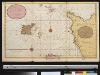
Een gedeelte van het Kanaal van Cherborgh tot t eijland Jerseij
France Gerard van Keulen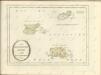

Carte générale, des isles Grenesey, Jersey, Aurigny, Chausey, &c
1 Karte : Kupferdruck ; 50 x 43 cm Beaurain chez le chevalier de Beaurain rue Git-le cœur la 1.ere porte en entrant par le quai des Augustins
Département de la Manche
1 Karte : Kupferdruck ; 41 x 34 cm Capitaine s.n.
Jersey, Guernsey.
1 : 364000 Faden, William, 1750?-1836