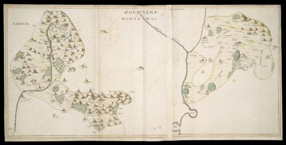
Maps of Buckton and Coxall
Map of Shropshire f.93
This is a manuscript map of Shropshire, one of four in the same style and hand. Its most interesting feature is the castle shown at Clun, which dominates the town. Other topographical features are limited to hills and trees, giving a general impression of the relief of the land and its coverage. It forms part of an atlas that belonged to William Cecil Lord Burghley, Elizabeth I's Secretary of State. Burghley used this atlas to illustrate domestic matters. Here Lord Burghley has added a place name adjacent the river, near to Lent Warden. Burghley was primarily interested in communication routes, an essential feature in any defence program for an area. Rivers were the most important of these communication routes as travel by water was often the fastest. Therefore a good knowledge of the locations along a particular river was essential for navigation and ultimately for the defence of the area. William Cecil, Lord Burghley
Actual Survey of the County of Salop
Rocque, John
Actual survey of the county of Salop, 3
1 Blatt : 71 x 53 cm John Rocque
Actual Survey of the County of Salop
Rocque, John
Actual survey of the county of Salop, 1
1 Blatt : 71 x 53 cm John Rocque
Bishop's Castle
1 : 31680 The River Clun Valley dominates the right-hand section of this plan of Shropshire. To the left is Clun Forest, famous for the sheep of the same name. The plan shows a section of the Offa's Dike running from top left towards bottom right. Extending 176 miles along the English border from the northern Welsh coast south to Chepstow,this great earth bank is eight miles longer than Hadrian's Wall. Unlike Hadrian's Wall, it was never garrisoned. Budgen, Thomas
Shrewsbury
1 : 31680 The drawing of this,plan was,begun in 1817 and completed in 1827.,,Because of,many erasures and corrections, the drawing is cracked and dirty, and therefore hard to read. An area calculation table survives in black ink,in the,bottom left margin. Stevens, Henry
Part of Shropshire containing 126 square miles. Surveyed and Drawn by H. Stevens R. M. D. 1816''
1 : 31680 .This is the first map to conform fully to the 1816 Ordnance Survey Circular, which stated that every plan was to,have an area title, survey and drawing date,,and a note of,its author's,name and rank.,The,map shows,a section of Offa's Dyke, the great earth bank running 176 miles along or near the English border from the North Wales coast south to Chepstow., Offa's Dyke is eight miles longer than Hadrian's Wall but, because it was not a stone construction, was never garrisoned., Its purpose was to mark rathen than defend the frontier. Stevens, Henry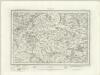
Montgomery (Outline) - OS One-Inch Revised New Series
1 : 63360 Topographic maps Ordnance Survey Ordnance Survey
Montgomery (Hills) - OS One-Inch Revised New Series
1 : 63360 Topographic maps Ordnance Survey Ordnance Survey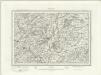
Welshpool (Outline) - OS One-Inch Revised New Series
1 : 63360 Topographic maps Ordnance Survey Ordnance Survey
Welshpool (Hills) - OS One-Inch Revised New Series
1 : 63360 Topographic maps Ordnance Survey Ordnance Survey
Oswestry (Hills) - OS One-Inch Revised New Series
1 : 63360 Topographic maps Ordnance Survey Ordnance Survey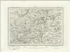
Oswestry (Outline) - OS One-Inch Revised New Series
1 : 63360 Topographic maps Ordnance Survey Ordnance Survey
Oswestry
1 : 31680 This drawing is formally titled. The scale of the drawing isgiven and the area of the land noted as 145.9838 square miles., A triangulation diagram appears on the reverse of the manuscript., This enabled draughtsmen to plot the exact location of topographical features., Archaeological sites are named in gothic script., Colour washes are combined with numerical annotations to indicate the relative relief and overall height of hills. Dawson, Robert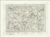
Wem (Outline) - OS One-Inch Revised New Series
1 : 63360 Topographic maps Ordnance Survey Ordnance Survey
Wem (Hills) - OS One-Inch Revised New Series
1 : 63360 Topographic maps Ordnance Survey Ordnance Survey
Shrewsbury (Hills) - OS One-Inch Revised New Series
1 : 63360 Topographic maps Ordnance Survey Ordnance Survey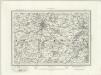
Shrewsbury (Outline) - OS One-Inch Revised New Series
1 : 63360 Topographic maps Ordnance Survey Ordnance Survey
Church Stretton (Hills) - OS One-Inch Revised New Series
1 : 63360 Topographic maps Ordnance Survey Ordnance Survey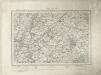
Church Stretton (Outline) - OS One-Inch Revised New Series
1 : 63360 Topographic maps Ordnance Survey Ordnance Survey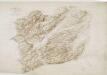
Meifod
1 : 31680 A triangulation diagram appears on the reverse of this drawing. This allowed draughtsmen to plot the exact location of prominent features of the landscape. Archaeological sites are named in gothic script.Black ink numbers indicate the heights of the hills. Still, Henry
SJ23 - OS 1:25,000 Provisional Series Map
1 : 25000 Topographic maps Ordnance Survey Ordnance Survey
SJ22 - OS 1:25,000 Provisional Series Map
1 : 25000 Topographic maps Ordnance Survey Ordnance Survey
SJ21 - OS 1:25,000 Provisional Series Map
1 : 25000 Topographic maps Ordnance Survey Ordnance Survey
SJ33 - OS 1:25,000 Provisional Series Map
1 : 25000 Topographic maps Ordnance Survey Ordnance Survey
SJ20 - OS 1:25,000 Provisional Series Map
1 : 25000 Topographic maps Ordnance Survey Ordnance Survey
SJ32 - OS 1:25,000 Provisional Series Map
1 : 25000 Topographic maps Ordnance Survey Ordnance Survey
SO29 - OS 1:25,000 Provisional Series Map
1 : 25000 Topographic maps Ordnance Survey Ordnance Survey