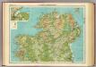
Maps of Fermanagh

A Coloured Representation, or Bird's-Eye View, of the Storm of "Eneskillin Castell"
This is a pictorial battle plan dating from 1594 of the 1592 siege of Eniskellen castle in Ireland. Although it is attributed Made and dun by John Thomas Solder’ nothing more is known about the draughtsman except that he drew a similar plan of the battle at Beleek the previous year. The activities of war are shown in great detail. It shows how the castle was taken using cannons in trenches, a greate bote’ with 67 men on board which was rowed round and anchored by the wall to breach it, and scaling ladders on the far side of the castle. In Governor Dowdalls Campe’ in the lower left of the drawing is The howse of munition’ and the heads of three rebels are displayed on posts. Thomas, John
Sheet 8 Fermanagh, uit: [Northern Ireland] : one-inch popular edition
1 : 63360 titelvariant: One-inch popular edition; One-inch popular series; Annotatie: Serietitel op omslag: One-inch popular series; Voor aanwezige bladen zie bladoverzicht; Sommige bladen met gaas verstevigd; Annotatie geografische gegevens: Met twee maatstokken (miles/yards en kilometres); Met indexkaartje op elk blad Belfast : Ordnance Survey of Northern Ireland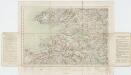
Sheet 4, uit: Ireland
1 : 253440 Annotatie: Voor aanwezige bladen zie overzichtsblad; Alle bladen met aantekeningen in kleurpotlood of inkt; Annotatie geografische gegevens: Maps on the scale of four miles to one inch; Op elk blad een diagram van aangrenzende bladen en een indexdiagram van de corresponderende bladen van de 'one inch map' Dublin : Ordnance Survey of Ireland
Vltoniae orientalis
1 : 316800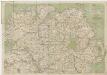
[Kaart], uit: Cycling map of Ireland : north sheet
1 : 400000 London : Bacon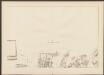
Ultoniae Orientalis. Pars [Karte], in: Atlas, sive, Cosmographicae meditationes de fabrica mundi et fabricati figura, S. 101.
1 Karte aus Atlas Mercator, Gerhard
Belfast
1 : 250000 Belfast (Severní Irsko) War Office
Ultoniae Orientalis. Pars [Karte], in: Gerardi Mercatoris Atlas, sive, Cosmographicae meditationes de fabrica mundi et fabricati figura, S. 94.
1 Karte aus Atlas Mercator, Gerhard Montanus, Petrus
Ulster
This is a map of the six ‘escheated’ counties of Ulster. It dates from 1609 and may be by John Norden, though likely to be based on the barony maps of Josias Bodley and William Parsons. It seems to be intended as a guide to planned plantings. In 1607 the earls of Ulster fled and the counties of Armagh, Cavan, Coleraine, Donegal, Fermanagh and Tyrone were confiscated by the English and the Scots. In 1608-9 the Commons had drafted plans for English and Scottish planting and lands that were to be retained by the Irish. Norden, John
Provincia Ultoniae = The province of Ulster
1 : 690000 Amstelodami : apud Joannem Janssonium
VLTONIA; | Hibernis CUI-GUILLY; | Anglis VLSTER.
[Amsterdam : Joan Blaeu]
Provincia Ultoniae The Province of Ulster [Karte], in: Gerardi Mercatoris et I. Hondii Newer Atlas, oder, Grosses Weltbuch, Bd. 1, S. 63.
1 Karte aus Atlas Mercator, Gerhard und Hondius, Jodocus Jansson, Jan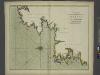
A chart of the NORTH-WEST coast of IRELAND from LOUGH SWILLY to SLYNE HEAD
from The sea-atlas : containing an hydrographical description of most of the sea-coasts of the known parts of the world.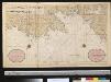
De NoordWest kust van IJrlandt van de eijlanden Ensterhull tot Broad Haven met alle desselfs havenen en gelegentheden
Ireland Gerard van Keulen
Provincia Ultoniae The Province of Ulster [Karte], in: Novus atlas absolutissimus, Bd. 8, S. 201.
1 Karte aus Atlas Janssonius Offizin
Ireland NW.
1 : 486830 Stanford, Edward
Vltonia; hibernis Cvi-Gvilly; anglis Vlster
1 Karte : Kupferdruck ; 40 x 48 cm Blaeu Joan Blaeu
Ireland NE.
1 : 486830 Stanford, Edward
Provincia Connachtiae = The province of Connaugt
1 : 790000 Amstelodami : ex officina Petri Schenk et Gerardi Valk
Ireland 2.
1 : 760320 Letts, Son & Co.
Provincia Connachtiae The Province of Connaugt [Karte], in: Gerardi Mercatoris et I. Hondii Newer Atlas, oder, Grosses Weltbuch, Bd. 1, S. 60.
1 Karte aus Atlas Mercator, Gerhard und Hondius, Jodocus Jansson, Jan
Provincia Connachtiae = The province of Connaugt
1 : 790000 Amstelodami : excudebat Joannes Janssonius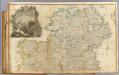
Ireland (north)
1 : 380000 Rocque, John
Provincia Connachtiae The Province of Connaugt [Karte], in: Novus atlas absolutissimus, Bd. 8, S. 198.
1 Karte aus Atlas Janssonius Offizin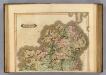
Ireland (northern)
1 : 700000 Lizars, Daniel
Parte del regno d'Irlanda, cioè le provincie di Connaught, e Munster
1 Karte : Kupferdruck ; 40 x 30 cm Zatta presso Antonio Zatta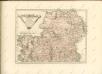

CONNACHTIA | Vulgo | CONNAUGHTY
[Amsterdam : Joan Blaeu]
Parte del regno d'Irlandia, cioè le provincie d'Ulster, e Leinster
1 Karte : Kupferdruck ; 40 x 30 cm Zatta; Zuliani; Pitteri presso Antonio Zatta