Maps of British Isles

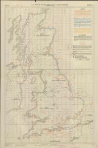
RAF map of Danger Areas in the United Kingdom (Permanent sites)
Great Britain War Office General Staff Geographical Section Ordnance Survey
A new map of Great Britain.
from The world described, or, A new and correct sett of maps : shewing the kingdoms and states in all the known parts of the earth, with the principal cities, and most considerable towns in the world ... / ... by Herman Moll, geographer ...
BRITANNIA | prout divisa suit temporibus | ANGLO-SAXONVM [...].
[Amsterdam : Joan Blaeu]
Firing ranges, UK
Great Britain War Office General Staff Geographical Section
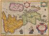
Britania et Hibernia
1 : 3000000 Irsko, ostrov Spruner, Karl von Justus Perthes
Britannia prout divisa suit temporibus Anglo-Saxonvm, præsertim durante illorum Heptarchia
1 Karte : Kupferdruck ; 40 x 30 cm, Bildgrösse 41 x 53 cm Blaeu Joan Blaeu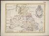
A new map of the Brittish Isles shewing their antient people, cities, and towns of note, in the time of the Romans
1 : 2846000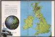
The British Isles
1 : 3000000 Debenham, Frank
Geology Of The British Isles.
1 : 1025000 Wyld, James, 1812-1887
Insularum Britannicarum acurata delineatio ex geographicis conatibus Abrahami Ortelii
1 : 2500000 Petrus Kaerius caelavit Amstelodami : apud Joannem Janssonium
Britannicarum insularum typus / ex conatibus geographicis Abrah. Ortelius
1 : 2500000 Annotatie: Oorspr. verschenen in: Theatrum Orbis Terrarum opus nunc denuo ... - [Antwerpen : Abraham Ortelius]; Origineel is Blad 24 in atlas factice; Annotatie geografische gegevens: West boven Ortelius, Abraham [Antwerpen : Arbraham Ortelius]
British Isles (outline)
1 : 4500000 Patteson, Edward
British Isles.
1 : 4500000 Patteson, Edward
Isles Britanniques.
1 : 2600000 Jouvet et Cie.
Grossbritanien.
1 : 3900000 Haller von Hallerstein, Friedrich; Reichard, C. G.
Die Britischen Inseln nach ihrer kirchlichen Eintheilung bis zur Reformation.
1 : 3000000 Spruner von Merz, Karl
Britannicarum Insularum Typus. [Karte], in: Theatrum orbis terrarum, S. 365.
1 Karte aus Atlas Ortelius, Abraham
Britische Inseln
Volksschul-Atlas über alle Teile der Erde Lange, Henry Druck und Verlag von Georg Westermann
Tabula novissima accuratissima regnorum Angliae, Scotiae Hiberniae
1 : 1850000 Irsko Seutter, Matthäus Mattheo Seutter
Composite: Grossbritannien.
1 : 1500000 Petermann, A.
British Isles. Pergamon World Atlas.
Polish Army Topography Service
Geographische Carte von Gross-Britannien zum Gebrauch beim Studium der Geschichte
Historisch-genealogisch-geographischer Atlas von Le Sage Las Cases, Emmanuel Auguste Dieudonné Marius Joseph de Johann Velten, Kunsthändler
Atlas für Handel und Industrie: Für Kaufleute, Fabrikante u. Gewerbetreibende, Handlungs- u. Gewerbe-Schulen

Insularum Britannicarum Acurata Delineatio [Karte], in: Gerardi Mercatoris et I. Hondii Newer Atlas, oder, Grosses Weltbuch, Bd. 1, S. 48.
1 Karte aus Atlas Mercator, Gerhard und Hondius, Jodocus Jansson, Jan
Nouvelle carte d'Angleterre, d'Ecosse et d'Irlande
1 Karte : Kupferdruck ; 44 x 49 cm Châtelain s.n.
Britannicæ insulæ
1 Karte : Kupferdruck ; 39 x 51 cm Sanson; Robert de Vaugondy chés le Sr. Robert geog. ord. du roy quay de l'horloge du Palais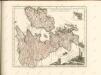

Die Britischen Inseln 1066 bis 1485.
1 : 3100000 Spruner von Merz, Karl