Maps of North Atlantic Ocean

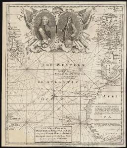
A new map or chart of the Western or Atlantic Ocean, with part of Europe Africa & America, showing the course of galleons, flota &c. to and from the West Indies
1 : 1800000 Bowen, Emanuel Cave, Edward
Chart of the Atlantic Ocean.
1 : 43000000 Melish, John
North Atlantic Ocean.
1 : 25000000 John Bartholomew & Co.
A new chart of the Atlantic or Western Ocean
1 : 9350000 Heather, W. (William) Heather, W. (William)
North Atlantic Ocean.
1 : 17500000 Johnston, Alexander Keith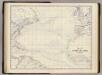
N. Atlantic Ocean.
1 : 19000000 Johnston, Alexander Keith, 1804-1871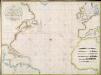
A new chart of the Atlantic or Western Ocean / improved by W. Heather; engraved by J. Stephenson.
from Charts and maps W. Heather; J. Stephenson,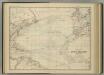
North Atlantic Ocean.
1 : 17500000 Johnston, Alexander Keith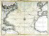
Nouvelle carte de l'ocean Atlantique et théatre de la guerre tant en Europe qu'en Amerique
1 Karte : Kupferdruck ; 52 x 71 cm Denis; Basset; Basset chés Basset rüe St. Jacques au coin de celle des Mathurins à l'image S.te Genevieve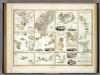
Specialia vom Vulkan Gurtel des Atlantischen Oceans.
Berghaus, Heinrich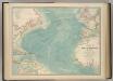
North Atlantic Ocean.
1 : 19000000 Johnston, W. & A.K.
Nord-Atlantischer Ocean.
1 : 28000000 Berghaus, Hermann
A new chart of the vast Atlantic Ocean: exhibiting the seat of war, both in Europe and America, likewise the trade winds & course of sailing from one continent to the other, with the banks, shoals and rocks drawn according to the latest discoveries, and regulated by astronomical observations / Emanl. Bowen, sculp.
from Atlantic Ocean Emannuel Bowen,
Portugal.
From [Series of advertising cards issued by Arbuckle Bros. Coffee Company, each consisting of a map of a country of the world with related illustrations.]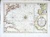
Carte de l'ocean occidental
1 Karte : Kupferdruck ; 31 x 44 cm Bellin Arkstée et Merkus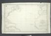
Carta general del Oceano Atlantico ú ocidental desde 52o de latitud norte hasta el Equador / construida de orden del Rey en el Deposito Hidrografico de Marina y presentada á S.M. por mano del Exmo. Señor D. Antonio Cornel, Secretario de Estado y del Despacho Universal de Guerra, Encargado del de Marina y de la Direccion General de la Real Armada.
from Atlantic Ocean D. Antonio Cornel,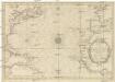
CARTE DE L'OCEAN OCCIDENTAL
1 : 6600000 Atlantský oceán-oblast Bellin, Jacques-Nicolas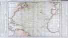
Carte générale de l'océan Atlantique ou Occidental
1 Karte : Kupferdruck ; 59 x 88 cm s.n.
Tableau des courants observés dans l'Océan Atlantique Septentrional, au moyen de bouteilles jetées à la mer. / dressé par P. Daussy, ingénieur hydrographe en chef de la Marine; gravé par Michel; écrit par J.M. Hacq.
from Atlantic Ocean P. Daussy; Michel; J.M. Hacq.,
Nieuwe wassende graade zee kaart over de Spaanse Zee vant kanaal tot t'eyland Cuba in Westindia = Nouvelle carte marine reduite de la Mer d. Espagne du canal jusqua Terra Neuf en I. de Cuba dans l'Amerique = The new sea map of the Spannish Zee betwext t' chanell and the I. Cuba / L.v. Anse, schulp.
from Charts and maps L.v. Anse; I. Cuba,
Chart of the Atlantic Ocean: with an illustration of the character and rout[e] of a storm which occurred on the American coast in August 1830 / William Hooker, engraver, New York.
from Atlantic Ocean William Hooker,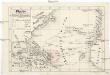
Plavby Krištofa [sic] Kolumba
Atlantský oceán-oblast
[A Chart of the Atlantic or Western Ocean] / Jones, sc.
from Charts and maps Jones,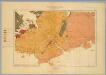
Province of Nova Scotia (Island of Cape Breton). Sheet no. 20.
1 : 63360 Geological Survey of Canada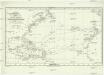
Chart shewing the tracks across the north Atlantic ocean of don Christopher Columbus
Atlantský oceán Toquet, H. Raban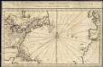
Carte de l'ocean occidental et partie de l'Amerique septentrionale
1 : 20000000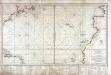
Carte réduite d'une partie de l'ocean Atlantique ou Occidental
1 Karte : Kupferdruck ; 46 x 81 cm Verdun de la Crenne; Borda; Pingré; Petit; Claret de Fleurieu s.n.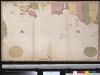
Niwe paskaard van de Spaanse Zee beginnende van Hitland of Eijsland en eijndigende aan Cabo Verde of de Zoute Eijlanden, lopende om de West tot aan de bancq van Terra Neuf, na de wassende graade paskaart gelegt
Atlantic Ocean Gerard van Keulen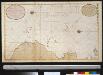
Wassende graade kaart van de Spaanse Zee van het Canaal tot voorbij de Vlaemse Eijlanden
Atlantic Ocean Gerard van Keulen