Maps of Nova Scotia
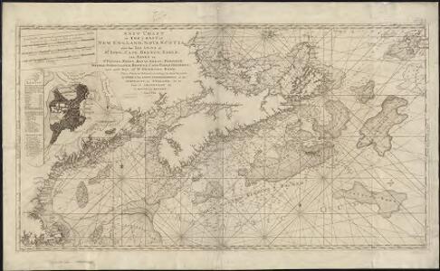
A new chart of the coast of New England, Nova Scotia, and the islands of St. Iohn, Cape Breton, Sable, the banks of St. Peters, Mizen, Banquereau, Porpoise, Middle, Sable Island, Browns, Cape Sable, Iefferys, and with part of St. Georges Bank
1 : 1200000 Keulen, Gerard Hulst van Keulen, Gerard Hulst van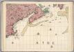
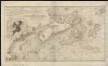
A Map of the British Empire in America. (Sheet 7).
1 : 2000000 Popple, Henry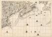
A Map of the British Empire in America. (Sheet 7).
1 : 2000000 Popple, Henry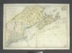
Carte réduite des côtes orientales de l'Amérique septentrionale: contenant celles des provinces de New-York et de la Nouvelle Angleterre, celles de l'Acadie ou Nouvelle Ecosse, de l'Île Royale de l'Île St. Jean, avec l'intérieur du pays dressée au Dépôt général des cartes, plans et journaux de la marine, pour le service des vaisseaux du roi, par ordre de M. de Sartine, conseiller d'Etat, ministre et secretaire d'Etat ayant le département de la marine / Petit, sculp.
from John H. Levine Collection M. de Sartine,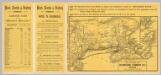
Intl. Steamship Co.'s routes.
1 : 3244000 International Steamship Company
Lower Canada ... and a large portion of the United States.
1 : 2154240 Arrowsmith, John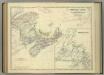
Eastern Canada.
1 : 2065500 Johnston, Alexander Keith
Canada, New Brunswick, Nova Scotia, &c., East Sheet.
1 : 2370000 Black, Adam & Charles
Various Regions and Cities in and around Maine including Canadian Maritime Provinces.
Shell Oil Company
New Map of Nova Scotia, New Brunswick and Cape Breton.
1 : 4200000 Morse, Jedidiah
Maine Central Railroad.
1 : 4200000 New England Railway Publishing Co.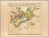
Nlle. Ecosse et Nouv. Brunswick. Amer. Sep. 44.
1 : 1641836 Vandermaelen, Philippe, 1795-1869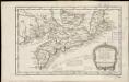
Carte de l'Acadie, Isle Royale, et Païs Voisins
1 : 2250000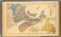
Geological map, Maritime Provinces.
1 : 1584000 Roe Brothers (Firm)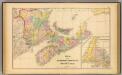
Maritime Provinces.
1 : 1584000 Roe Brothers (Firm)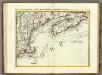
L'Acadia, le Provincie di Sagadahook e Main, la Nuova Hampshire.
1 : 2100000 Zatta, Antonio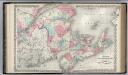
New Brunswick, Nova Scotia. Prince Edward Island. and Cape Breton Inland.
1 : 1500000 Colton, G.W.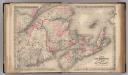
New Brunswick, Nova Scotia, Prince Edward Island, and Cape Breton Inland.
1 : 1500000 Colton, G.W.
The district of Main : from the latest surveys
1 : 2800000 Carleton, Osgood, 1742-1816 by Isaiah Thomas and Ebenezer T. Andrews
The district of Main : from the latest surveys
1 : 2900000 Carleton, Osgood, 1742-1816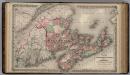
Dominion of Canada. Provinces of New Brunswick & Nova Scotia and Prince Edward Island.
1 : 1550000 Colton, G.W.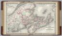
Canada. New Brunswick, Nova Scotia and Prince Edward island.
1 : 1500000 Colton, G.W.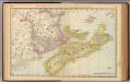
New Brunswick, Nova Scotia, and Prince Edward Island.
1 : 1730000 Rand McNally and Company
Nova Scotia, New Brunswick, and Prince Edward Island. Quebec.
1 : 1916000 Hammond, C.S.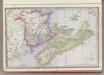
New Brunswick, Nova Scotia and Prince Edward Island.
1 : 1730000 Rand McNally and Company
Map of the province of Nova Scotia including Cape Breton Prince Edwards Island and part of New Brunswick
1 : 539000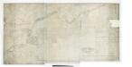
The north eastern coast of North America: from New York to Cape Canso, including Sable Island / by Edmunt Blunt, hydrographer; drawn & engraved by Charles Copley, N.Y.
from Parts Edmund Blunt; Charles Copley,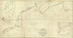
Composite: NE coast North America, N.Y. to Cape Canso.
1 : 910000 Wadsworth, A. S. (Alex. S.)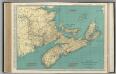
Nova Scotia, New Brunswick, and Prince Edward Island.
1 : 1140000 Rand McNally and Company