Maps of Roma Capitale
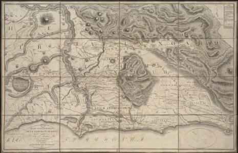
Plan topographique de la campagne de Rome
1 : 130000
Karte von Latium
Lazio (Itálie)
Latium
Lazio (Itálie) E. [sic] Tempsky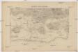
Karte von Latium
Lazio (Itálie) F. Tempsky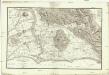
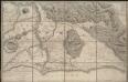
Plan topographique de la campagne de Rome
1 : 720000 Sickler, Friedrich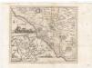
Campagna di Roma / Dom. Pronti fecit. In Roma presso Piale Neg. di Stampa e Carta a S. Cardo Alcorso
Pronti, D.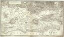
Contorni di Roma moderna
1 : 1000000 Westphal, G. E. Wolff, C. F. C.F. Wolff
Latium Vetus

Patrimonio di S. Pietro Sabina, et Ducato di Castro
1 : 210000 Mollova mapová sbírka Magini, Giovanni Antonio Magini, Fabio
Il Lazio, con le sue piu cospicue Strade Antiche e Moderne e principali casali e Tenute di esso
1 : 190000 Mollova mapová sbírka Ameti, Giacomo Filippo Homann, Johann Baptista - dědici
[Roma Vetus, Athenae, Urbs cum adjacentibus regionibus, Hierosolyma]
Schul-Atlas der alten Welt bei Justus Perthes
Roma e dintorni
1 : 100000 Řím (Itálie) Istituto geografico militare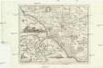
Campagna di Roma
Řím-oblast (Itálie) Lotter, Tobias Conrad Pronti, Domenico presso Piale neg. di stampe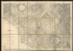
Roma e dintorni
1 : 100000 Istituto Geografico Militare (Firenze) Istituto Geografico Militare
Nova & Exacta Chorographia Latii Sive Territorii Romani
1 : 170000 Mollova mapová sbírka De Winter, Anthony Goeree, Jan Covens, Johannes I
Terretorii Romani Descrip. [Karte], in: Theatrum orbis terrarum, S. 309.
1 Karte aus Atlas Ortelius, Abraham Vrients, Jan Baptista
Terretorii Romani Descrip. [Karte], in: Theatrum orbis terrarum, S. 214.
1 Karte aus Atlas Ortelius, Abraham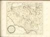

Territorii Romani Descrip. [Karte], in: Theatrum orbis terrarum, S. 85.
1 Karte aus Atlas Ortelius, Abraham
Campagna di Roma Olim Latium
1 : 270000 Mollova mapová sbírka Magini, Fabio Magini, Fabio
A plan of the environs of ancient Rome
1 : 412000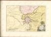

Ducatus Bracciani et Anguillariae Comitatus, Olim Sabatia. [Karte], in: Novus atlas absolutissimus, Bd. 5, S. 171.
1 Karte aus Atlas Janssonius Offizin
DVCATVS | BRACCIANVS, | olim | SABATIÆ REGIO.
[Amsterdam : Joan Blaeu]
Der Statt Rom grvndris vnd vorstellvng, wie der Zeit alle alte Rvnien, samt neven gebeven, Kirchen vnd Palatien, avfs Herrlichts erhoben vnd gezieret, vnter iezigem pabst Innoc. XI. anzvsehen sein
Řím (Itálie) Meyer, Johann
Colli Laziali
1 : 50000 Istituto geografico De Agostini-Novara
Città di Roma: Roma nel 1950 / Istituto Geografico Militare
Istituo Geografico Militare (Itàlia)
Tirreno-Italia. Foci del Tevere e litorale adjacente, piano dimostrativo delle variazioni della costa avvenute nelle diverse epoche
1 : 30000 Istituto idrografico della Marina. Gênes, Italie [Genova] : Istituto Idrografico della R. Marina
Foci del Tevere e litorale adiacente
1 : 30000 Istituto idrografico della R. Marina