Maps of Trentino-Alto Adige
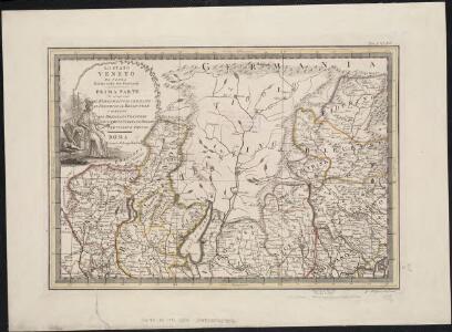
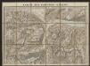
Lo Stato Veneto da terra diviso nelle sue provincie : prima parte che comprende Il Bergamasco Il Cremasco Il Feltrino Il Bellunese e porzioni del Bresciano Veronese Vicentino Padovano Dogado Trevisano e Friuli
1 : 1
Venezia
1 : 500000 Benátky (Itálie : oblast) Artaria di Ferd. Sacchi
Le Tyrol sous le nom duquel l'on comprend le comté de Tyrol, les comtés annexes de Bregentz, Feldkirck, Monfort, Pludentz, &c. et les evechés de Trente, et de Brixen
1 : 491000 Bludenz-oblast (Rakousko) Robert de Vaugondy, Didier Remondini, Giuseppe Remondini
Tyrolis pars meridionalis
1 : 218000 Trident (Itálie : provincie) Spergs, Ioseph de Homannianis Hered.
Territorio Di Trento [Karte], in: Le théâtre du monde, ou, Nouvel atlas contenant les chartes et descriptions de tous les païs de la terre, Bd. 3, S. 162.
1 Karte aus Atlas Blaeu, Willem Janszoon und Blaeu, Joan Blaeu, Willem Janszoon
Territorium Tridentinum [Karte], in: Novus atlas absolutissimus, Bd. 2, S. 223.
1 Karte aus Atlas Janssonius Offizin
TERRITORIO | DI | TRENTO.
Excudebat | Guiljelmus Blaeu.

Territorio Di Trento [Karte], in: Novus Atlas, das ist, Weltbeschreibung, Bd. 3, S. 154.
1 Karte aus Atlas Blaeu, Joan Blaeu, Willem Janszoon
Territorio Di Trento [Karte], in: Theatrum orbis terrarum, sive, Atlas novus, Bd. 3, S. 134.
1 Karte aus Atlas Blaeu, Joan Blaeu, Willem Janszoon
Territorium Tridentinum [Karte], in: Gerardi Mercatoris et I. Hondii Newer Atlas, oder, Grosses Weltbuch, Bd. 2, S. 228.
1 Karte aus Atlas Mercator, Gerhard und Hondius, Jodocus Jansson, Jan
[Reisekarte der Schweiz]
1 : 500000 1 Karte auf 6 Bl. gezeichnet v. H. Keller ; gest. v. J.J. Scheurmann [Füssli & Comp.], [Zürich]
Karte der Lombardischen und Süd-Tiroler-Alpen
1 : 250000 Ravenstein, Ludwig Ludwig Ravenstein
Carte de la Suisse avec les plans des cheflieux des 22 cantons
1 : 200000 1 Karte auf 8 Bl. dessinée et publié par Henri Keller ; Lithogr. von J. Schweizer = Charte der Schweiz mit den Grundrissen der Hauptorte der 22 Cantone Keller, Zürich
Wandkarte der Schweiz
1 : 200000 1 Karte auf 8 Blättern J.M. Ziegler Wurster, Winterthur
Territorio Di Brescia Et Di Crema [Karte], in: Gerardi Mercatoris et I. Hondii Newer Atlas, oder, Grosses Weltbuch, Bd. 2, S. 243.
1 Karte aus Atlas Mercator, Gerhard und Hondius, Jodocus Jansson, Jan
Territorio di Brescia et di Crema [Karte], in: Novus atlas absolutissimus, Bd. 5, S. 29.
1 Karte aus Atlas Janssonius Offizin
Trient
1 : 200000 1 Karte entworfen und bearbeitet von Woerl ; in Stein gestochen unter seiner Leitung ; Lithographie von B. Herder Herder, Freiburg im Breisgau
Distanzenkarte von der Schweiz
1 : 200000 1 Karte in 8 Teilen nach den besten Hülfsquellen bearb. von R. Huber Wagner, Bern
Viaggio da Milano a Venezia
1 : 1130000 Benátky (Itálie)
Territorio di Brescia et di Crema [Karte], in: Le théâtre du monde, ou, Nouvel atlas contenant les chartes et descriptions de tous les païs de la terre, Bd. 3, S. 108.
1 Karte aus Atlas Blaeu, Willem Janszoon und Blaeu, Joan Blaeu, Willem Janszoon
Territorio di Brecia et di Crema [Karte], in: Theatrum orbis terrarum, sive, Atlas novus, Bd. 3, S. 94.
1 Karte aus Atlas Blaeu, Joan Blaeu, Willem Janszoon
Neue Schweizerkarte von 1847
1 : 300000 1 Karte auf 4 Bl. als Wand- und Reliefkarte topisch und politisch dargestellt von Eduard Winckelmann Tobias Dannheimer, Kempten
Territorio di Brescia et di Crema [Karte], in: Novus Atlas, das ist, Weltbeschreibung, Bd. 3, S. 112.
1 Karte aus Atlas Blaeu, Joan Blaeu, Willem Janszoon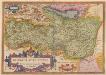
Bresciano Brixiani Agri Typus. Brixia, Cygnea supposita in specula. [Karte], in: Theatrum orbis terrarum, S. 204.
1 Karte aus Atlas Ortelius, Abraham
Bresciano Brixiani Agri Typus. Brixia, Cygnea supposita in specula. [Karte], in: Theatrum orbis terrarum, S. 299.
1 Karte aus Atlas Ortelius, Abraham Vrients, Jan Baptista
TERRITORIO | di | BRESCIA | et di | CREMA
Apud Guiljelmum | et Joannem Blaeu
Das Hertzogthum Mantova und Mirandola Sampt Angraentzenden Venedischen Laendern
1 : 500000 Mollova mapová sbírka Bodenehr, Gabriel Bodenehr, Gabriel