Maps of Eure-et-Loir

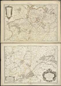
L'Evesché de Chartres dìvìsee en archìdìaconéz et doyennéz
1 : 211000
BELSIA, | Vulgo | LA BEAVSSE
G. Blaeu excudit
Belsia, Vulgo La Beausse. [Karte], in: Novus Atlas, das ist, Weltbeschreibung, Bd. 2, S. 51.
1 Karte aus Atlas Blaeu, Joan Blaeu, Willem Janszoon
Belsia, Vulgo La Beausse. [Karte], in: Theatrum orbis terrarum, sive, Atlas novus, Bd. 2, S. 65.
1 Karte aus Atlas Blaeu, Joan Blaeu, Willem Janszoon
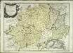
Belsia vulgo la Beavsse
1 Karte : Kupferdruck ; 35 x 47 cm Valck; Schenk apud Gerardum Valk et Petrum Schenk
Belsia, Vulgo La Beausse. [Karte], in: Le théâtre du monde, ou, Nouvel atlas contenant les chartes et descriptions de tous les païs de la terre, Bd. 2, S. 51.
1 Karte aus Atlas Blaeu, Willem Janszoon und Blaeu, Joan Blaeu, Willem Janszoon
Govvernement de Blois
1 Karte : Kupferdruck ; 11 x 15 cm Sebastian Cramoisy
Belsia vulgo la Beavsse
1 Karte : Kupferdruck ; 37 x 49 cm Blaeu G. Blaeu excudit
La Beauce
1 Karte : Kupferdruck ; 36 x 48 cm Mercator; Hondius Henricus Hondius
Partie Meridionale De L'Evesché De Chartres, Divisé En Archidiaconéz Et Doyennéz [Karte], in: Atlas nouveau, contenant toutes les parties du monde [...], Bd. 1, S. 102.
1 Karte aus Atlas Sanson, Nicolas Jaillot, Alexis Hubert und Mortier, Pieter
La Beauce. [Karte], in: Gerardi Mercatoris et I. Hondii Newer Atlas, oder, Grosses Weltbuch, Bd. 2, S. 68.
1 Karte aus Atlas Mercator, Gerhard und Hondius, Jodocus Jansson, Jan
Gouvernement de l'Orléanois
1 Karte : Kupferdruck ; 31 x 41 cm Mentelle; Tardieu; Dubuisson Mentelle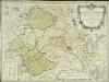
Nouvelle carte du gouvernement general d'Orleanois
1 Karte : Kupferdruck ; 49 x 65 cm Delafosse; Arrivet; Basset; Basset chez Basset rue St. Jacques
Belsia Vulgo La Beausse. [Karte], in: Novus atlas absolutissimus, Bd. 4, S. 115.
1 Karte aus Atlas Janssonius Offizin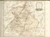
La Beauce
1 Karte : Kupferdruck ; 41 x 56 cm Sanson; Mariette; Somer chez Pierre Mariette rue St. Iacques a l'Esperance
La Beauce
1 : 360000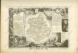

Département d'Eure et Loir
1 Karte : Kupferdruck ; 49 x 48 cm Houdan au bureau de l'atlas national de France rue Serpente n.o 15
La Beauce
1 Karte : Kupferdruck ; 41 x 56 cm Sanson; Robert de Vaugondy; Somer chez le Sr. Robert geographe du roy quai de l'Horloge du Palais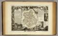
Dept. De L'Eure et Loir.
1 : 568000 Levasseur, Victor.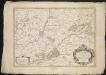
L'Evesché de Blois, divisé en Archidiaconéz et Doyennéz
1 : 266000
L'Evesché de Blois, divisé en Archidiaconéz et Doyennéz
1 : 211000
Perchensis Comitatus La Perche Comté [Karte], in: Novus Atlas, das ist, Weltbeschreibung, Bd. 2, S. 106.
1 Karte aus Atlas Blaeu, Joan Blaeu, Willem Janszoon
Perchensis Comitatus La Perche Comte [Karte], in: Novus atlas absolutissimus, Bd. 4, S. 118.
1 Karte aus Atlas Janssonius Offizin
Perchensis Comitatus La Perche Comté [Karte], in: Le théâtre du monde, ou, Nouvel atlas contenant les chartes et descriptions de tous les païs de la terre, Bd. 2, S. 104.
1 Karte aus Atlas Blaeu, Willem Janszoon und Blaeu, Joan Blaeu, Willem Janszoon
Perchensis Comitatus La Perche Comté [Karte], in: Theatrum orbis terrarum, sive, Atlas novus, Bd. 2, S. 70.
1 Karte aus Atlas Blaeu, Joan Blaeu, Willem Janszoon
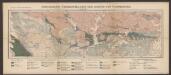
15) V.S.O. ''Le Mans'', uit: Carte géologique de France
1 : 500000 Annotatie: Voor aanwezige bladen zie bladoverzicht [S.l : s.n.]
Perchensis comitatvs
2 Karten auf 1 Blatt : Kupferdruck ; Bildgrösse 39 x 50 cm Janssonius; Du Temps Joannes Janssonius