Maps of Arlington County

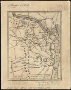
Washington & its vicinity
1 : 18100 J.H. Bufford's Lith.
Strategic War Points of the United States no.4: city of Washington and District of Columbia
Strategic War points of the United States no.4: city of Washington and District of Columbia J. Wyld
Strategic War Points of the United States no.4: city of Washington and District of Columbia
Strategic War Points of the United States no.4: city of Washington and District of Columbia J. Wyld
Maps of the Eastern, Middle and Southern States: Washington
Map of Washington. L. Prang & Co.
District of Columbia
1 : 120000 Bradford, Thomas G.
Topographical map of the District of Columbia and a portion of Virginia
1 : 15840 Greene, F. V. (Francis Vinton), 1850-1921 [s.n.]
Defenses Washington.
1 : 47520 Whiting, H. L.
Spot map showing residences of juvenile delinquents in the District of Columbia as of July 1, 1935
1 : 19200 [s.n.]
Base map of the District of Columbia showing railroads, main thoroughfares, alley blocks, and public (government) buildings
1 : 19000 District of Columbia. Office of the Surveyor [s.n.]
Base map of the District of Columbia showing public and zoning areas
1 : 19200 District of Columbia. Office of the Surveyor Engineer Commissioner
Falls Church
1 : 24000
Falls Church
1 : 24000
Falls Church
1 : 24000
Falls Church
1 : 24000
Falls Church
1 : 24000
Falls Church
1 : 24000
Falls Church
1 : 24000
Falls Church
1 : 24000
Falls Church
1 : 24000
Falls Church
1 : 31680
Falls Church
1 : 31680
Annandale
1 : 24000
Annandale
1 : 24000
Annandale
1 : 24000
Annandale
1 : 24000
Annandale
1 : 24000
Annandale
1 : 24000
Annandale
1 : 24000
Annandale
1 : 24000
Annandale
1 : 24000
Annandale
1 : 24000
Annandale
1 : 31680