Maps of Argentina

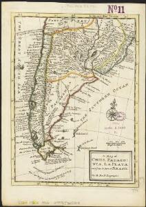
A map of Chili, Patagonia, La Plata and ye south part of Brasil
1 : 18000000
Typus Geographicus, CHILI PARAGUAY FRETI MAGELLANICI &c
1 : 1480000 Chile Delisle, Guillaume Beauchesne-Gouin de Homannianis Heredibus
230-231. South America, South. The World Atlas.
1 : 7500000 USSR (Union of Soviet Socialist Republics).
Carte du Paraguay, du Chili, du Detroit de Magellan &c.
1 : 93442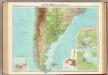
South America - southern section.
1 : 10000000 John Bartholomew and Son
United Provinces, Chili & Patagonia.
1 : 16473600 Burr, David H., 1803-1875
Southern South America. Pergamon World Atlas.
1 : 10000000 Polish Army Topography Service
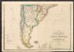
Map of Chili, Patagonia, La Plata, part of Brasil.
1 : 18000000 Moll, Herman, d. 1732
Le Paraguayr, Le Chili, La Terre, et les Isles Magellanicques
1 : 14000000
Typus Geographicus Chili & Paraguay
1 : 9000000 Esta es una adaptación de la empresa Homann Heirs (también es conocida como Homann Erben, o herederos de Homann, en castellano) de diversos mapas del cono sur de América publicados en Francia a principios del siglo XVIII. Incluye un plano de la ciudad de Santiago de Chile. La empresa Homann Heirs fue creada tras la muerte de Johann Baptiste Homann (1664-1724), famoso Geógrafo del Sacro Imperio Romano Germánico. A mediados del siglo XVIII la empresa estaba dirigida por el geógrafo Johann Michael Franz y por el grabador Johann Georg Ebersberg hijastro de Johann Baptiste Homann. La empresa funcionó en Núremberg hasta 1848 produciendo múltiples obras de geografía, atlas y mapas. Homann Erben (Empresa) L'Isle, Guillaume de (1675-1726)

Amerique du Sud (Partie Medionale).
1 : 13575000 Migeon, J.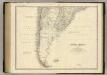
South America S.
1 : 8989200 Johnston, Alexander Keith, 1804-1871
Buenos Ayres, Chili & Patagonia.
1 : 14000000 Greenleaf, Jeremiah
United Provinces, Chili & Patagonia.
1 : 14000000 Greenleaf, Jeremiah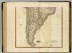
South America south.
1 : 10500000 Cary, John, ca. 1754-1835
Carte du Paraguay, du Chili, du Detroit de Magellan &c.
1 : 9300000 dressée sur les descriptions des P.P. Alfonse d'Ovalle, et Nicolas Techo [...] par Guillaume de l'Isle [...] A Amsteldam : chez Iean Cóvens et Corneille Mortier, Geographes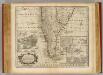
Chile, Terra del Fuego &c.
1 : 11000000 Bowen, Emanuel
Süd-America in zwei Blättern
Hand-Atlas über alle Theile der Erde nach dem neuesten Zustande und über das Weltgebäude Stieler, Adolf bei Justus Perthes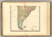
(South America southern half).
1 : 10200000 Tanner, Henry S.
Mapa de la Republica Argentina
1 : 8500000 Oficina meteorologica nacional. Buenos Aires [Buenos Aires] : Tall. de la Officina Meteorologica
Der Südliche Theil von Süd-America
Hand-Atlas über alle Theile der Erde nach dem neuesten Zustande und über das Weltgebäude Stieler, Adolf bei Justus Perthes
United Provinces, Chili, Patagonia.
1 : 18000000 Grigg, John
Carte du Paraguay, du Chili, Détroit de Magellan, & Terre de Feu: dans l'Amérique méridionale
1 : 4600000 [Amsterdam] : par la veuve de Nicolas Visscher
Der südliche Theil von Süd-America enthaltend Bolivia, das südliche Brasilien, Paraguay, La Plata Staaten, Chile und die Südspitze
1 : 7600000 entw. u. gez. vom Pr. L. v. Stülpnagel Hase sc. Gotha : Perthes
South America and West Indies.
1 : 10500000 Tanner, Henry S.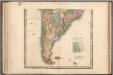
South America and West Indies.
1 : 10500000 Tanner, Henry S.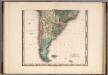
South America and West Indies. 1818
1 : 10500000 Tanner, Henry S.
Chili, Plata, et Patagonie.
1 : 15000000 Malte-Brun, Conrad, 1775-1826