Maps of South America

America meridionalis
1 : 538560
Amerique Meridionale
Nicolas de Fer (1646-1720) fue uno de los principales exponentes del desarrollo de la cartografía francesa de principios del siglo XVIII, caracterizada por una orientación estética más sobria y un énfasis en los criterios científicos de la producción cartográfica. Por ello llama la atención que en este mapa del continente suramericano de Fer parece aferrarse a nociones cartográficas desactualizadas a finales del siglo XVIII, como la existencia de un vasto continente en cercanías de la Tierra del Fuego. Fer, Nicolas de (1646-1720) Robbe, Jacques (1643-1721); Guérard, Nicolas, (ca. 1648-1719) Dezallier, Antoine, (1642?-1716)
218-219. South America, Physical. The World Atlas.
1 : 20000000 USSR (Union of Soviet Socialist Republics).
Sud-Amerika.
1 : 30000000 Steinmann, G.

Map of Brazil, Bolivia, Paraguay, and Uruguay ; Harbor of Rio Janeiro [inset]; Harbor of Bahia [inset]; Map of Chili ; Island of Juan Fernandez [inset].
from New general atlas.
Neuer Atlas der ganzen Erde nach den neuesten Bestimmungen für Zeitungsleser

221-222. South America, Political. The World Atlas.
1 : 20000000 USSR (Union of Soviet Socialist Republics).
Jižní Amerika

A map of South America containing Tierra-Firma, Guayana, New Granada, Amazonia, Brasil, Peru, Paraguay, Chaco, Tucuman, Chili and Patagonia / from Mr. D'Anville with several improvements and additions and the newest discoveries
1 Mapa, col. Anville, J.B. d' ; Laurie & Whittle published by Laurie & Whittle as the Act directs
America Meridionalis [Karte], in: Gerardi Mercatoris Atlas, sive, Cosmographicae meditationes de fabrica mundi et fabricati figura, S. 559.
1 Karte aus Atlas Mercator, Gerhard Montanus, Petrus
South America.
1 : 22809600 Johnson, A.J.
L'Amerique selon l'etendue de ses principales parties, 2
1 Blatt : mehrfarbig ; 49 x 61 cm Martin Will
Map of South America.
1 : 15400000 Finley, Anthony
Jižní Amerika.


Jižní Amerika
Jižní Amerika
Map of South America.
1 : 23000000 Winterbotham, W.
South America.
1 : 50000000 Adams, Daniel
Süd America
1 : 41700000 Jižní Amerika Biller, Franz
South America.
1 : 50000000 Adams, Daniel
Amerique Meridionale divisée en ses principales parties ou sont distingués les vns des autres les estats suivant qu'ils appartiennent presentement aux François, Castillans, Portugais, Hollandois, &c
1 : 1600000 Jižní Amerika Sanson, Nicolas Jaillot, Alexis-Hubert chez H. Iaillot
America Meridionalis
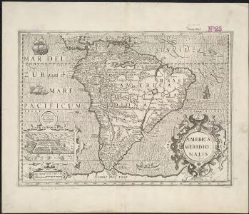
Waesbergen, yerno del famoso cartógrafo Johannes Janssonnius, heredó algunas planchas de grabado usadas por el taller cartográfico de la familia de los Hondius a principios del siglo XVII. Aunque estas planchas estaban bastante desactualizadas, permitían imprimir atlas de bajo costo que suplían un creciente mercado cartográfico. Esta reimpresión de un mapa, originalmente publicado en la década de 1620, representaba todavía la Tierra del Fuego como la parte norte de un vasto continente austral, pese a que desde la década de 1630 se supiera –gracias a los propios holandeses- que ésta solo era una pequeña isla al extremo sur del continente americano. Otros elementos interesantes del mapa son: la presencia de un gigante patagón en el cono sur del continente y el mítico Lago Parime en la región de las Guayanas. El mito de la existencia de gigantes y de la ciudad del Dorado en el Lago Parime, se mantuvo hasta el siglo XVIII. Waesberger, Jan Jansson van (fl. 1661 - 1681) Keere, Pieter van der (1571 – c.1646) Jan Jansson van Waesberger (fl. 1661 - 1681)
Carte Physique de L'Amérique du Sud
1 : 2000000 Description géographique et statistique de la Confédération Argentine Martin de Moussy, Victor Librairie de Firmin Didot frères, fils et Cie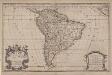
South America divided into its principall parts where are distinguished the severall states which belong to the Spanish, English, Portugals, and French
1 : 16000000 Berry, William, fl. 1669-1708 Sold by William Berry at the sign of the Globe between Charing-Cross and White-Hall
South America.
1 : 48000000 Seaman, James V.
Süd-Amerika
Adolf Stieler's Handatlas über alle Theile der Erde und über das Weltgebäude Stieler, Adolf Justus Perthes
South America
1 : 22620000
Sud-America.
1 : 75000000 Brudin, J. L.; Stieler, Adolf