Maps of Sahara

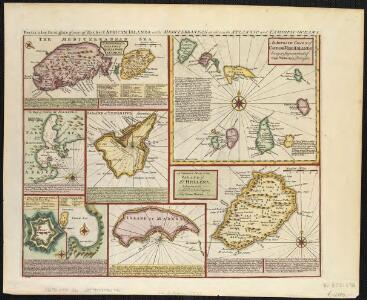
Particular draughts of some of the chief African Islands in the Mediterranean, as also in the Atlantic and Ethiopic Oceans
1 : 1
Africa.
1 : 30000000 Jefferys, Thomas
Africa (blank)
1 : 30000000 Jefferys, Thomas
Africa.
1 : 30096000 Lucas, Fielding Jr.
Africa.
1 : 21542400 Fullarton, A. & Co.
6-8. Linee di comunicazione, oceano Indiano, Pacifico.
1 : 30000000 Touring club italiano
Senegambien, Sudan, Guinea.
1 : 14700000 Berghaus, Heinrich; Flemming, Carl; Sohr, Karl
Mittel- und Nord-Africa und Arabien. Westliches Blatt
Stieler's Hand-Atlas Stieler, Adolf bei Justus Perthes
West Africa.
1 : 15000000 Colton, G.W.
North Western {LF}{LF}Africa
1 : 15000000 Colton, G.W.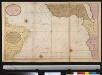
De zeekusten van Gunea van C. Verde tot Cabo de Bona Esperanco als mede de kusten van Brasil op wassende grade
Atlantic Ocean Gerard van Keulen
Nigritarum Regnum. [Karte], in: Novus atlas absolutissimus, Bd. 6, S. 171.
1 Karte aus Atlas Janssonius Offizin
Mittel- und Nord-Africa, westl. Theil
Composite: La Guinee.
1 : 9000000 Bonne, Rigobert, 1727-1794
Afrique du N.O.
1 : 10000000 Vivien St Martin, L.
West Africa.
1 : 18000000 Arrowsmith, Aaron; Lewis, Samuel
West Africa.
1 : 18000000 Arrowsmith, Aaron; Lewis, Samuel

North Western Africa.
1 : 15000000 Colton, G.W.
Paskaart van Gvinea van C. Verde tot R. de Galion
1 Karte : Kupferdruck ; 43 x 53 cm Doncker bÿ Hendrick Doncker in de Nieuwebrugsteeg
[Mittel- und Nord-Africa, Westl. Theil]
Hand-Atlas über alle Theile der Erde nach dem neuesten Zustande und über das Weltgebäude Stieler, Adolf bei Justus Perthes
West Africa.
1 : 15000000 Colton, G.W.
Mittel- & Nord-Afrika, Westl. Theil
Handatlas über alle Theile der Erde und über das Weltgebäude Stieler, Adolf Justus Perthes
[Mittel- und Nord-Africa, Westl. Theil]
Hand-Atlas über alle Theile der Erde und über das Weltgebäude Stieler, Adolf Justus Perthes
Das nordwestliche Africa
1 : 8000000 Afrika severozápadní Gräf, Carl Geographisches Institut
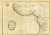
Carte de la Barbarie [d]e la Nigritie et de la Guinée
1 : 9150000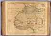
Barbarie, Nigritie, Guinee.
1 : 9200000 L'Isle, Guillaume de, 1675-1726
Barbarie, Nigritie, Guinee.
1 : 9200000 L'Isle, Guillaume de, 1675-1726
Mittel-& Nord-Afrika, Westl. Theil.
1 : 14000000 Stulpnagel, F.v.