Maps of Shanwei City
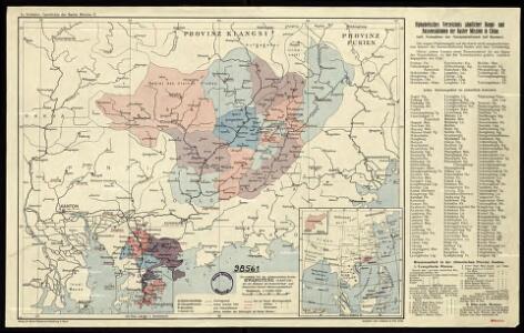
The northeastern part of the southern Chinese province Kwang Tung (Canton) with the mission stations of the Basel, Berlin and Rhenish (Barmer) Mission Societies.
七省沿海形勝圖 : 南日嶼至三央口
1 : 1500000 七省沿海形勝圖 民国十五年(1926年)再版,童世亨,上海:商務印書館 此图资料来自山阴朱吉臣在沿海地区进行的实地勘察,但图未及出版,朱吉臣便离世,勘察手稿经交由童世亨,但不幸在日本遗失,仅留部分,后童世亨根据日本邮船会所刊行的航海图,结合朱吉臣残稿及浙江、福建、广东舆图整理绘制成此图。民国三年初版,十五年再版。共有5图:1、《自鴨綠江至東楮島》, 2、《自東楮島至吳淞口》, 3、《自吳淞口至南日嶼》,4、《自南日嶼至三夾口》,5、《自三夾口至白龍尾》,北起鸭绿江,一路南下经辽东半岛、渤海湾、山东半岛、江苏、浙江、福建、广东沿海,过雷州半岛至北部湾,涵盖整个中国东部海岸地带,细致绘制了海岸线和海岛。标注了涨潮和退潮方向、水道、灯塔、灯船、浮筒灯,并用绿色数字标注近海各处的水深。同时,以插图形式绘制了沿海主要港口、河口、海湾和城市,包括《旅順口分圖》《威海衛分圖》《膠州灣分圖》《雲台山分圖》《鎮江分圖》《江陰分圖》《吳淞口分圖》《舟山群島及象山港分圖》《三門灣分圖》《甌江口分圖》《沙埕港分圖》《三都墺分圖》《閩江口分圖》《廈門港分圖》《汕頭港分圖》《香港九龍分圖》《澳門附近分圖》《廣州附近分圖》及《廣州灣分圖》。用红色字体标注港口被列强侵占的情况。 5图,彩印,中文,39.5 x 54.5 cm,约1:1,500,000,E108°-124°/ N16°-41° Harvard-Yenching | 3080 0140.49 Oversize;Hollis Number:009201036 童世亨 上海:商務印書館
General map of the region worked on by the Basel Mission in Canton Province, China.
Lörcher, J.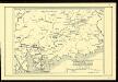
The northeastern part of the Southern Chinese Province Kwangtung (Canton) with the mission stations of the Basel, Berlin and Rhenish (Barmer) missions.
The Canton River
Chinese Province of Kwangtung

Lung-ch'uan
1 : 2500000 United States. Army Map Service. Army Map Service
Ho-yüan
1 : 2500000 United States. Army Map Service. Army Map Service
Mei-hsien
1 : 2500000 United States. Army Map Service. Army Map Service
Shan-t'ou
1 : 2500000 United States. Army Map Service. Army Map Service
Atlas der evangelischen Missionsgesellschaft in Basel mit Angabe der Verbreitung der Hauptreligionen11. Der Sinon oder Sanon-Kreisder Chinesischen Provinz Canton

Logong and surrounding areas
Lörcher, J.
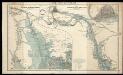
Karte des Hafens von Canton mit Macao, Whampoa, der Bocca Tigris und allen umliegenden Inseln
1 : 310000 nach der so eben in London erschienenen Karte des Herrn James Wyld gedruckt b. Rauh ; Lith. v. Geiger Wien : Verlag der Kunsthandlung H.F.M
Der Sinon od. Sanon-Kreis der chinesischen Provinz Canton
Atlas der evangelischen Missions-Gesellschaft zu Basel Locher; Gross, Rudolf Im Verlag des Comptoires der evangelischen Missions-Gesellschaft
Map of the Canton Province districts of Tunkon, Sinon and Kwuisen, including the British colony Hongkong.

Hong Kong
1 : 2500000 United States. Army Map Service. Army Map Service
Lu-feng
1 : 2500000 United States. Army Map Service. Army Map Service
Ch'ü-chiang
1 : 2500000 United States. Army Map Service. Army Map Service
Kuang-chou
1 : 2500000 United States. Army Map Service. Army Map Service
Kanton und Kantonstrom
1 : 800000 Kanton (Čína) F.A. Brockhaus' geogr.-artist. Anstalt
Hsia-men
1 : 2500000 United States. Army Map Service. Army Map Service
Chao-an
1 : 2500000 United States. Army Map Service. Army Map Service
Amoy and surrounding region, China (1902)
Map of Amoy and surrounding region, which includes Heng-Hoa, Chin-Chew, Chang-Chew, Eng-Chhun, Lung-Yen, and the district round each year, by Rev.L.W.Kip, D.D. London : Unwin Brothers
Chung-shan
1 : 2500000 United States. Army Map Service. Army Map Service
Map of the Sun-On District (Kwangtung Province)

untitled
J. Dilger
Map of the Hongkong and Lilong mission areas.
J. Dilger
Hong Kong and the Territory Leased to Great Britain

Hongkong and the New Territories