Maps of North Atlantic Ocean

Untitled

[Afrika, Blatt 1]
Adolf Stieler's Handatlas über alle Theile der Erde und über das Weltgebäude Stieler, Adolf Justus Perthes
Nieuwe afteekening van de Spaanse Zee van het Canaal tot Cabo Verde
Atlantic Ocean Gerard van Keulen
De cust van Barbaria, Gualata, Arguyn, en Geneheo, van Capo Verde.
from De zee-atlas ofte water-wereld : waer in vertoont werden alle de zee-kusten van het bekende des aerd-bodems : seer dienstigh voor alle heeren en kooplieden, als oock voor alle schippers en stuurlieden / by Pieter Goos.
Prima Affrice Tabula [Karte], in: [Clavdii Ptholomei Cosmographi ...], S. 287.
1 Karte aus Atlas Nicolaus Germanus [und Ptolemaeus, Claudius]
Niwe paskaard van de Spaanse Zee beginnende van Hitland of Eijsland en eijndigende aan Cabo Verde of de Zoute Eijlanden, lopende om de West tot aan de bancq van Terra Neuf, na de wassende graade paskaart gelegt
Atlantic Ocean Gerard van Keulen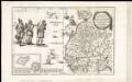
Archipelagus atlanticus cum suis insulis Canariis, Hesperidibus et Azoribus
1 : 1
Bullettino decadico dell'osservatorio ed archivio centrale geodinamico
1 : 1200000 1886/18, Blatt 1 Archivio Centrale Geodinamico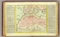
Barbarie.
1 : 11500000 Clouet, J. B. L. (Jean-Baptiste Louis), b. 1730
Evropa, 3
1 Blatt : 49 x 57 cm Homännische Erben
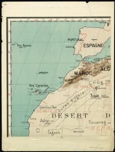
Spezial - karte von AfricaSektion West-Sahara (1)
1 : 4000000 1 full d'1 mapa en 10 fulls i estoig Hermann Habenicht; Justus Perthes
de Vlaamsche en Canarische Eylanden [Karte], in: De Nieuwe Groote Vermeerderde Zee-Atlas ofte Water-Werelt, S. 55.
1 Karte aus Atlas Doncker, Hendrick
Pascaart, Waer in men claarlyck zien can, alle havens rivieren droogten, gelegen tußchen C.S. Vincent en C. Verde [...] [Karte], in: Het vijfde Deel Des Grooten Atlas : Vervatende De Water-Weereld, S. 182.
1 Karte aus Atlas Jansson, Jan Jansson, Jan
Pascaart, Waer in men claarlyck zien can, alle havens rivieren droogten, gelegen tußchen C.S. Vincent en C. Verde [...] [Karte], in: Novus atlas absolutissimus, Bd. 9, S. 239.
1 Karte aus Atlas Janssonius Offizin
Paskaart van de cust van Portugal, Barbaria en Genehoa, beginnende van d'Barlenges tot aan C. Verde met al zyn Diepte en Drooghte dus ver Naaukeurig opgesocht door Ervaren Stuurlieden
1 : 5200000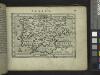
Spain.
from Abraham Ortelius his epitome of the theater of the worlde / nowe latlye ... renewed and augmented ... by Micheal Coignet, mathematitian of Antwarpe.
Carte d'une parte de l'Afrique
1 : 5860000 Afrika severozápadní Lapie, Pierre
Nieuwe pas-caart; vertoonende, hoemen uyt de canaal, de custen van Portugael, Barbarijen, de Canarische en Vlaemsche eylanden beseylen zal
1 Karte : Kupferdruck ; 42 x 54 cm Doncker by Hendrick Doncker boekverkoper inde Nieubrugsteech in 't Stuurmans gereetschap
Afrika
1 : 7500000 Afrika severozápadní Domann, Bruno Justus Perthes
Barbariæ et Guineæ maritimi à freto Gibraltar ad fluvium Gambiæ
1 Karte : Kupferdruck ; 47 x 56 cm Renard apud L. Renard
De cust van Barbaria, Gualata, Arguyn en Geneheo van Capo S. Vincent tot Capo Verde
1 Karte : Kupferdruck ; 42 x 53 cm Doncker bÿ Hendrick Doncker boecverkoper en graadboog-maker inde Nieuwe-brug-steech
De cust van Barbaria, Gualata, Arguyn, en Geneheo, van Capo S. Vincente tot Capo Verde
1 : 6000000 Annotatie: Uit: De lichtende columne, ofte zeespiegel ... - Amsterdam : Anthony Jacobsz., 1644 [Amsterdam : Anthony Jabobsz.]
De cust van Barbaria, Gualata, Arguyn en Geneheo van Capo S Vincente tot Capo Verde
1 : 6000000
A chart of the coast of Barbaria with the western, Canaria, & Cape de Verd, isles
1 : 6000000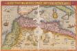
Barbarie Et Biledulgerid, Nova Descriptio. [Karte], in: Theatrum orbis terrarum, S. 317.
1 Karte aus Atlas Ortelius, Abraham
Spezial-Karte von Afrika
1 : 4000000 Blatt 1 Habenicht, Hermann Perthes
Sahara occidental et central
1 : 4000000 Afrika severozápadní Meunier, Alexandre imp. photo-métallo Millet
[135][138] Barbariae et Guineae Maritimi ..., uit: Atlas sive Descriptio terrarum orbis
Annotatie: Gedigitaliseerde versie. Amsterdam. Heiloo : Picturae (vervaardiger), 2015. tiff-bestand. Gedigitaliseerd: 07-01-2015; Origineel: Universiteitsbibliotheek Vrije Universiteit (XL.05127.-) ; Netherlands; Titelpagina ontbreekt Wit, Frederik de Amsterdam : Frederick de Wit
Le Transsaharien, conférence de Mr Paul Soleillet. Carte du chemin de fer transsaharien
1 : 20850000 Société de géographie commerciale de Bordeaux Bordeaux : Société de Géographie Commerciale de Bordeaux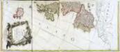
Carte generale de toute l'Europe, 1
2 Blätter : 109 x 47 cm J.M. Will