Maps of Windhoek

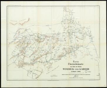
General overview of the farms in parts of the Windhoek and Karibib districts

Sheet Windhoek

Carte internationale du monde au 1,000,000 E
1 : 1000000 Windhoek (Namibie) Surveyor generals office S.W. Africa
Cote Deserte. Afrique 48.
1 : 1641836 Vandermaelen, Philippe, 1795-1869
Deutsche Kolonien
1 : 12000000 Kamerun Meyer, Joseph Bibliographisches Institut
Gross-Namaqua-Land und das Gebiet des Hauses F.A. Lüderitz
1 : 1750000 Durynsko (Německo) Hassenstein, Bruno Hahn, Th. Justus Perthes
Deutsch-Südwestafrika
1 : 2000000 Namibie Sprigade, Paul Fischer, R. Dietrich Reimer (Ernst Vohsen)
Deutsch-Südwest-Afrika
1 : 3000000 Kiepert, Richard ; Sprigade, Paul Geographische Verlagshandlung Dietrich Reimer
Kaart van Zuid-Afrika / naar de laatste en beste bronnen bewerkt voor 'De worstelstrijd der Transvalers' door F. Lion Cachet, derde herziene druk ; A.J. Wendel grav
1 : 3000000 Annotatie geografische gegevens: Met schaalstok; Legenda Abraham Jacobus Wendel 1826-1915 Pretoria [etc.] : Boekhandel voorheen Höveker & Wormser / ([Leiden : P.W.M. Trap])
Mission map of South Africa according to the map in Stieler's Atlas

Das Capland Nebst Den Sud-Afrikanischen Freistaaten.
1 : 5000000 Petermann, A.
Süd-Afrika
Hand-Atlas über alle Theile der Erde nach dem neuesten Zustande und über das Weltgebäude Stieler, Adolf bei Justus Perthes
[Süd-Afrika]
Hand-Atlas über alle Theile der Erde nach dem neuesten Zustande und über das Weltgebäude Stieler, Adolf bei Justus Perthes
South Africa.
1 : 4118400 Fullarton, A. & Co.
Das Capland nebst den Süd-Afrikanischen Freistaaten und dem Gebiet der Hottentotten & Kaffern
Hand-Atlas über alle Theile der Erde und über das Weltgebäude Stieler, Adolf Justus Perthes
South Africa.
1 : 3817440 Johnston, Alexander Keith
Union of South Afrika

Das Capland nebst den Süd-Afrikanischen Freistaaten und dem Gebiet der Hottentotten & Kaffern
Handatlas über alle Theile der Erde und über das Weltgebäude Stieler, Adolf Justus Perthes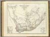
Sud. v. Africa.
1 : 3000000 Weiland, C. F. (Carl Ferdinand), d. 1847
Zuid-Afrika
1 : 10000000 steendruk van P.W.M. Trap [Amsterdam] : [s.n.]
South Africa.
1 : 10080000 Peterson, Augusts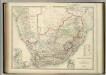
South Africa.
1 : 3817440 Johnston, W. & A.K.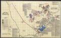
A land divided against itself.A map of South Africa showing the African Homelands and some of the mass removals of people which have taken place,..

Das Capland nebst den süd-afrikanischen Freistaaten un dem Gebiet der Hottentotten & Kaffern.

St. Helena, this island belongs to ye English east India Company whose ships usually touch here for a recruit of fresh water and provisions ... ; The bay of Agao de Saldanha, this bay is 70 miles north of ye Cape of Good Hope ...
1 : 1
Spezial-Karte von Afrika
1 : 4000000 Blatt 9 Habenicht, Hermann Perthes
Karte des Afrikander-Aufstandes im Kaplande und des Angriffskrieges der Buren
1 : 4000000 Langhans, Paul Perthes
Regna Congo et Angola. [Karte], in: Novus atlas absolutissimus, Bd. 6, S. 180.
1 Karte aus Atlas Janssonius Offizin
[LL.04716gk: 591/od/1899], uit: Kaart van Zuid-Afrika : (Zuid-Afrikaansche Republiek, Oranje-Vrijstaat en aangrenzend gebied)
1 : 5600000 Amsterdam [etc.] : J.H. de Bussy