Maps of Shanwei City
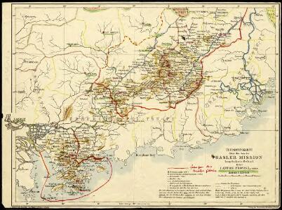
General map of the region worked on by the Basel Mission in Canton Province, China.
Lörcher, J.
The northeastern part of the Southern Chinese Province Kwangtung (Canton) with the mission stations of the Basel, Berlin and Rhenish (Barmer) missions.

Chinese Province of Kwangtung

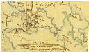
Atlas der evangelischen Missionsgesellschaft in Basel mit Angabe der Verbreitung der Hauptreligionen11. Der Sinon oder Sanon-Kreisder Chinesischen Provinz Canton

Ho-yüan
1 : 2500000 United States. Army Map Service. Army Map Service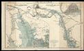
The Canton River

Shan-t'ou
1 : 2500000 United States. Army Map Service. Army Map Service
Der Sinon od. Sanon-Kreis der chinesischen Provinz Canton
Atlas der evangelischen Missions-Gesellschaft zu Basel Locher; Gross, Rudolf Im Verlag des Comptoires der evangelischen Missions-Gesellschaft
Map of the Canton Province districts of Tunkon, Sinon and Kwuisen, including the British colony Hongkong.

Hong Kong
1 : 2500000 United States. Army Map Service. Army Map Service
Lu-feng
1 : 2500000 United States. Army Map Service. Army Map Service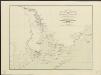
Karte des Hafens von Canton mit Macao, Whampoa, der Bocca Tigris und allen umliegenden Inseln
1 : 310000 nach der so eben in London erschienenen Karte des Herrn James Wyld gedruckt b. Rauh ; Lith. v. Geiger Wien : Verlag der Kunsthandlung H.F.M
Map of the Sun-On District (Kwangtung Province)

Map of the Hongkong and Lilong mission areas.
J. Dilger
Hong Kong and the Territory Leased to Great Britain

untitled
J. Dilger
Lung-ch'uan
1 : 2500000 United States. Army Map Service. Army Map Service
Logong and surrounding areas
Lörcher, J.
Mei-hsien
1 : 2500000 United States. Army Map Service. Army Map Service
Kuang-chou
1 : 2500000 United States. Army Map Service. Army Map Service
Kanton und Kantonstrom
1 : 800000 Kanton (Čína) F.A. Brockhaus' geogr.-artist. Anstalt
Hongkong and the New Territories

Colony of Hong Kong New Territory

Hong Kong

Kowloon and the New Territories

Kowloon and the New Territories
Collinson Map
Sketch in response to the committee minutes §1448 no. 1909
Schulze, O.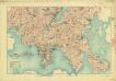
China, Kowloon and part of the new territory(1908)
China, Kowloon and part of New Territory, [G.S.G.S.] no. 2100 : reduced from a survey in 1902-1903 / by Major H.S. King R.E. Great Britain. War Office. General Staff. Geographical Section. [London] : Geographical Section, General Staff