Old maps of Southampton Island

Discover the past of Southampton Island on historical maps

Browse the old maps

Discovering the Cartography of the Past

Southampton Island


Parent places:

Maps of Southampton Island

Maps of Southampton Island

$title$

Ile Southampton. Amer. Sep. 17.

1 : 1641836 Vandermaelen, Philippe, 1795-1869
$title$

[142][145] Septemtrionaliora Americae à Groenlandia, ..., uit: Atlas sive Descriptio terrarum orbis

Annotatie: Gedigitaliseerde versie. Amsterdam. Heiloo : Picturae (vervaardiger), 2015. tiff-bestand. Gedigitaliseerd: 07-01-2015; Origineel: Universiteitsbibliotheek Vrije Universiteit (XL.05127.-) ; Netherlands; Titelpagina ontbreekt Wit, Frederik de Amsterdam : Frederick de Wit
$title$

Atlas of Canada. No. 4, Geology, west sheet

1 : 6336000 Canada. Ministère de l'intérieur [Ottawa] : Canada, Department of the Interior
$title$

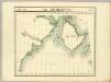
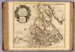
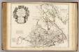
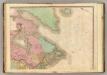
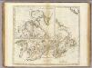
The north west part of America / by Robt. Morden.; Geography rectified, or, A description of the world: in all its kingdoms, provinces, countries, islands, cities, towns, seas, rivers, bayes, capes, ports: their antient and present names, inhabitants, situations, histories, customs, governments, &c.: as also their commodities, coins, weights, and measures, compared with those at London: illustrated with above sixty new maps: the whole work performed according to the more accurate discoveries of modern authors / by Robert Morden.

from Geography rectified, or, A description of the world : in all its kingdoms, provinces, countries, islands, cities, towns, seas, rivers, bayes, capes, ports : their antient and present names, inhabitants, situations, histories, customs, governments, &c. : as also their commodities, coins, weights, and measures, compared with those at London : illustrated with above sixty new maps : the whole work performed according to the more accurate discoveries of modern authors / by Robert Morden. Morden, Robert; Cockerill, Thomas,
$title$

Greenland, Labrador.

1 : 15000000 Peterson, Augusts
$title$

Septemtrionaliora Americæ à Groenlandia, per freta Davidis et Hudson, ad Terram Novam

1 Karte : Kupferdruck ; 48 x 55 cm Renard Louis Renard
$title$

Partie, Russie d'Asie. Asie 19.

1 : 1641836 Vandermaelen, Philippe, 1795-1869
$title$

L'Amerique Septentrionale 1.

1 : 10050000 Bonne, Rigobert, 1727-1794
$title$

Carte marine, de la B. de Baffin, et une partie d'Hudson, d'Island et Groenland

1 Karte : Kupferdruck ; 42 x 48 cm Königliche Akademie der Wissenschaften
$title$

A General Chart ... Davis Straits & Baffin Islands Bay.

1 : 19000000 Melish, John
$title$

La Baja D'Hudson Terra di Labrador e Groenlandia.

1 : 9750000 Zatta, Antonio
$title$

Charte von Mackenzie's Reisen von Montreal zu dem nördlichen Eis- und dem stillen Meere

1 : 18500000 Landes-Industrie-Comptoir
$title$

Map of the Dominion of Canada

1 : 6210000 Kanada Department of the Interior, Surveys Branch
$title$

Canada, Nouvelle France.

1 : 9000000 L'Isle, Guillaume de, 1675-1726
$title$

Canada, Nouvelle France.

1 : 9000000 L'Isle, Guillaume de, 1675-1726
$title$

Canada.

1 : 8554000 Rand McNally and Company
$title$

Le Canada, ou Nouvelle France, &c. : tireé de diverses relations des Francois, Anglois, Hollandois, &c. / par N. Sanson d'Abb'. geogr. ordre. du Roy ; A.d. Winter schulp.

from Charts and maps
$title$

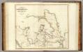
Groenland und die angraenzenden Laender nach den Charten und Berichten von Cranz, Egede, Gieseke, Graah, Olavsen, Parry, Ross, Scoresby, Thorhallesen u.a.

1 : 5000000 entworfen und gezeichnet von Theodor Gliemann Weimar : Verlag des Geograph. Instituts
$title$

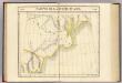
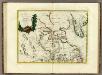
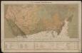
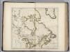
Le Canada Ou Partie Dela Nouvelle France. Contenant La Terre De Labrador La Nouvelle France, Les Isles De Terre Neuve, de Nostredame &c: [Karte], in: Atlas nouveau, contenant toutes les parties du monde [...], Bd. 2, S. 250.

1 Karte aus Atlas Sanson, Nicolas Jaillot, Alexis Hubert und Mortier, Pieter
$title$

[Nebenkarte : Tschukotka]

$title$

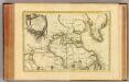
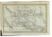
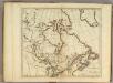
Partie orientale du Canada ou de la Nouvelle France : ou sont les provinces, ou pays de Sagvenay, Canada, Acadie etc., les peuples, ou nations des Etechemins, Iroquois, Attiquameches etc., auec la Nouvelle Angleterre, la Nouvelle Ecosse, la Nouvelle Yorc

from Charts and maps
$title$

British America.

1 : 11500000 Rand McNally and Company
$title$

Le Canada catholique

1 : 6300000 [Lyon : Oeuvre de la propagation de la foi]
$title$

North America, N.E.. Sheet.

1 : 7600000 Tanner, Henry S.
$title$

Arctic Regions.

1 : 19000000 Thomson, John
$title$

British Possessions in North America.

1 : 9100000 Carey, Mathew
$title$

British Possessions in North America.

1 : 9000000 Carey, Mathew
$title$

British Possessions in North America.

1 : 6969600 Carey, Mathew
$title$

British Possessions in North America.

1 : 7603200 Carey, Mathew
$title$

British Possessions in North America.

1 : 7286400 Lewis, Samuel
$title$

British Possessions in North America.

1 : 7603200 Carey, Mathew
© MapTiler © OpenStreetMap contributors
How does it work?
These instructions will show you how to find historical maps online.
Getting started
Type the place name in the search box to find the exact location. You can further adjust the search by zooming in and out.
Zoom
Zoom in and out with the buttons or use your mouse or touchpad natively.
Exact Area tool
Click here and draw a rectangle over the map to precisely define the search area.
Set filters
Narrow your search with advanced settings, such as Years (from/to), Fulltext, Publisher, etc.
Results
See the results of your search on the right side. You can scroll down to find more maps of this location.
?

Download OldMapsOnline Mobile