Old maps of Qeqqata Kommunia

Discover the past of Qeqqata Kommunia on historical maps

Browse the old maps

Discovering the Cartography of the Past

Qeqqata Kommunia


Parent places:

Related places:

Places

Maps of Qeqqata Kommunia

Maps of Qeqqata Kommunia

$title$

Afteekening van Oud Groenland in de Straet Davids

Greenland Bruijn, Ockkers & Groeneveld Gerard van Keulen
$title$

Oud Groenland van Staaten Hoek of C. Farawel tot de Visch Baij of Straet Davids int groot

Greenland Gerard van Keulen
$title$

Detroit de Davis. Amer. Sep. 10.

1 : 1641836 Vandermaelen, Philippe, 1795-1869
$title$

Partie du Groenland. Amer. Sep. 19.

1 : 1641836 Vandermaelen, Philippe, 1795-1869
$title$

Old Greenland.

1 : 9850000 Bowen, Emanuel
$title$

Nieuwe platte pas kaart van de Noord Occiaan van Hitland tot in de Straat Davids seer dienstig voor de Straat Davids vaarders

1 : 3800000 welke straat nu nieulijks en naaukeurig afgeteekent en beschreeven door schipper Laurens Feykes Haan en verder in 't ligt gebragt door G. van Keulen Tot Amsterdam : bij Gerard van Keulen, boek en zee-kaart verkooper, aan de Nieuwen-brug [...]
$title$

Nieuwe afteekening van de Straat Davits van Hitland tot aen de Straet Davids

Atlantic Ocean Gerard van Keulen
$title$

Gletscherkarte.

Berghaus, Hermann
$title$

Europe.

1 : 11721600 Tanner, Henry S.
$title$

Europe.

1 : 11721600 Tanner, Henry S.
$title$

Europe.

1 : 11721600 Tanner, Henry S.
$title$

Europe.

1 : 11721600 Tanner, Henry S.
$title$

L'Europe.

1 : 26500000 Fer, Nicolas de, 1646-1720
$title$

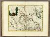
The north west part of America / by Robt. Morden.; Geography rectified, or, A description of the world: in all its kingdoms, provinces, countries, islands, cities, towns, seas, rivers, bayes, capes, ports: their antient and present names, inhabitants, situations, histories, customs, governments, &c.: as also their commodities, coins, weights, and measures, compared with those at London: illustrated with above sixty new maps: the whole work performed according to the more accurate discoveries of modern authors / by Robert Morden.

from Geography rectified, or, A description of the world : in all its kingdoms, provinces, countries, islands, cities, towns, seas, rivers, bayes, capes, ports : their antient and present names, inhabitants, situations, histories, customs, governments, &c. : as also their commodities, coins, weights, and measures, compared with those at London : illustrated with above sixty new maps : the whole work performed according to the more accurate discoveries of modern authors / by Robert Morden. Morden, Robert; Cockerill, Thomas,
$title$

Greenland, Labrador.

1 : 15000000 Peterson, Augusts
$title$

Carte réduite des mers du Nord

1 Karte : Kupferdruck ; 54 x 76 cm Verdun de la Crenne; Borda; Pingré; Petit s.n.
$title$

Septemtrionaliora Americæ à Groenlandia, per freta Davidis et Hudson, ad Terram Novam

1 Karte : Kupferdruck ; 48 x 55 cm Renard Louis Renard
$title$

L'Amerique Septentrionale 1.

1 : 10050000 Bonne, Rigobert, 1727-1794
$title$

Carte marine, de la B. de Baffin, et une partie d'Hudson, d'Island et Groenland

1 Karte : Kupferdruck ; 42 x 48 cm Königliche Akademie der Wissenschaften
$title$

Gletscherkarte

Atlas der Geologie Zittel, K.v. ; Berghaus, Hermann Justus Perthes
$title$

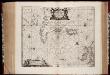
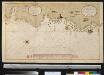
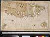
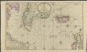
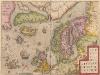
Typus Maritimus Groenlandiae, Islandiae, Freti Davidis, Insulae Iohannis Mayen, et Hitlandiae, Scotiae, et Hiberniae litora maritima Septentrionalia

1 : 7000000 Annotatie: Paskaart van de noordelijke Atlantische Oceaan met de kusten van met name het gebied tussen de Faeroër Eilanden, Groenland en Baffin Island; Origineel is Blad 149 in atlas factice; Kaart bevat diverse kompasrozen en is gedecoreerd met afbeeldingen van schepen en een walvis; Annotatie geografische gegevens: Met drie schaalstokken [Amstelodami] : [Apud Ioannem Ianßonium]
$title$

A General Chart ... Davis Straits & Baffin Islands Bay.

1 : 19000000 Melish, John
$title$

La Baja D'Hudson Terra di Labrador e Groenlandia.

1 : 9750000 Zatta, Antonio
$title$

Septentrionalium Regionum Descrip. [Karte], in: Theatrum orbis terrarum, S. 286.

1 Karte aus Atlas Ortelius, Abraham
$title$

Canada, Nouvelle France.

1 : 9000000 L'Isle, Guillaume de, 1675-1726
$title$

Canada, Nouvelle France.

1 : 9000000 L'Isle, Guillaume de, 1675-1726
$title$

Septentrionalium regionum descriptio

1 : 28000000 1 Karte : Kupferdruck ; 8 x 11 cm Galle, Philippe [Christophe Plantin]
$title$

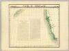
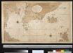
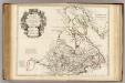
Groenland und die angraenzenden Laender nach den Charten und Berichten von Cranz, Egede, Gieseke, Graah, Olavsen, Parry, Ross, Scoresby, Thorhallesen u.a.

1 : 5000000 entworfen und gezeichnet von Theodor Gliemann Weimar : Verlag des Geograph. Instituts
$title$

Pas-caerte van Groenlandt, Yslandt, Straet Davids en Ian Mayen Eylant

1 Karte : Kupferdruck ; 43 x 52 cm Doncker bÿ Hendrick Doncker boekverkoper en graadbooghmaker inde Nieubrughsteegh
$title$

[Nebenkarte : Tschukotka]

© MapTiler © OpenStreetMap contributors
How does it work?
These instructions will show you how to find historical maps online.
Getting started
Type the place name in the search box to find the exact location. You can further adjust the search by zooming in and out.
Zoom
Zoom in and out with the buttons or use your mouse or touchpad natively.
Exact Area tool
Click here and draw a rectangle over the map to precisely define the search area.
Set filters
Narrow your search with advanced settings, such as Years (from/to), Fulltext, Publisher, etc.
Results
See the results of your search on the right side. You can scroll down to find more maps of this location.
?

Download OldMapsOnline Mobile