Old maps of Nunatsiavut

Discover the past of Nunatsiavut on historical maps

Browse the old maps

Discovering the Cartography of the Past

Nunatsiavut


Parent places:

Maps of Nunatsiavut

Maps of Nunatsiavut

$title$

Partie du Labrador. Amer. Sep. 28.

1 : 1641836 Vandermaelen, Philippe, 1795-1869
$title$

Partie du Labrador. Amer. Sep. 29.

1 : 1641836 Vandermaelen, Philippe, 1795-1869
$title$

Karten-Skizze des Treibeises bei Newfundland während der Zeit vom 11. März bis zum 5. Mai 1891, nach den Berichten, welche bis zum 20. Mai eingegangen sind

Newfoundland (Kanada : ostrov)
$title$

Karten-Skizze des Treibeises bei Newfundland während der Zeit von Anfang Mai bis Ende Juni, nach den Berichten, welche bis zum 8ten Juli eingegangen sind

Newfoundland (Kanada : ostrov)
$title$

188-189. Canada, East. The World Atlas.

1 : 5000000 USSR (Union of Soviet Socialist Republics).
$title$

Oud Groenland van Staaten Hoek of C. Farawel tot de Visch Baij of Straet Davids int groot

Greenland Gerard van Keulen
$title$

A new map of the province of Quebec in North America, drawn from the best authorities

1 : 6500000
$title$

A Map of the British Empire in America. (Sheet 3).

1 : 2000000 Popple, Henry
$title$

A Map of the British Empire in America. (Sheet 3).

1 : 2000000 Popple, Henry
$title$

Een gedeelte van de Oostkust van Labrador

Canada Johannes van Keulen
$title$

Paskaert van de Noordelijckste kuste van America van Groenland door de Straet Davis en de Straet Hudson tot Terra Neuf

1 : 8000000 Colom, Jacob Aertsz Colom, Jacob Aertsz
$title$

British Provinces of North America.

1 : 10000000 Cornell, S. S. (Sarah S.)
$title$

North-eastern Canada.

1 : 5000000 John Bartholomew and Son
$title$

Geology. East sheet

1 : 6336000
$title$

Canada, N. pt. Louisiana.

1 : 7700000 Jefferys, Thomas
$title$

Canada

1 : 10120000 Kanada Bonne, Rigobert André
$title$

Nieuwe platte pas kaart van de Noord Occiaan van Hitland tot in de Straat Davids seer dienstig voor de Straat Davids vaarders

1 : 3800000 welke straat nu nieulijks en naaukeurig afgeteekent en beschreeven door schipper Laurens Feykes Haan en verder in 't ligt gebragt door G. van Keulen Tot Amsterdam : bij Gerard van Keulen, boek en zee-kaart verkooper, aan de Nieuwen-brug [...]
$title$

Nieuwe afteekening van de Straat Davits van Hitland tot aen de Straet Davids

Atlantic Ocean Gerard van Keulen
$title$

[142][145] Septemtrionaliora Americae à Groenlandia, ..., uit: Atlas sive Descriptio terrarum orbis

Annotatie: Gedigitaliseerde versie. Amsterdam. Heiloo : Picturae (vervaardiger), 2015. tiff-bestand. Gedigitaliseerd: 07-01-2015; Origineel: Universiteitsbibliotheek Vrije Universiteit (XL.05127.-) ; Netherlands; Titelpagina ontbreekt Wit, Frederik de Amsterdam : Frederick de Wit
$title$

North America 2.

1 : 4470000 Arrowsmith, Aaron
$title$

Pascaert om van Texel na de Straet Davids en Hutson te zijlen zijnde ook seer dienstig voor de gene die agterom koomen voornamentlijk voor de Westindise en Guneese schipvaert

Atlantic Ocean Gerard van Keulen
$title$

Europe.

1 : 11721600 Tanner, Henry S.
$title$

Europe.

1 : 11721600 Tanner, Henry S.
$title$

Europe.

1 : 11721600 Tanner, Henry S.
$title$

Europe.

1 : 11721600 Tanner, Henry S.
$title$

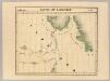
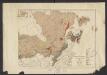
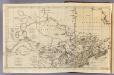
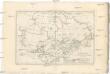
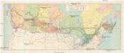
The north west part of America / by Robt. Morden.; Geography rectified, or, A description of the world: in all its kingdoms, provinces, countries, islands, cities, towns, seas, rivers, bayes, capes, ports: their antient and present names, inhabitants, situations, histories, customs, governments, &c.: as also their commodities, coins, weights, and measures, compared with those at London: illustrated with above sixty new maps: the whole work performed according to the more accurate discoveries of modern authors / by Robert Morden.

from Geography rectified, or, A description of the world : in all its kingdoms, provinces, countries, islands, cities, towns, seas, rivers, bayes, capes, ports : their antient and present names, inhabitants, situations, histories, customs, governments, &c. : as also their commodities, coins, weights, and measures, compared with those at London : illustrated with above sixty new maps : the whole work performed according to the more accurate discoveries of modern authors / by Robert Morden. Morden, Robert; Cockerill, Thomas,
$title$

Canadian national railways

1 : 4730000 Kanada
$title$

Pulp & paper map of Canada

1 : 6270000 Kanada Department of the Interior
$title$

Greenland, Labrador.

1 : 15000000 Peterson, Augusts
$title$

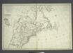
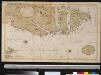
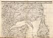
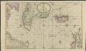
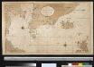
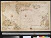
Carte nouvelle de l'Amerique angloise: contenant la Virginie, Mary-Land, Caroline, Pensylvania, Nouvelle Iorck, N. Iarsey, N. France, et les terres nouvellement decouerte dressé sur les relations les plus nouvelles / par le Sieur S.

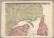
from John H. Levine Collection le Sieur S.,
© MapTiler © OpenStreetMap contributors
How does it work?
These instructions will show you how to find historical maps online.
Getting started
Type the place name in the search box to find the exact location. You can further adjust the search by zooming in and out.
Zoom
Zoom in and out with the buttons or use your mouse or touchpad natively.
Exact Area tool
Click here and draw a rectangle over the map to precisely define the search area.
Set filters
Narrow your search with advanced settings, such as Years (from/to), Fulltext, Publisher, etc.
Results
See the results of your search on the right side. You can scroll down to find more maps of this location.
?

Download OldMapsOnline Mobile