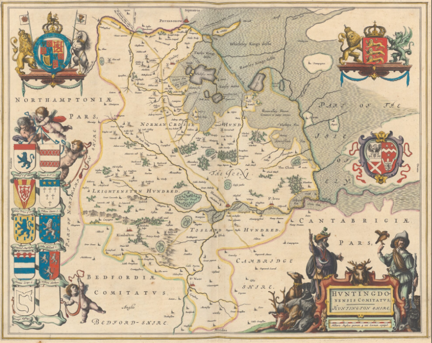
More than 2900 digitized maps from the most magnificent atlases of the Zentralbibliothek Zürich archives are waiting to be geographically located by those interested. Often ornately decorated maps from 15th-17th century splendor atlases were selected for this project. Discover how, as the world was explored, outlines of land masses on maps changed or borders shifted due to disputes. There are also imaginary islands and sea monsters in the ocean and wild animals on land to discover.
To help match scanned historical maps to the real world, please visit https://www.zb.uzh.ch/de/ueber-uns/citizen-science/prachtsatlanten-alte-landkarten-georeferenzieren
Compare and overlay maps with each other! In the new version released in December 2022, we integrated the Compare tool into the www.oldmapsonline.org search engine. Now you can easily study the evolution of a place in different time periods by visually comparing different maps. Work with two or more maps together, stack the maps in a pile, adjust transparency to compare the maps with each other, and favorite maps you like the most.
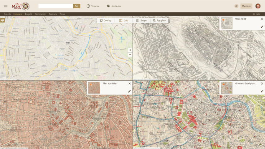
You can find favorited maps anytime in the newly added “My maps” section. Upload and georeference scanned maps and create your own map collection.
We also optimized the system and prepared our online tool for implementation of new features that will appear soon in the following oldmapsonline.org versions.
From its first launch in 2012, the website has had millions of visitors and thanks to our partners, such as The British Library, National Library of Scotland, David Rumsey, Harvard Library, Dutch National Archives, Charles University in Prague and many other institutions worldwide, OldMapsOnline is currently indexing over 527,000 historical maps.
Visit oldmapsonline.org, explore collections of historical maps, find places of your interest, compare and overlay your favorite maps and immerse yourself in exploring the past.
We are open to cooperation, and we welcome your constructive feedback which you can send via https://support.oldmapsonline.org/knowledgebase or via [email protected].
oldmapsonlineA new crowdsourcing project of Utrecht University Library! A total of 847 maps from “Atlas Maior” and “Toonneel der Steden” by Joan Blaeu have been added to Georeferencer application and are ready for georeferencing. The Atlas Maior is the final version of Joan Blaeu’s atlas published in Amsterdam in 1662-1672, which contains 594 maps and approximately 3.000 pages of text, and was the largest and most expensive book published in the seventeenth century.
For more information about this collection please visit: https://www.uu.nl/en/special-collections/the-treasury/maps-and-atlases/atlas-maior-by-blaeu and help to match scanned historical maps to the real world at: https://uu.georeferencer.com/start

Following the successful completion of Zentralbibliothek Zürich’s georeferencer pilot “Durch Raum und Zeit”, maps from the ZB georeferenced collections have been added to the OldMapsOnline search portal.
Explore Switzerland between the 16th and 19th centuries and enjoy a beautiful collection of historical maps.
With these 2,500 maps, the number of indexed historical maps in OldMapsOnline has grown to more than 520,000. We invite all historical map enthusiasts from the general public and the research community to explore maps not only in Switzerland but also in other countries.
Check the new collection on OldMapsOnline
oldmapsonlineNew Georeferencer crowdsourcing pilot has been released for Zentralbibliothek Zürich. More than 2500 digitized old Zürich and Swiss maps from the Maps and Panoramas Department of Zurich’s central library are waiting to be georeferenced. Help to locate geographically old maps from three collections:
Zeitreise Kanton Zürich: In this collection, you can find 840 maps, which essentially show the area or parts of today’s Canton of Zurich.
Landkarten made in Zurich: This collection includes over 1000 maps that were designed or printed in Zurich. In addition to maps showing the area of other cantons, there are also maps of Switzerland and city and bird plans, such as Johann Jakob Scheuchzer’s bird plan of the city of Lucerne: “La ville de Lucern, en Suisse” from 1723.
Alte Schweizerkarten: The large number of 645 Swiss maps include highlights such as the map “Helvetia prima Rheni et V. nova tabula” from Sebastian Münster’s “Geographia universalis” from 1540.
For more information about this project please visit: https://www.zb.uzh.ch/en/ueber-uns/citizen-science/durch-raum-und-zeit
georeferencerThe Moravian Library in Brno, Czech Republic announces the results of the successful georeferencing contest, which was launched this year on the Staremapy.cz portal.
The crowdsourcing online event ran from July 8 to August 31 and a total of 2797 old maps were successfully georeferenced and processed by the online volunteers.
In less than two months, the participants working over the Internet from the comfort of their home identified a total of 62205 location points in the scanned maps and connected them to modern locations. This effort, among other things, made it easier, to discover the scanned old maps in the catalogues and international search databases and overlay them on top of modern maps - to compare the past with the present.
The new georeferenced maps from the Moravian Library and other domestic and foreign map collections can be found through the OldMapsOnline.org portal.
The OldMapsOnline project helps to make the historical maps more accessible to the general public. A large number of maps are stored in the collections of Czech cultural heritage institutions, which have been undergoing digitalization in recent years.
The Czech National TV broadcasted a report about this georeferencing pilot and map collection of the Moravian Library in the tv news.
Video from ceskatelevize.cz - © Copyright 2020 Ceska Televize. Reportage in czech language.
georeferencerWe are continuously and constantly enlarging the number of maps in our search engine database OldMapsOnline.org. We have recently added new historical maps and you can now search and explore maps from Utrecht University Library collections, Leiden University collections and many others. Currently, we have almost 500.000 maps listed thanks to all the participating institutions.
Please see the list of institutions that helped us.
oldmapsonlineWe have modernised our Bounding Box tool and added new features!
The tool is freely available at http://boundingbox.klokantech.com and allows visual selection of geographic coordinates of an area on a map directly in a web browser.
It is a popular tool used regularly by many librarians all over the world - during cataloguing of maps. It allows direct copy&paste of the selected area into a library system in various formats such as MARC, DublinCore, FGDC or ISO 19139. Thanks to this effort the maps can be discovered with a geographical search - for example at OldMapsOnline.org.
It is practical also for GIS people - who can get the bounding box in GeoJSON, KML, or OGC WKT for use in PostGIS or SQL.
What is new?
The drawn rectangle can now be rotated for higher precision (by dragging the circle in the bottom-right corner) - this is often required for recording area of maps which are not north oriented - for examples riverbed maps.
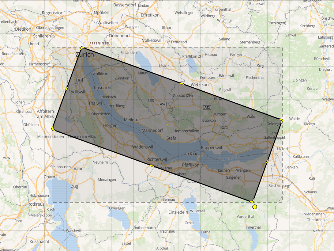
And there is also a completely new “Polygon tool” accessible by clicking the pentagon icon on the left side. This allows you to draw (and modify) any shape with high precision:
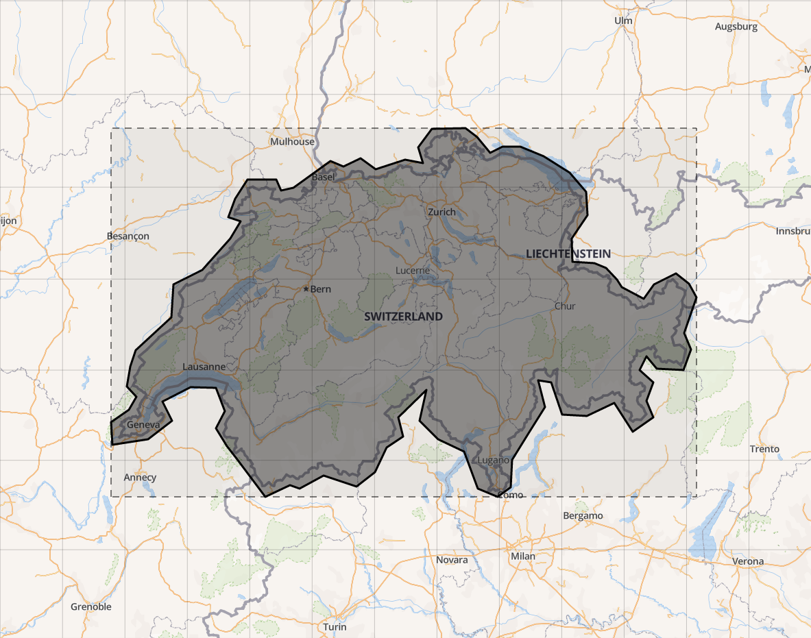
In both cases, the full geometry is formatted into the MARC format (fields 34 and 255). The wrapping bounds, automatically calculated and shown as the dashed rectangle on the map, can be included too.
The tool has been also upgraded to latest mapping library (OpenLayers) and we are now using as the default background layer the OpenStreetMap maps from the OpenMapTiles.org open-source project.
The development has been supported by the Swiss libraries as part of the Kartenportal.CH project.
maps | oldmapsonline | osgeoSome of the historical maps are unfortunately not north-oriented. To turn the map while georeferencing will save time and help to find the depicted places.
In the new user interface, it is possible to rotate the map while holding Alt+Shift.
The rotation is also automatically calculated after you assign first two ground control points on a map!
This feature will make the georeferencing easier and more convenient for the users. The rotation feature is now developed, applied in the Cynefin pilot project, and it is going to be a part of the next generation of Georeferencer service.
Following short movie shows the rotation feature:
georeferencerTithe Maps are interesting source of historical information from 19th century in the United Kingdom.
During our project, we came to a new challenge: Each map was accompanied by a schedule listing each map item by number. Next to it, we needed to create a connection between the map itself and the accompanied listing with further information about the individual parts of the map.
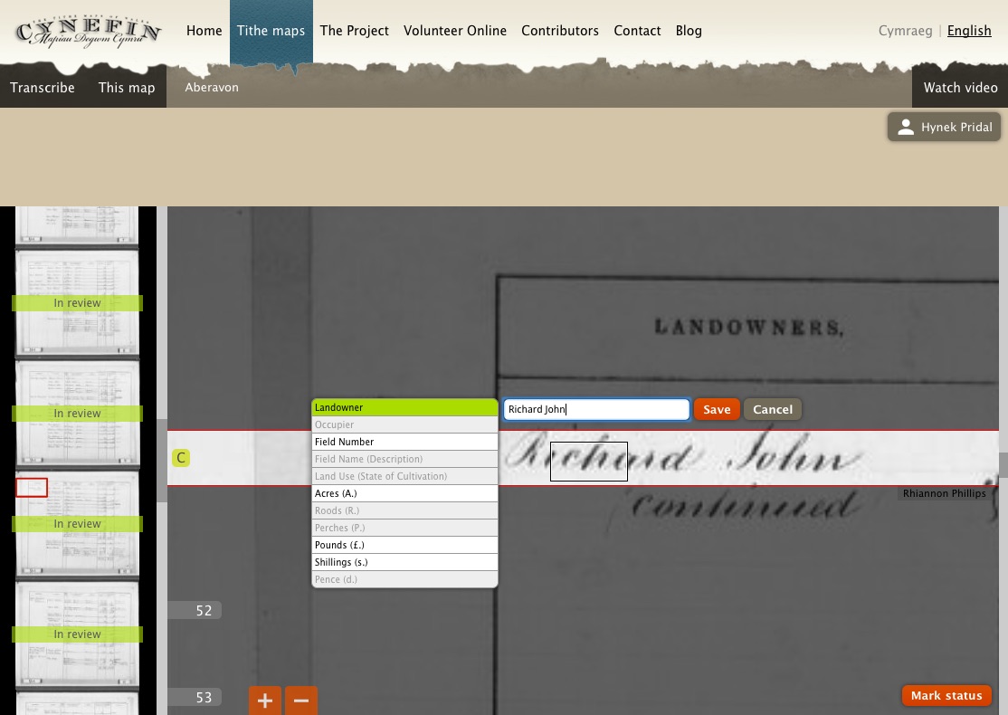
New generation of Georeferencer will be able to handle textual information on the maps and connect the content with another sheets if needed. IIIF technology was used to handle high-resolution scans together with our IIIF viewer. This enabled us to add transcriptions and rotate the maps directly in the web viewer.
The preview of transcription tool is available in the following tutorial:
georeferencerOver 400 historical maps have been released by Technical University Darmstadt in a new Georeferencer pilot. The map collection of ULB has around 37.000 sheets from 16th to 20th century. Over 1.000 of them is scanned already and are coming back to the online life. Information about the project can be found at: http://www.ulb.tu-darmstadt.de/spezialabteilungen/kartensammlung/georeferenzierung/index.de.jsp
georeferencer | customersMap lovers will find hours and hours worth of cartographic joys on this site that draws sources from the U.S. Geological Society, the National Library of Scotland, the Land Survey Office of the Czech Republic, and many other participating institutions. Beginning as a project between Klokan Technologies GmbH, Switzerland and The Great Britain Historical GIS Project, OldMapsOnline “aims to demonstrate a combination of tools for publishing historical maps with a focus on their easy accessibility for the general public.
Full review available at: https://scout.wisc.edu/report/2015/1127#11land and The Great Britain Historical GIS Project, OldMapsOnline “aims to demonstrate a combination of tools for publishing historical maps with a focus on their easy accessibility for the general public.
oldmapsonlineIn Leiden University, over 300 of hand-drawn manuscript maps from the collection Van Keulen have been georeferenced in the new pilot. The maps were drawn between 1704-1755.
After more then 300 years it was quite tricky to place the control points, as nearly all places are using different names and on some places the landscape shape was changed significantly as well.
More information about the project available at: http://www.library.leiden.edu/special-collections/special/maps-in-the-crowd-eng.html#participate-and-win
georeferencer | customersOldMapsOnline is a search engine for maps that allows visitors to explore and discover the beauty of historical maps depicting a past geographical place of their interest. In the new version released in July 2015, additional maps have been added and the website already indexes over 400,000 scanned maps from collections of The British Library, National Library of Scotland, David Rumsey, Harvard Library, Dutch National Archives, Charles University in Prague, New York Public Library and other institutions worldwide. It is a well-known project in the cultural heritage sector. From its first launch in 2012, the website has had over 1,500,000. OldMapsOnline provides a single entry point for searching maps of the same geographical location without the need to know which library holds the actual map. This is a real benefit for researchers and students because it saves their time, effort and costs. For more information visit www.oldmapsonline.org. launch in 2012, the website has had over 1,500,000. OldMapsOnline provides a single entry point for searching maps of the same geographical location without the need to know which library holds the actual map. This is a real benefit for researchers and students because it saves their time, effort and costs. For more information visit www.oldmapsonline.org.
oldmapsonlineGlad to see another Georeferencer project for State Library New South Wales in Australia. The tricky part of this project were significant changes in names of the streets, which needed the contributors with local knowledge.
Over 900 maps were successfully placed and the obtained data enriched the library catalogue with geographical locations. More information about the project is available at http://www.sl.nsw.gov.au/using/map_georeferencing.html
georeferencer | customersWe are glad to see our IIIF Viewer applied on various websites. IIIF Viewer is an Open-Source component brought by Klokan Technologies. IIIFViewer is optimized for desktop and mobile devices (iOS, Android), is open-source, free to use and has, compared to other viewers, the following extra features:
Code is available on GitHub.
See examples of usage.
A nice example are the Maps of Scotland from the National Library of Scotland.
customers | tileserver | iiif | open-source | iipimageWe would like to give advanced notice to all our users that the infrastructure that our sites and services run on is being upgraded. This is essential maintenance and whilst it is happening Old Maps Online will be partially, and at times may be completely, unavailable.
This will occur on Saturday 17th January 2015 between 10 am and 5 pm (Central European Time).
We apologise for any inconvenience caused.
Available on our website is a complex overview on how to publish large images, such as scans or maps.
The text was prepared for culture heritage institutions, which often struggle with the publishing process.
This step-by-step explanation helps you gain insight about available tools and presents tested solutions that are easily applicable for anybody who needs to bring visual content online.
The article is available at: www.klokantech.com/cultural-heritage
presentations | oldmapsonline | osgeo | georeferencer | maps | tileserver | iiif | mapranksearch | open-source | iipimage | omekaA new application of Georeferencer was announced 7th November 2014 in New York.
This time, another 40.000 maps have been published by David Rumsey and are available for online georeferencing.
Try it yourself at http://rumsey.georeferencer.com/random
New features of Georeferencer (coming up with this project):
Video tutorial is available at:
Petr from Klokan Technologies took part in the meeting and workshop in the New York Public Library. The aim of this meeting was to unify the processes of digitization of Old maps and provide a way, that would enable its further analysis.
In one room, experts from Harvard, Yale, Tuffts, Stanford, Library of Congress, British Library and many other institutions met and discussed. Interesting was a project OpenHistoricalMap.org, which is similar to the OpenStreetMap.org, but with focus on historical data and changes with a time. It is possible to view, when were different buildings created, what were their names in the time etc..
There are also other great projects to mention, just like NYPL Building Inspector, HistoryPin, or projects for toponyms and documents processing like Pelagios, PastPlace / VisionOfBritain, etc.
Presentations from the event are available at: http://on.nypl.org/histgeo
presentations
February 2023
“Prachtsatlanten” - a new g...
January 2023
OldMapsOnline - new version...
May 2022
Utrecht University - "Atlas...
January 2022
Swiss Maps Added to OldMaps...
June 2021
Zentralbibliothek Zürich - ...
October 2020
Successful pilot of Moravia...
4000 new maps in OldMapsOnline
May 2017
Bounding Box tool improvements
May 2016
Rotation of a map in Georef...
December 2015
Transcription in Georeferencer
Georeferencer for TU Darmstadt
November 2015
OldMapsOnline.org in Intern...
August 2015
Georeferencer for Leiden Un...
July 2015
OldMapsOnline - new version...
June 2015
Georeferencer for State Lib...
March 2015
IIIF viewer at The National...
December 2014
Planned downtime: Saturday ...
Publish maps and large imag...
November 2014
Georeferencer for David Rum...
New York Public Library: Mo...
October 2014
IIIF for images in cultural...
August 2014
Utrech University used our ...
July 2014
National Library of Scotlan...
April 2014
Open Data Award in Apps For...
March 2014
Impact video now available
November 2013
The British Library Georefe...
Battersea Arts Centre Digit...
The Austrian National Libra...
October 2013
His Majesty King Willem-Ale...
September 2013
FOSS4G 2013: Old Maps Onlin...
WebGL accelerated Georefere...
Old Maps Online at the Inte...
July 2013
Coding session of our devel...
June 2013
The Bounding Box Tool descr...
April 2013
Preserved for posterity
Map overlays with WebGL: af...
January 2013
British Library: 3rd Georef...
Online reviews of Old Maps ...
Edinburgh Conference: Worki...
December 2012
Petr Přidal awarded Barthol...
November 2012
AHRC Digital Transformation...
BMArchives.org launched
Focus on the Collections: T...
Old Maps Online - so what?
October 2012
New crowd-sourced Geo-refer...
Focus on the collections: A...
July 2012
Google think we are cool ...
New article published about...
Google I/O 2012 - Google in...
World History Association C...
June 2012
Google I/O conference 2012
"The best search service fo...
Presenting at Geoforum: Old...
JISC Programme Manager's visit
Presentation & Steering Gro...
May 2012
General project update May ...
LIBER Groupe des Cartothéca...
Showcased on Google Develop...
April 2012
Old Maps Online and Georefe...
Publicising Old Maps Online
March 2012
Meet us at ICA Digital Appr...
Review of Old Maps Online L...
Publicity for Old Maps Onli...
Site a bit more stable now
Best laid plans ...
British Library Geo-referen...
February 2012
Old Maps Online Launched
Course: Working Digitally w...
The British Library: Georef...
Progress towards Old Maps O...
Workshop: Working Digitally...
UK Archives Discovery Forum...
January 2012
Progress towards Old Maps O...
Free One Day Conference: Lo...
November 2011
New ‘Old Maps Online’ proje...
October 2011
Our Culture Globe wins Euro...
May 2011
National Archives of the Ne...
April 2011
Digital Approaches in Carto...
November 2010
National Library of Scotlan...
May 2010
NLS Maps API: historical ma...
January 2010
Meet us at the ICA CartoHer...
IIPImage JPEG2000: Free Sof...
October 2009
Workshop in Scotland (BCS M...
July 2009
Poster at ICHC 2009
June 2009
ELAG: Workflow for old maps...
May 2009
MapTiler: Desktop applicati...
December 2008
Meet us at ELAG 2009!
November 2008
Mashups and tiles a la Goog...
October 2008
MapAnalyst Online: Accuracy...
September 2008
Article: Tiles as an approa...
August 2008
Old Maps Search Interface -...
July 2008
Georeferencing Images by Co...
Introduction of OldMapsOnli...
June 2008
Image Server IIPImage now s...
OpenLayers support for Zoom...
May 2008
OldMapsOnline Project Started